Hottest Week So Far This Year; Storms Few And Far Between
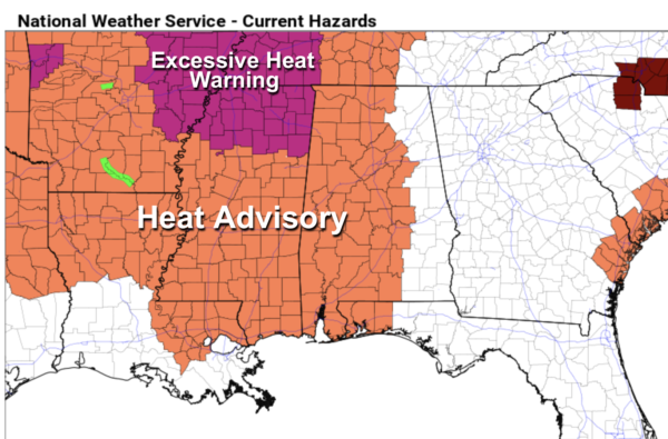
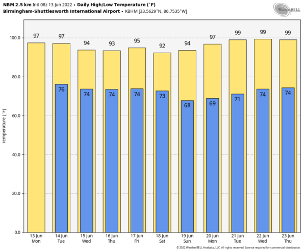
HERE COMES THE HEAT: A strong upper ridge will push the jet stream well to the north of here this week, and will set the stage for the hottest weather so far this year for Alabama and the Deep South. Look for highs most days in the mid 90s with partly to mostly sunny days and fair nights. NWS Birmingham has issued a “heat advisory” for about the western 2/3 of the state because of the combined impact of heat and humidity (heat index values will be over 100), but understand all of Alabama, including the eastern counties, will be very hot this week.
While we don’t expect any organized or widespread rain this week due to the subsidence (sinking air) associated with the upper ridge, understand a few random showers or storms could pop up during the afternoon and evening hours. Chance of any one location seeing rain today and tomorrow is 15-25 percent; odds will be a a bit higher Wednesday and Thursday as the air aloft will be a little cooler (25-35 percent).
THE ALABAMA WEEKEND: Some evidence temperatures might be a few degrees lower Saturday and Sunday with highs in the 90-93 degree range; the weather looks dry with sunny days and fair nights. Chance of a cooling shower is very, very small both days.
NEXT WEEK: The upper ridge holds; highs again will be in the mid 90s most days with only isolated afternoon storms. Most likely the pattern will hold through the rest of June; See the Weather Xtreme video for maps, graphics, and more details.
TROPICS: The Atlantic basin remains very quiet this morning. However, an area of low pressure is expected to develop by the middle part of this week over the southwestern Caribbean Sea. Some slow development of this system is possible thereafter while it drifts generally northwestward off the coasts of Nicaragua and Honduras. NHC gives it only a 20 percent of development; no issues for the Gulf of Mexico this week.
ON THIS DATE IN 1972: Severe weather conditions over the Yucatan peninsula in Mexico begin to converge and form a tropical depression that would become Hurricane Agnes over the next two weeks. This hurricane affected most of the eastern United States with the Northeast being the hardest hit area with heavy rainfall.
ON THIS DATE IN 1976: A deadly tornado moved across parts of the southwestern Chicago, Illinois suburbs killing three people and injured 23 others. The tornado, with winds over 200 mph moved from Lemont to Downers Grove causing $13 million in damage when 87 homes were destroyed, and another 90 were damaged. The tornado passed over the Argonne National Laboratory, peeling part of a roof of the building housing a nuclear reactor.
BEACH FORECAST: Click here to see the AlabamaWx Beach Forecast Center page.
WEATHER BRAINS: Don’t forget you can listen to our weekly weather show all about weather anytime on your favorite podcast app. James Spann and a team of meteorologists from around the nation bring on interesting guests; a great podcast for weather geeks/dweebs/weenies.
Look for the next Weather Xtreme video here by 3:00 this afternoon… enjoy the day!
Category: Alabama's Weather, ALL POSTS, Weather Xtreme Videos


