Clouds Linger Today; Some Rain Still Possible
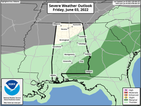
RADAR CHECK: A fairly large area of light rain is creeping into West Alabama early this morning… otherwise clouds cover most of the state at daybreak with temperatures around 70 degrees. The surface front that was initially expected be near U.S. 80 this morning is still near the Tennessee state line, so we will need to delay the clearing forecast until late today and tonight. Clouds will hang tough much of the day today with some light rain possible… temperatures will hold in the 70s much of the day. A few stronger storms are possible this afternoon ahead of the front over Southeast Alabama, where SPC maintains a “marginal risk” (level 1/5) of severe thunderstorms due to the potential of hail and gusty winds.
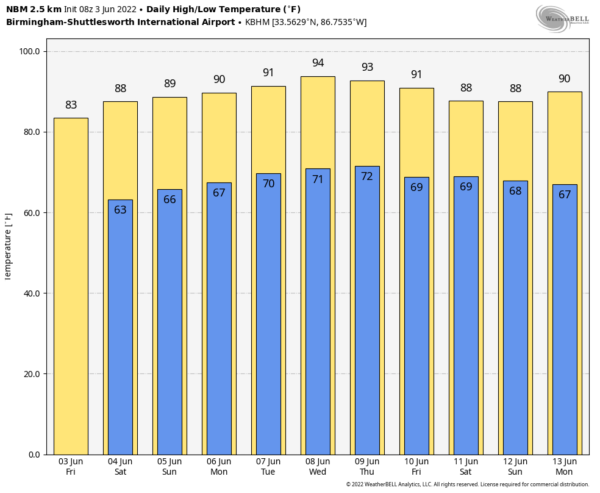
THE ALABAMA WEEKEND: Look for a good supply of sunshine tomorrow with a high in the mid 80s; cooler spots will start the day down in the 50s. Sunday will feature a partly sunny sky with just a few isolated afternoon showers around. The chance of any one spot seeing rain Sunday is only about one in eight, and the high will be in the upper 80s.
NEXT WEEK: The pattern looks pretty quiet for Alabama and the Deep South next week. It is that time of the year when you will have some risk of isolated showers most afternoons… better coverage of showers next week will be across the Tennessee Valley, close to a stalled surface front that will be over Tennessee. Highs through the week will be at or just over 90 for most places; See the Weather Xtreme video for maps, graphics, and more details.
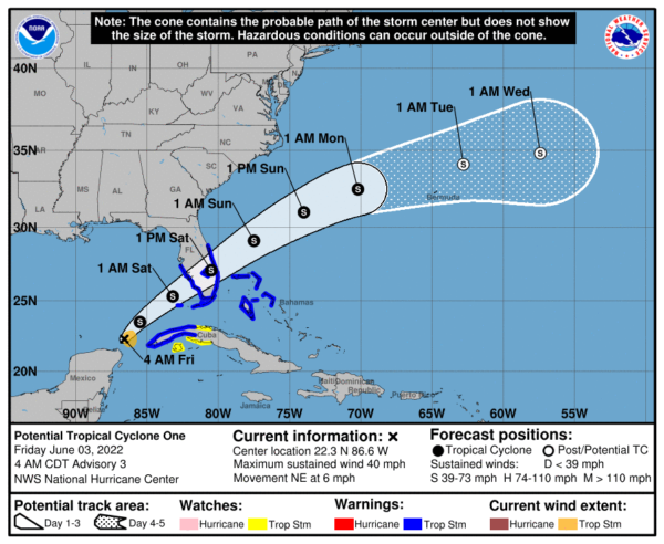
TROPICS: “Potential Tropical Cyclone One” is over the far southern Gulf of Mexico this morning. Data from an Air Force Reserve Hurricane Hunter aircraft indicate that maximum sustained winds have increased to near 40 mph with higher gusts. The system is expected to develop a well-defined center and become a tropical storm later today (the name will be Alex), and some slight strengthening is possible while it approaches Florida today and tonight. Additional strengthening is possible after the system moves east of Florida over the western Atlantic late Saturday and Sunday.
The main impact on the U.S. will be heavy rain for South Florida; amounts of 5-10 inches are likely south of I-4 through Saturday. Wind gusts of 40-45 mph are possible as well.
The rest of the Atlantic basin is quiet.
ON THIS DATE IN 1993: Early morning severe thunderstorms dumped huge hailstones across northern Oklahoma. Hail, up to 6 inches in diameter in Enid, went through roofs of homes, damaged three jets at Vance Air Force Base, and did $500,000 in damage at a car dealership. Winds gusts reached 70 mph at Vance Air Force Base as well. Hail damage to the wheat crop was estimated at 70 million dollars.
BEACH FORECAST: Click here to see the AlabamaWx Beach Forecast Center page.
WEATHER BRAINS: Don’t forget you can listen to our weekly weather show all about weather anytime on your favorite podcast app. James Spann and a team of meteorologists from around the nation bring on interesting guests; a great podcast for weather geeks/dweebs/weenies.
CONNECT: You can find me on all of the major social networks…
Look for the next Weather Xtreme video here by 3:00 this afternoon… enjoy the day!
Category: Alabama's Weather, ALL POSTS, Weather Xtreme Videos


