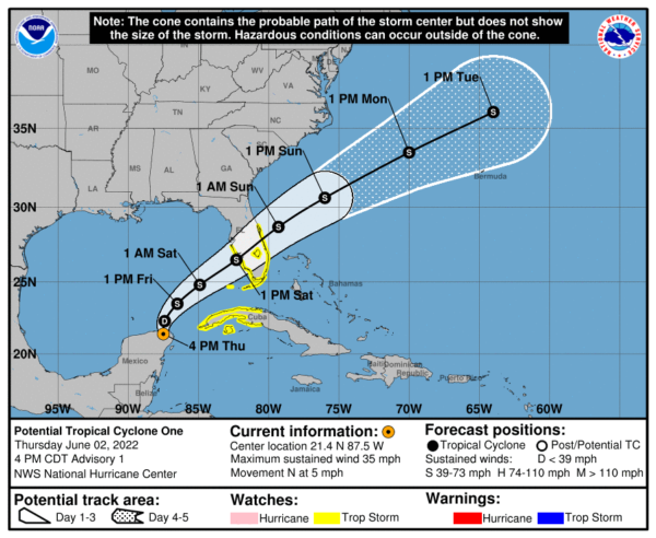
First Advisory on Potential Tropical Cyclone One; Tropical Storm Watch Issued for Portions of Florida & Cuba
* HEAVY RAINFALL TO SPREAD OVER PORTIONS OF CUBA, THE FLORIDA KEYS, AND SOUTHERN FLORIDA ON FRIDAY AND SATURDAY WITH FLOODING POSSIBLE
* TROPICAL STORM WATCH ISSUED FOR PORTIONS OF THE FLORIDA PENINSULA, THE FLORIDA KEYS, AND CUBA
SUMMARY OF 400 PM CDT…2100 UTC…INFORMATION
———————————————-
LOCATION…21.4N 87.5W
ABOUT 75 MI…120 KM NNW OF COZUMEL MEXICO
ABOUT 505 MI…810 KM SW OF FT. MYERS FLORIDA
MAXIMUM SUSTAINED WINDS…35 MPH…55 KM/H
PRESENT MOVEMENT…N OR 360 DEGREES AT 5 MPH…7 KM/H
MINIMUM CENTRAL PRESSURE…1003 MB…29.62 INCHES
WATCHES AND WARNINGS
——————–
A Tropical Storm Watch is in effect for..
* West coast of Florida south of the Middle of Longboat Key
* East coast of Florida south of the Volusia/Brevard County Line
* Florida Keys including the Dry Tortugas
* Lake Okeechobee
* Florida Bay
* Cuban provinces of Matanzas, Mayabeque, Havana, Artemisa, Pinar del Rio, and the Isle of Youth
A Tropical Storm Watch means that tropical storm conditions are possible somewhere within the watch area within 48 hours.
KEY MESSAGES
——————–
1. Heavy rain associated with the system is expected to continue through Friday across the eastern portions of the Yucatan Peninsula, the Cayman Islands and western Cuba. Life-threatening flash flooding and mudslides are possible across western Cuba.
2. Heavy rain will begin to affect South Florida and the Florida Keys Friday and continue through Saturday. Considerable flash and urban flooding is possible across the urban corridors in South Florida and in the Keys.
3. Tropical storm conditions are possible in the watch area in western Cuba Friday and Friday night, and are possible in the watch area in the Florida Peninsula and Florida Keys Friday night and Saturday.


