Tropical Update: Depression Likely in Gulf; Area of Interest East of Florida Peninsula
A tropical depression is likely to develop within the next 48-72 hours over the Gulf of Mexico or the northwestern Caribbean Sea. At this point, the forecast track may keep rip currents from reaching the high risk category along the Gulf Coasts of Alabama and the far western parts of the Florida Peninsula. This system will not affect Central Alabama’s weather at all. However, closer to the Big Bend region of Florida and eastward, rip current risks may be elevated through the end of the week and weekend. If this system strengthens to tropical-storm-strength, it will be called Alex.
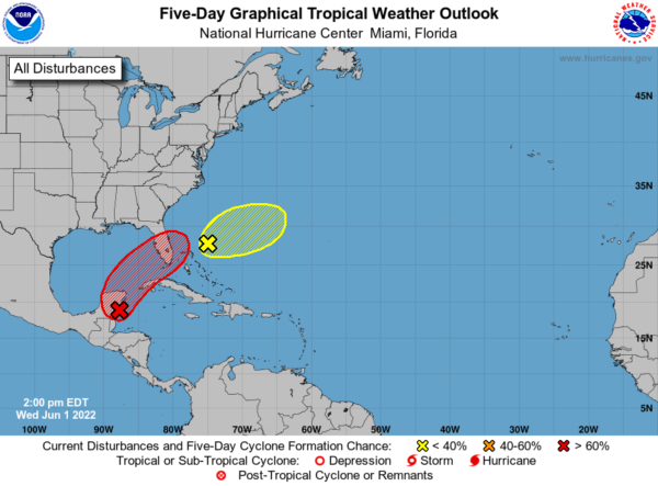
Here is the 1 pm CDT Tropical Weather Outlook from the National Hurricane Center:
• Near the Yucatán Peninsula and Southeastern Gulf of Mexico
A broad area of low pressure located near the east coast of the Yucatán Peninsula is producing a large area of disorganized showers and thunderstorms over the northwestern Caribbean Sea and Yucatán Peninsula. Despite strong upper-level winds, gradual development is forecast, and this system is likely to become a tropical depression while it moves slowly northeastward over the northwestern Caribbean Sea and southeastern Gulf of Mexico during the next day or two. Regardless of development, locally heavy rainfall is likely across portions of the Yucatán Peninsula during the next day or so, spreading across western Cuba, South Florida, and the Florida Keys on Friday and Saturday. Interests in the Yucatán Peninsula, western Cuba, the Florida Keys, and the Florida Peninsula should monitor the progress of this system.
– Formation chance through 48 hours… high… 70 percent.
– Formation chance through 5 days… high… 80 percent.
• Southwestern Atlantic, northeast of the Bahamas
A weak surface trough located about 150 miles northeast of the northwest Bahamas is producing disorganized shower activity. Surface pressures are currently high across the area, and significant development of this system appears unlikely as it moves generally east-northeastward over the next several days away from the southeastern United States.
– Formation chance through 48 hours…low…10 percent.
– Formation chance through 5 days…low…10 percent.
Category: Alabama's Weather, ALL POSTS, Tropical


