Sunday Weather Xtreme Video: Happy Mother’s Day!
Happy Mother’s Day to all our moms out there! It’s a great day to remember them and what they have given us.
A COOL START: The upper low that is northeast of us over the Mid Atlantic this morning is continuing to give us cooler temperatures. Readings this morning are in the 40s North and 50s Central and South. The wraparound clouds remained heavy over North Alabama on Saturday, even giving a Mother of Pearl look to the sky over the Birmingham area before sunset. Today, skies will be mostly sunny, with just a few lingering clouds over northeastern sections.
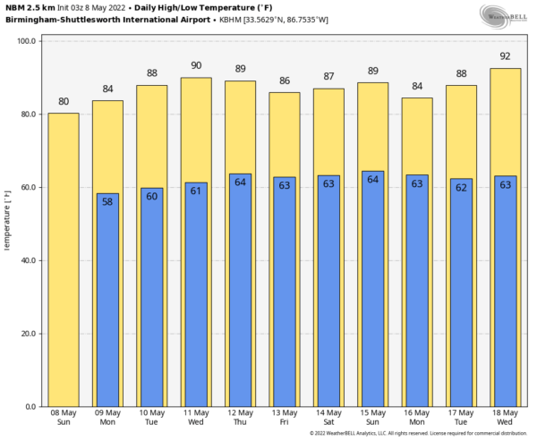
A WARM WEEK AHEAD: This morning’s cool temperatures will be but a memory as we move through the week ahead. We will start off in the middle and upper 50s tomorrow, but the mercury will rise in the lower and middle 80s by afternoon. High temperatures will rise into the upper 80s Tuesday and to near 90F by Wednesday and Thursday. Lows the remainder of the week will mainly be in the 60s.
SHOWERS FOR THE WEEKEND: Alabama will find itself increasingly caught in the squeeze between the same upper low that is near the Mid-Atlantic coast today. This low will rotate clockwise back to Florida by the weekend, spreading slightly cooler, moist air in from the northeast. Add in a front trying to approach from the northwest and we will see slowly increasing rain chances late Friday, Saturday, and Sunday. Highs will be in the middle and upper 80s.
VOODOO TERRITORY: Out in the extended part of the forecast beyond next weekend, the first part of the following week looks damp with the stubborn upper low and another right behind it keeping showers in our forecast. It is an interesting look, as we might not get out of the 60s on the 16th and 17th, but could be in the 90s three days later.
BEACHCAST: An absolutely beautiful week to be at the beach. Rain will not return to our gorgeous beaches until next weekend. Highs will be in the middle 80s each day, with lows in the middle 60s. Water temperatures are in the middle 70s. The rip current risk looks to be low over the next few days.
Click here to see the Beach Forecast Center page.
DANCING WITH THE STATS: 107F at Del Rio, Texas yesterday was a record for the date as high-temperature marks fell from Texas to Colorado. More records will fall today. The forecast of 105F at Abilene will smash their record for the date, which is 103F. Dallas is forecast for 96F, which will beat the former record of 93F.
ADVERTISE WITH US: Deliver your message to a highly engaged audience by advertising on the AlabamaWX.com website. The site enjoyed over 29 MILLION page views in the past 12 months. Don’t miss out! We can customize a creative, flexible, and affordable package that will suit your organization’s needs. Contact me, Bill Murray, at (205) 687-0782 and let’s talk.
WEATHERBRAINS: This week, the panel will entertain Eric Sorensen, a meteorologist who is running for Congress. . Check out the show at www.WeatherBrains.com. You can also subscribe on iTunes. You can watch the show live at live.bigbrainsmedia.com or on James’ YouTube Channel You will be able to see the show on the James Spann 24×7 weather channel on cable or directly over the air on the dot 2 feed.
ON THIS DATE IN 1933: Kentucky family of tornadoes killed 36 along a 60-mile path. The town of Tompkinsville was the hardest hit with 18 killed. Follow my weather history tweets on Twitter. I am @wxhistorian at Twitter.com.
Category: Alabama's Weather, ALL POSTS


