A Few Strong/Severe Storms Possible Later This Morning; Dry Weekend Ahead
RADAR CHECK: An MCS (Mesoscale Convective System) continues to move through far South Alabama and the Florida Panhandle early this morning with strong winds; some structural damage was associated with this line in Mobile during the pre-dawn hours. Some light rain is over East Alabama… otherwise the sky is mostly cloudy at sunrise.
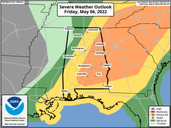
SPC maintains an “enhanced risk” (level 3/5) of severe thunderstorms for parts of East and South Alabama through early afternoon for the potential for additional development.
Here are some notes on what to expect today:
*The severe weather threat for East Alabama is somewhat conditional; it depends on how quickly the air can recover from the early morning rain and storms. There is chance the storms won’t reach severe limits until they move into Georgia.
*The best chance of severe weather in Alabama today will be along and east of I-65 (the eastern half of the state). A few showers could form over West Alabama this morning, but many places across the western half of the state will be dry today.
*The main window for strong to severe thunderstorms over East Alabama will come from 9:00 a.m. until 2:00 p.m.
*The main threat from heavier storms will come from hail and strong straight line winds. An isolated tornado can’t be totally ruled out, however, if the storms can reach severe limits.
*The storms will be out of the state by 1-2 p.m… and most of the afternoon across Alabama will be dry with a mix of sun and clouds. A few isolated showers could form tonight over the northern counties as the upper trough swings through, but nothing widespread.
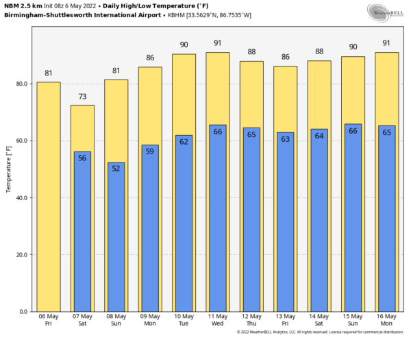
THE ALABAMA WEEKEND: The weather tomorrow will be noticeably cooler; the high will be in the 71-76 degree range with a partly sunny sky. Then, on Sunday, expect sunshine in full force with a high around 80 degrees. Some colder spots could reach the upper 40s early Sunday morning.
NEXT WEEK: Much of next week will be dry with a warming trend. Temperatures will be close to 90 degrees by Wednesday and Thursday. A few showers could show up late in the week on Friday (one week from today) as moisture increases from the east… See the Weather Xtreme video for maps, graphics, and more details.
ON THIS DATE IN 1967: An F2 tornado tore through the western part of Birmingham. A 57 year old woman who was visiting her daughter on First Court West as she watched the tornado from the front door. She was killed when 2×12 timbers launched airborne from a nearby lumber yard was hurled into the house. Birmingham Deputy Fire Chief Neal Gallant watched the storm as it tore down Lomb Avenue. A five block area near the Fairgrounds was hardest hit. The GES department store near Rickwood Field was heavily damaged. Over two dozen people were injured, and the tornado lifted just before moving into the downtown area.
ON THIS DATE IN 1975: A massive tornado hit Omaha, Nebraska killing three persons, injuring 133 others, and causing over 250 million dollars damage. The tornado struck during the late afternoon moving northeastward through the industrial and residential areas of west-central Omaha and lifting over the northern section of the city.
BEACH FORECAST: Click here to see the AlabamaWx Beach Forecast Center page.
WEATHER BRAINS: Don’t forget you can listen to our weekly 90 minute show anytime on your favorite podcast app. This is the show all about weather featuring many familiar voices, including our meteorologists here at ABC 33/40.
CONNECT: You can find me on all of the major social networks…
Look for the next Weather Xtreme video here by 3:00 this afternoon… enjoy the day!
Category: Alabama's Weather, ALL POSTS, Weather Xtreme Videos


