Mesoscale Discussion — New Severe T-Storm Watch is Unlikely
The severe weather threat for Severe Thunderstorm Watch 129 continues.
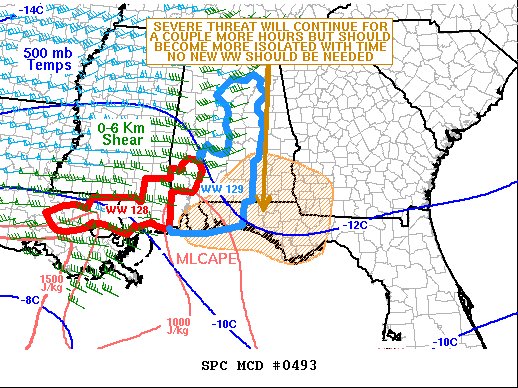
SUMMARY… The severe threat is expected to continue for a couple more hours, but should become more isolated with time. Wind damage will be the primary threat along the leading edge of the line. No new weather watch is anticipated to the east of severe thunderstorm watch 129.
DISCUSSION… The latest radar imagery out of Mobile, Alabama shows north-to-southwest oriented line of strong thunderstorms from south-central Alabama extending southward into far southern Mississippi. The storms are located in a moist airmass, where surface dewpoints are in the 65 to 70 F range, and MLCAPE is estimated to be in the 1000 to 1200 J/kg range. In addition, moderate deep-layer shear is present across much of the central Gulf Coast region. The WSR-88D VWP in southeast Alabama has 0-6 km shear near 40 knots with some directional shear in the lowest kilometer above the ground. This should be enough to maintain a wind damage threat along the leading edge of the convective line for a couple more hours. The wind damage threat should become more isolated with time as the line moves eastward into a less favorable environment.
Category: Alabama's Weather, ALL POSTS, Severe Weather
About the Author (Author Profile)
Scott Martin is an operational meteorologist, professional graphic artist, musician, husband, and father. Not only is Scott a member of the National Weather Association, but he is also the Central Alabama Chapter of the NWA president. Scott is also the co-founder of Racecast Weather, which provides forecasts for many racing series across the USA. He also supplies forecasts for the BassMaster Elite Series events including the BassMaster Classic.Subscribe
If you enjoyed this article, subscribe to receive more just like it.


