

EXPIRED — SEVERE T-STORM WARNING: Parts of Greene, Hale, Marengo, Pickens, Sumter, Tuscaloosa Co. Until 10:30 pm
The National Weather Service in Birmingham has issued a
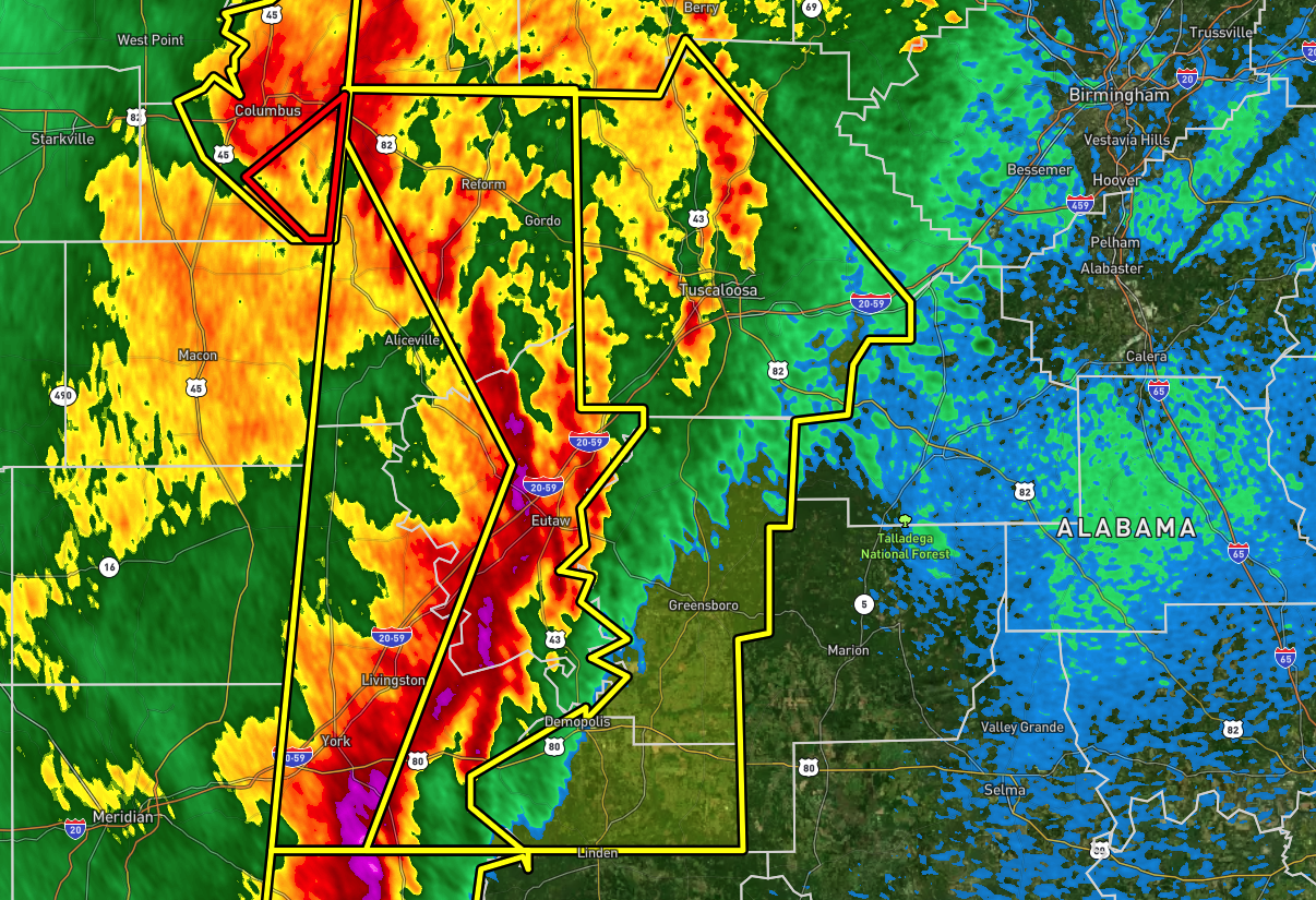
* Severe Thunderstorm Warning for…
Tuscaloosa County in west central Alabama…
Pickens County in west central Alabama…
Northern Marengo County in southwestern Alabama…
Greene County in west central Alabama…
Hale County in west central Alabama…
Southeastern Sumter County in west central Alabama…
* Until 1030 PM CDT.
* At 933 PM CDT, severe thunderstorms were located along a line
extending from near Ethelsville to near Union to near Kinterbish,
moving east at 55 mph.
HAZARD…70 mph wind gusts and penny size hail.
SOURCE…Radar indicated.
IMPACT…Expect considerable tree damage. Damage is likely to
mobile homes, roofs, and outbuildings.
* Locations impacted include…
Tuscaloosa, Northport, Demopolis, Eutaw, Greensboro, Linden, Gordo,
Reform, Carrollton, Holt, Jefferson, Moundville, Brookwood,
Coaling, Vance, Coker, Forkland, Akron, Boligee and Union.
PRECAUTIONARY/PREPAREDNESS ACTIONS…
For your protection move to an interior room on the lowest floor of a
building.
Intense thunderstorm lines can produce brief tornadoes and widespread
significant wind damage. Although a tornado is not immediately
likely, it is best to move to an interior room on the lowest floor of
a building. These storms may cause serious injury and significant
property damage.
Category: Alabama's Weather, ALL POSTS, Severe Weather
About the Author (Author Profile)
Scott Martin is an operational meteorologist, professional graphic artist, musician, husband, and father. Not only is Scott a member of the National Weather Association, but he is also the Central Alabama Chapter of the NWA president. Scott is also the co-founder of Racecast Weather, which provides forecasts for many racing series across the USA. He also supplies forecasts for the BassMaster Elite Series events including the BassMaster Classic.Subscribe
If you enjoyed this article, subscribe to receive more just like it.


