

Mesoscale Discussion — Severe Threat Continues for Locations Under Severe T-Storm Watch
The severe weather threat for Severe Thunderstorm Watch 127 continues.
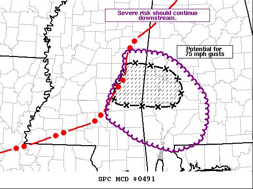
SUMMARY… A QLCS is expected to pose a risk for damaging wind gusts and isolated tornadoes as it moves to the east southeast. A corridor of enhanced damaging wind potential maybe developing with a bowing segment across eastern MS.
DISCUSSION… As of 0130z (8:30 pm), a fast moving QLCS was located across eastern MS near the border with AL. Recent reports of damaging wind gusts (some 75+ mph) have occurred with a bowing segment within the line. As the line shifts eastward into a drier low-level thermodynamic environment across western AL (dewpoints in the low 60s F), significant damaging wind potential may be developing. Hi-res guidance and observation trends suggests the southernmost portion of the line will become dominant as it slides southeastward into the corridor of better low-level moisture advection across southwestern AL. Sufficient buoyancy and vertical shear exist to support a continued severe threat with the QLCS this evening. One uncertainty remains the potential for tornadoes. While low-level shear remains fairly strong (0-1 km SRH of 100-200 m2/s2) the drier low-level environment and weaker buoyancy may favor stronger outflow and limit the potential for tornadoes with eastward extent.
Category: Alabama's Weather, ALL POSTS, Severe Weather
About the Author (Author Profile)
Scott Martin is an operational meteorologist, professional graphic artist, musician, husband, and father. Not only is Scott a member of the National Weather Association, but he is also the Central Alabama Chapter of the NWA president. Scott is also the co-founder of Racecast Weather, which provides forecasts for many racing series across the USA. He also supplies forecasts for the BassMaster Elite Series events including the BassMaster Classic.Subscribe
If you enjoyed this article, subscribe to receive more just like it.


