

Heads Up West Alabama: Dangerous Storms in Central Mississippi Heading Your Way
A strong line of storms in Mississippi extends from Tupelo to west of Philadelphia to west of Magee to west of McComb.
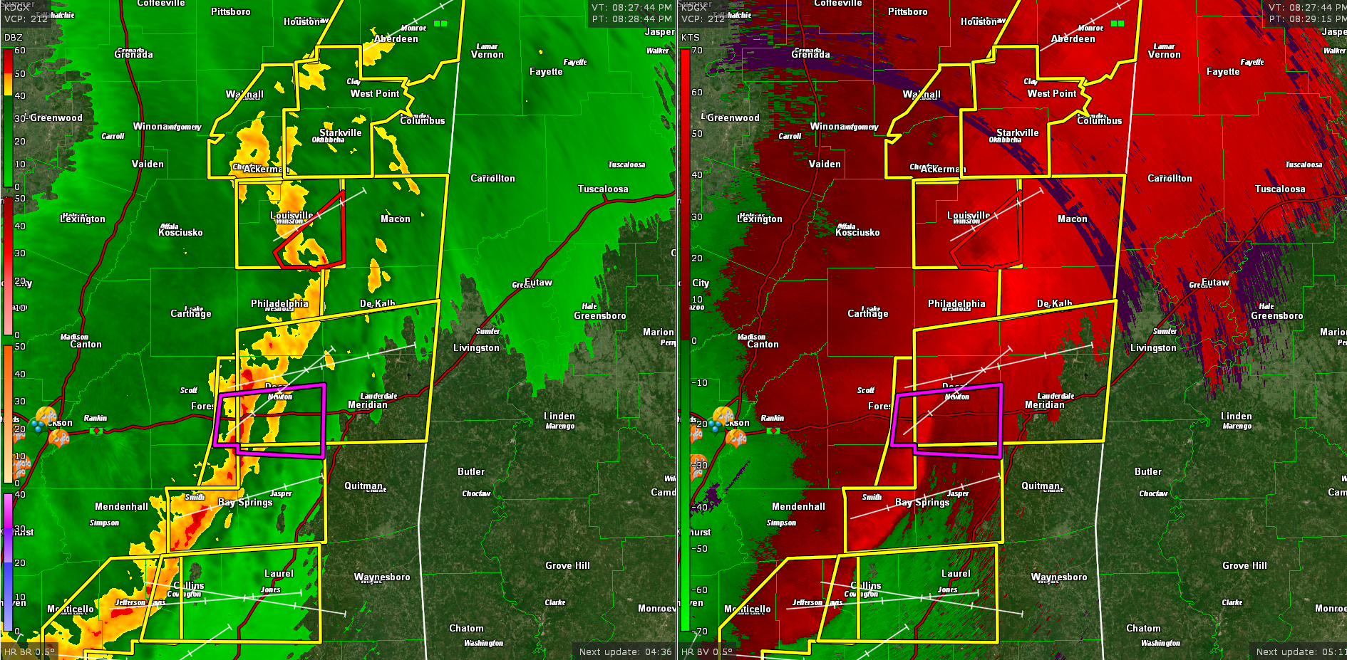
Severe thunderstorm warnings are in effect all along the line, but two areas have our main interest.
One is near Philadelphia where there is a tornado warning in effect. A new tornado warning was just issued for parts of Winston County near Noxapater. There is a definite spin evident in velocity like a mesoscale convective vortex may be forming. This would have a high potential for spin-up tornadoes as well as damaging winds. This storm is less than an hour away from northern Sumter, southern Pickens, and northern Greene Counties. This could affect Tuscaloosa before 11 p.m if it holds together.
The second area of concern is along I-20 west of Meridian. A very intense bowing segment with high winds and possible spin-up tornadoes is approaching the communities of Lake, Newton, and Hickory. This activity will arrive in Meridian in less than 45 minutes, around 9-915 p.m. A tornado warning is in effect along I-20 in Scott, Newton, northern Smith, and Jasper Counties.
There are stronger indications now of a developing tornado just west of Newton.
There were several reports of wind damage in the Jackson area.
This area of high winds and possible tornadoes will also move into Sumter, Greene, Marengo, and northern Butler Counties in western Alabama before 9:30 p.m. Dempolis will be affected, as well as Livingston, York, Cuba, Butler, Boligee, Linden, Gainesville, and Eutaw. It would eventually affect parts of Hale, Bibb, Perry, Dallas, and Wilcox.
Damaging winds of over 70 mph and spin-up tornadoes are possible. Monitor this activity carefully and be ready to move to a safe shelter in a storm shelter, well-built home, or building. Be prepared to leave manufactured homes with plenty of time to reach safe shelter.
A severe thunderstorm watch is in effect for much of West Central and Northwest Alabama until 11 p.m.
The storms are expected to slowly weaken as they approach I-65.
Stay weather aware for the next several hours. Have multiple ways to receive warnings, and a way that will wake you if you go to sleep before the storms arrive. The best bet in West Alabama would be to stay awake until the storms pass or weaken.
Category: Alabama's Weather, ALL POSTS, Severe Weather
About the Author (Author Profile)
Bill Murray is the President of The Weather Factory. He is the site's official weather historian and a weekend forecaster. He also anchors the site's severe weather coverage. Bill Murray is the proud holder of National Weather Association Digital Seal #0001 @wxhistorianSubscribe
If you enjoyed this article, subscribe to receive more just like it.


