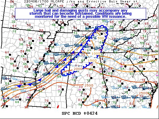
Mesoscale Discussion — Severe Thunderstorm Watch May be Needed for the Northern & Northwestern parts of the Area
A severe thunderstorm watch may be needed for the northwestern and northern parts of the area later this afternoon, as there will be a threat of damaging winds and large hail if conditions remain conducive ahead of the approaching cold front. Here is the text from the SPC:
SUMMARY… At least isolated damaging gusts/large hail may occur with the stronger storms that can become sustained along the cold front. Conditions are currently being monitored for the need of a Severe Thunderstorm Watch issuance.
DISCUSSION… A cold front continues to drift southeast as an upper low drifts towards the Great Lakes. Relatively rich low-level moisture has advected northward ahead of the front, with upper 60s F dewpoints noted as far north as the TN/AL border. 7-8 C/km mid-level lapse rates have overspread the warm sector, contributing to MLCAPE of 1000-2000 J/kg across the Southeast, decreasing to 500 J/kg into KY. CU have been steadily growing from eastern MS into northern AL. While modest deep-layer shear exists over the warm sector, the stronger low-level flow lags behind the cold front. Nonetheless, any storms that manage to become sustained and organized may achieve multicellular/transient supercell structures capable of producing damaging gusts or large hail given the aforementioned buoyancy. A WW issuance is possible over the next few hours.
Probability of Watch Issuance…40 percent
Category: Alabama's Weather, ALL POSTS, Severe Weather


