Tornado Watch Issued for Much of North/Central Alabama Until 1 am
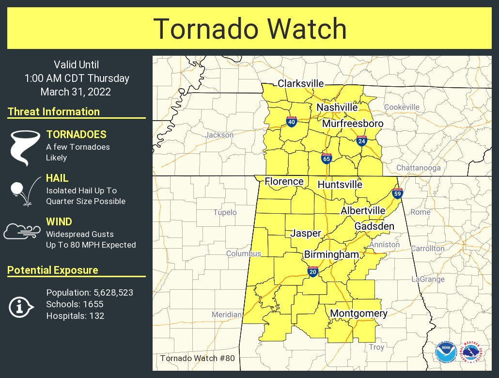
The Storm Prediction Center combined with both NWS offices in Huntsville and Birmingham have issued a TORNADO WATCH effective immediately until 1 am Thursday morning for much of North/Central Alabama.
North Alabama counties included in the watch:
Colbert, Cullman, DeKalb, Franklin, Jackson, Lauderdale, Lawrence, Limestone, Madison, Marshall, Morgan.
Central Alabama counties included in the watch:
Autauga, Bibb, Blount, Chilton, Coosa, Dallas, Elmore, Etowah, Fayette, Greene, Hale, Jefferson, Lamar, Lowndes, Marengo, Marion, Montgomery, Perry, Pickens, Shelby, St. Clair, Sumter, Talladega, Tuscaloosa, Walker, Winston.
From SPC:
SUMMARY… A fast-moving line of storms will continue quickly east-northeastward this evening into Middle TN and northern/central Alabama. Very strong low-level/deep-layer winds will support the potential for tornadoes and widespread damaging winds as additional moistening occurs into the region.
REMEMBER… A Tornado Watch means conditions are favorable for tornadoes and severe thunderstorms in and close to the watch area. Persons in these areas should be on the lookout for threatening weather conditions and listen for later statements and possible warnings.
Category: Alabama's Weather, ALL POSTS, Severe Weather
About the Author (Author Profile)
Scott Martin is an operational meteorologist, professional graphic artist, musician, husband, and father. Not only is Scott a member of the National Weather Association, but he is also the Central Alabama Chapter of the NWA president. Scott is also the co-founder of Racecast Weather, which provides forecasts for many racing series across the USA. He also supplies forecasts for the BassMaster Elite Series events including the BassMaster Classic.Subscribe
If you enjoyed this article, subscribe to receive more just like it.


