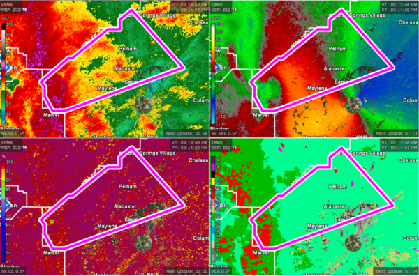
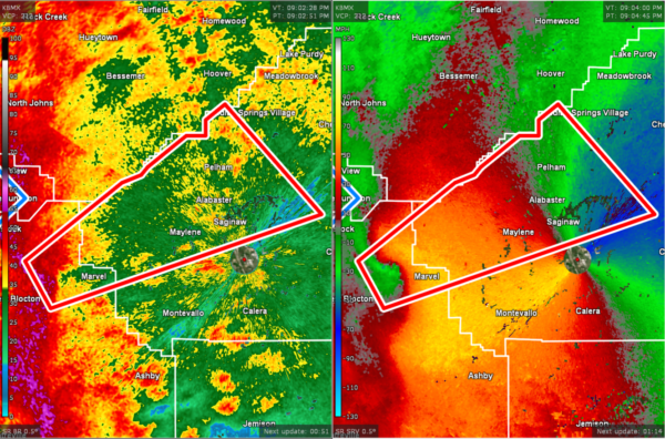
CANCELED — TORNADO WARNING: Parts of Shelby Co. Until 9:45 pm
…A TORNADO WARNING REMAINS IN EFFECT UNTIL 945 PM CDT FOR WEST
CENTRAL SHELBY COUNTY…
AT 913 PM CDT, A CONFIRMED TORNADO WAS LOCATED NEAR TANNEHILL
IRONWORKS STATE PARK, OR 9 MILES SOUTHWEST OF HELENA, MOVING
NORTHEAST AT 30 MPH.
HAZARD…DAMAGING TORNADO.
SOURCE…RADAR CONFIRMED TORNADO.
IMPACT…FLYING DEBRIS WILL BE DANGEROUS TO THOSE CAUGHT WITHOUT
SHELTER. MOBILE HOMES WILL BE DAMAGED OR DESTROYED. DAMAGE
TO ROOFS, WINDOWS, AND VEHICLES WILL OCCUR. TREE DAMAGE IS
LIKELY.
LOCATIONS IMPACTED INCLUDE…
HOOVER, ALABASTER, PELHAM, HELENA, RIVERCHASE, OAK MOUNTAIN STATE
PARK, MAYLENE, OAK MOUNTAIN AMPHITHEATER, JOE TUCKER PARK,
BALLANTRAE, SADDLE LAKE FARMS, SILURIA AND SAGINAW.
PRECAUTIONARY/PREPAREDNESS ACTIONS…
TO REPEAT, A TORNADO IS ON THE GROUND. TAKE COVER NOW! MOVE TO A
BASEMENT OR AN INTERIOR ROOM ON THE LOWEST FLOOR OF A STURDY
BUILDING. AVOID WINDOWS. IF YOU ARE OUTDOORS, IN A MOBILE HOME, OR IN
A VEHICLE, MOVE TO THE CLOSEST SUBSTANTIAL SHELTER AND PROTECT
YOURSELF FROM FLYING DEBRIS.
The National Weather Service in Birmingham has issued a
* Tornado Warning for…
West central Shelby County in central Alabama…
Northeastern Bibb County in central Alabama…
* Until 945 PM CDT.
* At 904 PM CDT, a severe thunderstorm capable of producing a tornado
was located near West Blocton, or 11 miles northwest of Montevallo,
moving northeast at 50 mph.
HAZARD…Tornado.
SOURCE…Radar indicated rotation.
IMPACT…Flying debris will be dangerous to those caught without
shelter. Mobile homes will be damaged or destroyed.
Damage to roofs, windows, and vehicles will occur. Tree
damage is likely.
* Locations impacted include…
Hoover, Alabaster, Pelham, Helena, Riverchase, Oak Mountain State
Park, Maylene, Oak Mountain Amphitheater, Joe Tucker Park,
Ballantrae, Marvel, Camp Branch, Saddle Lake Farms, Siluria,
Alabaster Veterans Park, Bounds Lake, Hebron and Saginaw.
PRECAUTIONARY/PREPAREDNESS ACTIONS…
TAKE COVER NOW! Move to a basement or an interior room on the lowest
floor of a sturdy building. Avoid windows. If you are outdoors, in a
mobile home, or in a vehicle, move to the closest substantial shelter
and protect yourself from flying debris.
Category: Alabama's Weather, ALL POSTS, Severe Weather


