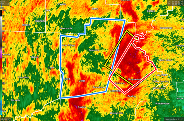
EXPIRED — FLASH FLOOD WARNING: Parts of Tuscaloosa Co. Extended Until 10:15 pm
The National Weather Service in Birmingham has extended the
* Flash Flood Warning for…
Northwestern Tuscaloosa County in west central Alabama…
* Until 1015 PM CDT.
* At 834 PM CDT, Doppler radar indicated slow moving showers and
thunderstorms producing heavy rain across the warned area. Radar
and observations indicate that 2 to locally 3 inches of rain has
already fallen with an additional 1 to 2 inches possible through
late evening. Flooding has already been reported in the city of
Tuscaloosa and near the University of Alabama Campus.
HAZARD…Flash flooding caused by thunderstorms.
SOURCE…Trained spotters reported.
IMPACT…Flash flooding of small creeks and streams, urban
areas, highways, streets and underpasses as well as
other poor drainage and low-lying areas.
* Some locations that will experience flash flooding include…
Tuscaloosa, Northport, Holt, Coker, Binion Creek Landing,
Samantha, Lake Lurleen State Park, Tuscaloosa Regional Airport,
Tuscaloosa Amphitheater, Bryant Denny Stadium, University Mall,
Tierce Pattton Bridge, Highway 69 Bridge, Lake Tuscaloosa, Sexton
Bend, Flatwoods, Echola, Buhl, Moores Bridge and Lake Nicol.
PRECAUTIONARY/PREPAREDNESS ACTIONS…
Turn around, don’t drown when encountering flooded roads. Most flood
deaths occur in vehicles.
The National Weather Service in Birmingham has issued a
* Flash Flood Warning for…
Northwestern Tuscaloosa County in west central Alabama…
* Until 915 PM CDT.
* At 721 PM CDT, Doppler radar indicated slow moving thunderstorms
producing heavy rain across portions of Tuscaloosa County. Flash
flooding is ongoing or expected to begin shortly.
HAZARD…Flash flooding caused by thunderstorms.
SOURCE…Radar.
IMPACT…Flash flooding of small creeks and streams, urban
areas, highways, streets and underpasses as well as
other poor drainage and low-lying areas.
* Some locations that will experience flash flooding include…
Tuscaloosa, Northport, Holt, Coker, Binion Creek Landing,
Samantha, Lake Lurleen State Park, Tuscaloosa Regional Airport,
Tuscaloosa Amphitheater, Bryant Denny Stadium, University Mall,
Tierce Pattton Bridge, Highway 69 Bridge, Lake Tuscaloosa, Sexton
Bend, Flatwoods, Echola, Buhl, Moores Bridge and Lake Nicol.
PRECAUTIONARY/PREPAREDNESS ACTIONS…
Turn around, don’t drown when encountering flooded roads. Most flood
deaths occur in vehicles.
Category: Alabama's Weather, ALL POSTS


