Latest Mesoscale Discussion — Damaging Winds & A Couple Tornadoes Remain Possible Over the Next Few Hours
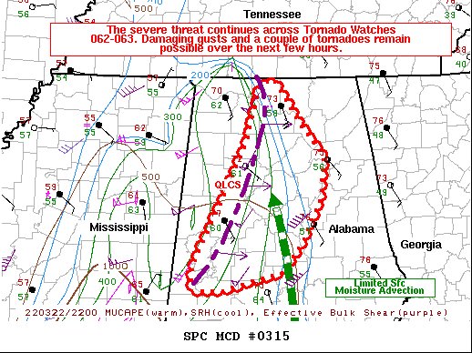
SUMMARY… The severe threat continues across Tornado Watches 062-063. Damaging gusts may accompany the stronger bowing segments, and a tornado may also occur with the more sustained supercell structures.
DISCUSSION… A broken QLCS with a history of damaging gusts and tornadoes continues to progress toward central Alabama. The line consists of both bowing segments and semi-discrete, transient supercell structures per MRMS mosaic and KBMX radar data. While low-level moisture continues to advect ahead of the line, the latest surface observations suggest that the QLCS is gradually outpacing the eastward advection of better moisture (i.e. 65+ F surface dewpoints) and resultant buoyancy (500+ J/kg MLCAPE). As such, the overall robustness of the severe wind/tornado threat remains in question. Nonetheless, BMX and MXX VWPs have recently shown very large, curved hodographs, depicting very strong low-level shear capable of supporting damaging gusts and tornadoes. On balance, an appreciable severe threat remains in the current low-CAPE/high shear environment, and a few more damaging gusts/a couple of tornadoes remain possible into early evening.
Category: ALL POSTS
About the Author (Author Profile)
Scott Martin is an operational meteorologist, professional graphic artist, musician, husband, and father. Not only is Scott a member of the National Weather Association, but he is also the Central Alabama Chapter of the NWA president. Scott is also the co-founder of Racecast Weather, which provides forecasts for many racing series across the USA. He also supplies forecasts for the BassMaster Elite Series events including the BassMaster Classic.Subscribe
If you enjoyed this article, subscribe to receive more just like it.


