

Tornado Watch Has Been Issued for All Western Counties Until 7 pm
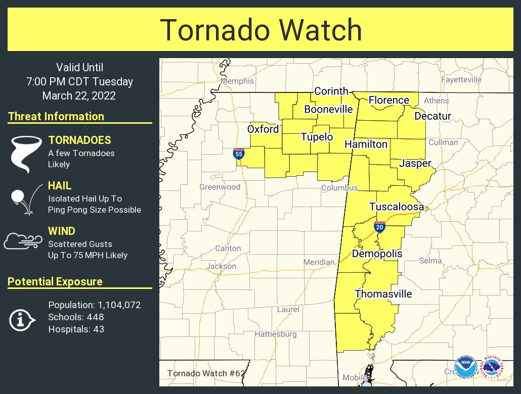
The Storm Prediction Center has issued a Tornado Watch effective immediately and is set to expire at 7 pm this evening for Fayette, Greene, Hale, Lamar, Marengo, Marion, Pickens, Sumter, Tuscaloosa, Walker, and Winston counties in Central Alabama, and for Colbert, Franklin, Lauderdale, and Lawrence counties in North Alabama.
• A few tornadoes are likely
• Isolated hail up to ping pong size possible
• Scattered damaging wind gusts up to 75 mph likely
The NWS Storm Prediction Center has issued a
* Tornado Watch for portions of
Western and northern Alabama
Northeast Mississippi
* Effective this Tuesday afternoon and evening from 1240 PM until
700 PM CDT.
* Primary threats include…
A few tornadoes likely with a couple intense tornadoes possible
Scattered damaging winds likely with isolated significant gusts
to 75 mph possible
Isolated large hail events to 1.5 inches in diameter possible
SUMMARY… A well-organized/fast-moving linear cluster of storms will
continue east-northeastward into northeast Mississippi and
western/northern Alabama as the downstream air mass otherwise
continues to moisten and destabilize. A few semi-discrete supercells
could also form ahead of this line of storms, which would
potentially pose a heightened tornado risk, perhaps especially
across far western Alabama this afternoon.
Category: Alabama's Weather, ALL POSTS, Severe Weather
About the Author (Author Profile)
Scott Martin is an operational meteorologist, professional graphic artist, musician, husband, and father. Not only is Scott a member of the National Weather Association, but he is also the Central Alabama Chapter of the NWA president. Scott is also the co-founder of Racecast Weather, which provides forecasts for many racing series across the USA. He also supplies forecasts for the BassMaster Elite Series events including the BassMaster Classic.Subscribe
If you enjoyed this article, subscribe to receive more just like it.


