Sunday Evening Update — Great Day Today; Rain & Storms Move In for the Work Week Ahead
After a brilliant day across Central Alabama with mainly sunny skies and very comfortable temperatures, the unfortunate news is that we’ll have to put up with some rain throughout the workweek ahead. For the northern half of the area, enough rain to cause some flooding issues. Here is a list of high temperatures for the main reporting stations from across Central Alabama:
Anniston … 66º
Auburn … 65º
Birmingham … 66º
Calera … 68º
Montgomery … 70º
Troy … 71º
Tuscaloosa … 68ºF
REST OF TONIGHT: Clouds will be on the increase from west to east across the area throughout the remainder of the night, while a few showers will move into the extreme west and southwestern parts of the area during the overnight hours. With the cloud cover, those overnight lows will be a good bit warmer than what we saw earlier this morning. Lows will be in the upper 30s to the upper 40s.
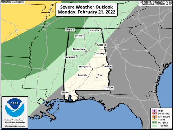
WEATHER FOR PRESIDENT’S DAY: A southwesterly flow will be set up over the area on Monday, and we’ll see showers and a few thunderstorms start to form off to our west and southwest and expand north and northeastward into Central Alabama throughout the day as a warm front will be lifting northward. The better chance for thunderstorms will be along and west of the I-59 corridor.
There is a Marginal Risk for severe storms up for the northwest corner of the state, as damaging wind gusts up to 60 mph will be possible. The Marginal Risk covers the locations along and west of a line from Vernon to Phil Campbell to Lexington. East of the I-59 corridor, much, if not all of the activity will be just general showers. Highs will be in the lower 60s to the lower 70s.
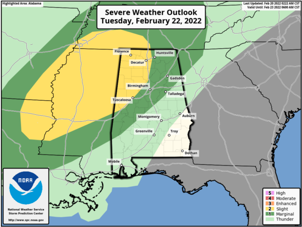
SEVERE THREAT CONTINUES INTO TUESDAY: We’ll continue to have clusters of showers and thunderstorms move across the area on Tuesday, especially during the late afternoon through the evening hours, ahead of an approaching cold front, with most of the activity taking place over the northwestern half of the area. Once again, we could see a couple of strong to severe storms with damaging winds as the main threat, with a small possibility of a brief tornado or two.
The SPC has a Slight Risk up for locations along and west of a line from Livingston to Warrior to Madison. A Marginal Risk is up outside of that to a line stretching from Sweet Water to Thorsby to just east of Piedmont.
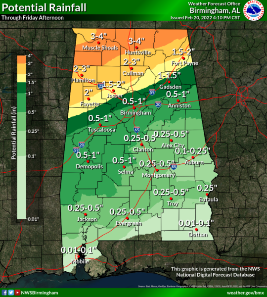
We’ll also have to watch for some flooding issues over the northern half of the area, as rainfall will be heavy at times. Highs will be in the lower 70s to the lower 80s across the area.
POTENTIAL FLOODING ISSUES: As mentioned a few times earlier in the post, heavier rain and thunderstorms will mainly be set up over the northern half of the area, where we could see totals ranging from 2-4 inches through Friday afternoon mainly north of a line from Fayette to Hanceville to Fort Payne. Some localized amounts may even be higher. The good news for the rest of the area is that amounts will be much smaller, ranging from 0.25 inches in the southeastern parts of the area to as high as 1-1.5 inches north of the I-20 corridor.
We’ll keep you updated throughout the week ahead.
Category: Alabama's Weather, ALL POSTS, Severe Weather


