Mesoscale Discussion — Severe Threat Continues for Central Parts of Central Alabama
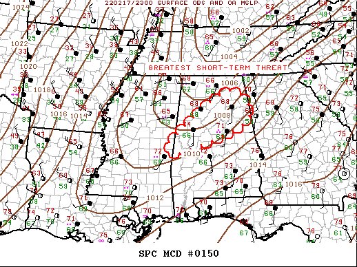
SUMMARY… Severe threat continues along/ahead of the cold front, likely concentrating along a corridor from east-central MS to northeast AL. Along with a supercell tornado threat, damaging winds remain possible with the squall line.
DISCUSSION… Several pre-frontal supercells continue this evening, mostly across central AL, roughly 25-30mi ahead of the squall line. This activity is spreading quickly northeast into a region that is less buoyant but likely moist enough to maintain ongoing convection, at least for the next several hours. Frontal convection (squall line) will be the dominant storm mode the rest of tonight as the wind shift continues advancing east in conjunction with the ejecting short wave. Some tornado threat remains, especially with the supercells, for the next few hours, but damaging winds will become the main threat with the squall line.
Category: Alabama's Weather, ALL POSTS, Severe Weather
About the Author (Author Profile)
Scott Martin is an operational meteorologist, professional graphic artist, musician, husband, and father. Not only is Scott a member of the National Weather Association, but he is also the Central Alabama Chapter of the NWA president. Scott is also the co-founder of Racecast Weather, which provides forecasts for many racing series across the USA. He also supplies forecasts for the BassMaster Elite Series events including the BassMaster Classic.Subscribe
If you enjoyed this article, subscribe to receive more just like it.


