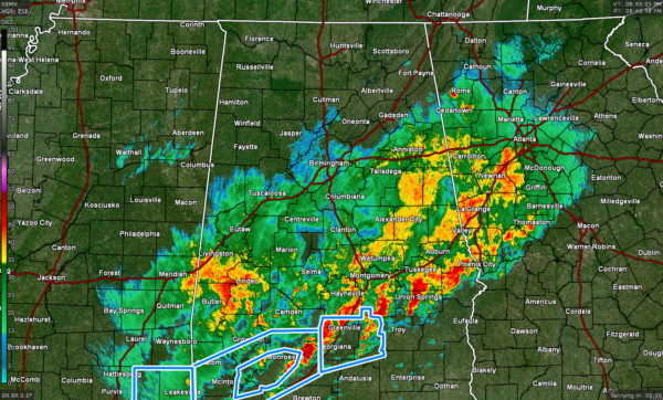
Severe Threat Has Ended for the Most Part; Tornado Watch has Finally Expired
As of 8:43 pm, the line of storms have pushed into the extreme southeastern parts of Central Alabama moving through portions of Russell, Bullock, and Montgomery counties, and will soon push into Pike and Barbour counties. Behind that leading edge of storms, there is still a shield of light to moderate showers stretching west and north all of the way up to the I-20 corridor, with a patch of heavy rain falling over portions of Marengo and Sumter counties.
The good news is that the Tornado Watch was allowed to expire, and no severe weather watches remain in effect. However, there remains a small threat of flash flooding, mainly along and south of the I-85 corridor tonight, until the heavier storms on the leading edge of the line moves out of the area and into southwestern portions of Georgia. With that being said, a Flood Watch does continue until 6 am Friday morning for Autauga, Bibb, Calhoun, Chambers, Chilton, Clay, Cleburne, Coosa, Dallas, Elmore, Lee, Lowndes, Macon, Montgomery, Perry, Randolph, Shelby, Talladega, and Tallapoosa counties in Central Alabama. The Flood Watch for Cullman, DeKalb, Jackson, Madison, Marshall, and Morgan counties in North Alabama will expire at 9 pm tonight.
There is still a wide range of temperatures across the area, as it is at 70º down in Eufaula, but it is all of the way down to 36º in Haleyville. Birmingham was at 48º. Overnight lows from northwest to southeast will drop into the lower 30s to the lower 50s. Don’t expect it to warm up too much on Friday as highs will only be in the upper 30s to the lower 60s, with many of those high temperatures in the southeastern quarter of the area most likely occurring at midnight tonight.
We still have a very small threat of freezing drizzle over the northwestern corner of the area during the pre-dawn hours, especially west of a line from Vernon (Lamar Co.) to Double Springs (Winston Co.) to Lexington (Lauderdale Co.). A light glaze of ice is possible, which may make bridges and overpasses slippery during that window of time in those locations.
Category: Alabama's Weather, ALL POSTS, Severe Weather


