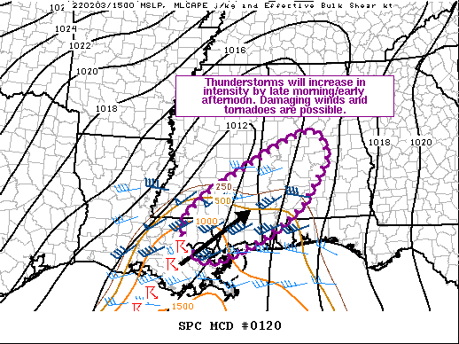
Mesoscale Discussion — Watch Likely to Be Issued for Portions of Central Alabama
Storms have developed in southeastern Louisiana and will continue eastward today. Modest destabilization and strong shear will support organized storms capable of damaging winds and tornadoes. A watch is likely by early afternoon. Here is the latest discussion from the Storm Prediction Center:
A line of pre-frontal thunderstorms has developed within the last 30 minutes west of Lake Pontchartrain. Other discrete storms have developed along the Mississippi/Alabama Gulf Coast and shown some rotation before weakening as they move inland. Warm/moist air continues to advect northward ahead of this activity, as the surface low will steadily migrate northeastward through the Tennessee Valley today. Based on this morning’s observed and model forecast soundings, it appears that temperatures will have to reach the low 70s F for storms to become surface based. At least muted surface heating south of greater mid/high-level clouds in northern Mississippi and northern Alabama should support this by early afternoon. MLCAPE of 500-1000 J/kg and 35-50 kts of effective shear (values increasing from south to north) will support organized storms. Along with damaging winds, a threat for tornadoes will exist given the strong low-level veering present in regional WSR-88D VAD profiles. Storm mode will predominantly be clusters and quasi-linear segments. Discrete storms within the warm sector would pose a greater tornado threat, but lack of stronger surface heating and low-level forcing decrease confidence in this possibility. A watch will likely be needed by early afternoon.
Category: Alabama's Weather, ALL POSTS, Severe Weather


