Cloudy With Scattered Showers Out There as We Approach the Midday Hour
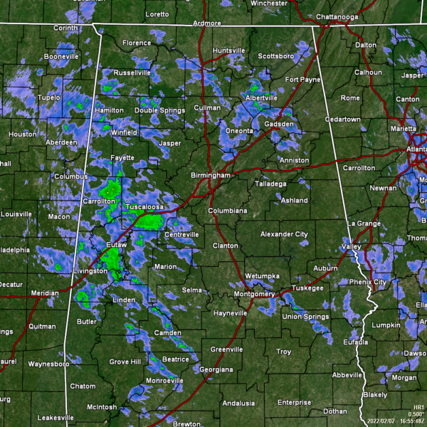
CONDITIONS AS OF 11 AM
While it is cloudy across much of the area, with scattered to numerous showers occurring over a good portion of Central Alabama, we do see some sunshine reaching the surface down in the extreme southeastern portions of the area. The good news is that none of the shower activity is heavy at this point, but that will begin to change as we move into the late night and overnight hours. Temperatures were in the lower 50s to the upper 60s across the area. Troy was the warm spot at 67º. Haleyville was the cool spot at 50º. Birmingham was sitting at 59º.
REST OF TODAY
We’ll continue to stay cloudy across the area, with showers remaining likely at times, especially along and north of I-85. No strong storms are expected for today. It will be quite mild out there, as highs will reach the upper 50s to the lower 70s across the area from northwest to southeast. For tonight, rain and a few rumbles will be likely at times across most of the area, with some of the rainfall becoming heavy at times. We may see a few flash flooding issues occur during the overnight hours. Lows will only fall into the mid 50s to the lower 60s across the area.
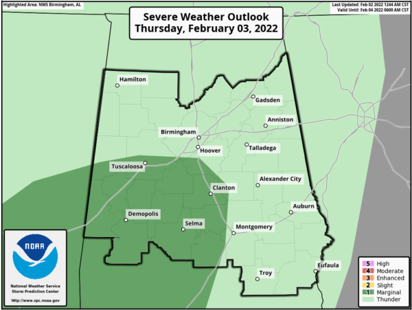
MARGINAL RISK UP FOR PARTS OF CENTRAL ALABAMA ON THURSDAY
Rain and thunderstorms will continue across the area, with the rainfall being heavy at times. A few strong to severe storms may be possible over the south and southwestern parts of the area during the afternoon and into the early evening hours. Locations south and west of a line from Carrollton to Pelham to Deatsville to Fort Deposit have been placed in a Marginal Risk (level 1/5) for the threat of isolated damaging wind gusts up to 60 mph, mainly from 12 pm Thursday afternoon to roughly 6 pm Thursday evening. It will be even warmer, with highs reaching the lower 60s to the mid 70s across the area from northwest to southeast.
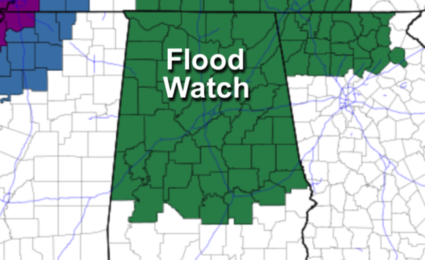
FLOOD WATCH FROM MIDNIGHT TONIGHT THROUGH 6 AM FRIDAY MORNING
With the system that is currently affecting the area and not expected to move out until Friday morning, we have the potential of picking up enough rainfall that some flooding issues may occur. We could receive up to 2-4 inches of rainfall across North/Central Alabama, with the highest amounts occurring north of the I-20 corridor.
Central Alabama counties included in the watch: Autauga, Bibb, Blount, Calhoun, Chambers, Cherokee, Chilton, Clay, Cleburne, Coosa, Dallas, Elmore, Etowah, Fayette, Greene, Hale, Jefferson, Lamar, Lee, Lowndes, Macon, Marengo, Marion, Montgomery, Perry, Pickens, Randolph, Shelby, St. Clair, Sumter, Talladega, Tallapoosa, Tuscaloosa, Walker, and Winston.
North Alabama counties included in the watch: Colbert, Cullman, DeKalb, Franklin, Jackson, Lauderdale, Lawrence, Limestone, Madison, Marshall, and Morgan.
FRIDAY & THE WEEKEND
Rain and storms will be moving out of the state on Friday, but cold air will be moving in on it’s coat tails. Highs will be in the upper 30s to the lower 60s from northwest to southeast. We’ll continue to keep clouds in the forecast for Saturday, and there may be just enough moisture for a few sprinkles, but odds for that occurring are very low for now. Highs will be in the mid 40s to the mid 50s. Sunday will feature clearing skies, with highs back up in the 50s across the area.
NEXT WEEK
Next week looks to be a cool and dry week across Central Alabama, with highs mainly in the 50s and lows in the 30s. But, someone says we are not through with winter weather yet…
SIX MORE WEEKS OF WINTER WEATHER
Ole Punxsutawney Phil saw his shadow earlier this morning, and according to the old weather folklore, there will be six more weeks of winter weather. In case you are wondering about Birmingham’s prognosticator at the Birmingham Zoo, Birmingham Bill, he decided to spend this Groundhog’s Day sleeping. That’s right, he is still hibernating. So, I guess we’ll have to rely on Phil’s word for 2022.
Category: Alabama's Weather, ALL POSTS, Severe Weather


