SPC Mesoscale Discussion — Tornado Potential Increasing Over Southwest & South-Central Alabama
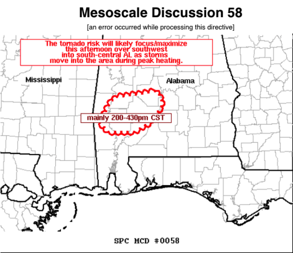
The latest Mesoscale Discussion just put out by the SPC mentions that the stronger cells moving out of Mississippi into the southwestern parts of Alabama may pose an increased threat for tornadoes as more moisture-rich air continues to move up into the area. Here is the text from the discussion:
SUMMARY… The tornado risk will likely focus/maximize this afternoon over southwest into south-central AL as storms move east into the area during peak heating while maintaining quasi-discrete structure.
DISCUSSION… Radar imagery shows a squall line early this afternoon over central AL with a broken band of quasi-discrete updrafts farther southwest into southeast MS moving east into parts of southwest AL. The northward advection of richer low-level moisture (surface dewpoints rising into the mid 60s F) will combine with modest heating to yield appreciable buoyancy for strong updraft development. The stronger updrafts over southeast MS are supercellular and will likely maintain a quasi-discrete storm mode due to the lack of stronger forcing promoting quick upscale growth. Furthermore, it seems the developing supercells in southeast MS will intensify further during peak heating and likely reach a mature phase over southwest AL into south-central AL. The risk for a tornado will correspondingly increase and maximize in the vicinity of the I-65 corridor in southwest AL east-northeastward to the west of Montgomery during the 200-430pm CST period. As storms move east of the discussion area into parts of southeast AL, uncertainty due to less-favorable convective mode and being beyond peak heating may combine to lower the tornado risk. However, convective trends will be monitored over the next few hours for the possibility for a watch extension-in-area or an additional small tornado watch to the east of tornado watch #14 in parts of southeast AL.
Category: Alabama's Weather, ALL POSTS, Severe Weather


