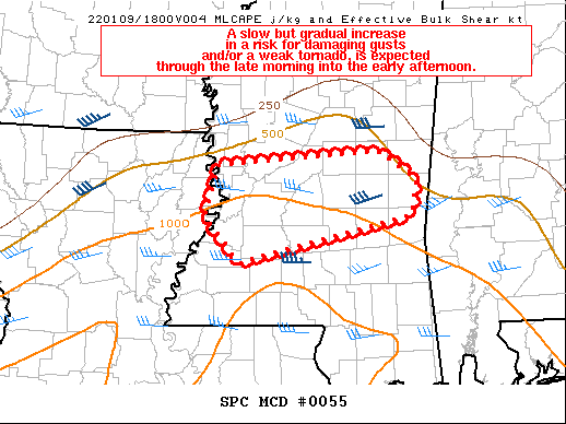
SPC Mesoscale Discussion: Severe Weather Threat Slowly Increasing Across Mississippi into Western Alabama
An area of thunderstorms is moving across Central Mississippi at this hour. The I-29 Corridor from Jackson to Meridian will be the focus for the potential for severe weather over the next couple of hours. The SPC did say that a tornado watch was possible and the risk of damaging gusts and a brief, weak tornado is slowly increasing.
This activity will move into western Alabama after noon today.
Right now across Alabama, clouds are thick. Temperatures are mostly still in the 50s, as are the dewpoints. This will change in coming hours as temperatures warm into the 60s to near 70F, and dewpoints rise into the lower 60s to near 65F. This will allow for enough destabilization for stronger storms to develop.
Mesoscale Discussion 0055
NWS Storm Prediction Center Norman OK
0941 AM CST Sun Jan 09 2022
Areas affected…central MS
Concerning…Severe potential…Watch possible
Valid 091541Z – 091815Z
Probability of Watch Issuance…40 percent
SUMMARY…A slow but gradual increase in a risk for damaging gusts
and/or a brief/weak tornado, is expected through the late morning
into the early afternoon. The corresponding need for a possible
tornado watch will correspondingly increase, but largely be dictated
by storm-term observational trends over the next several hours.
DISCUSSION…Radar imagery shows a couple of organized but transient
storm structures over west-central MS this morning. This area of
convection is near but to the north and northeast of richer
low-level moisture characterized by upper 60s F dewpoints over
central LA and southern MS to the south of I-20. Continued
low-level moisture advection will lead to some weak destabilization
over east-central MS where buoyancy is currently limited as of mid
morning. A weak mid-level shortwave trough will continue eastward
across the lower MS Valley today and will at least marginally
support some focus for thunderstorm activity from near the MS River
east into parts of western AL later today. The development of weak
surface-based destabilization resulting in 250-1000 J/kg MLCAPE will
offer a conditional risk for isolated instances of low CAPE/high
shear supercells. The increase in mid-level flow associated with
the aforementioned mid-level disturbance is already being sampled by
the KDGX VAD during the past few hours. As such, a gradual increase
in the risk for organized storms and an associated isolated severe
threat is expected.
..Smith/Hart.. 01/09/2022
Category: Alabama's Weather, ALL POSTS, Severe Weather


