A Quick Look at What to Expect for the Rest of Your Thursday

A surface boundary continues to slip southward across the southern portions of Central Alabama, with a line of rain and a few stronger thunderstorms. For now, no severe weather watches or warnings are in effect for the area, but we still have a risk for severe storms through this evening across the extreme southern and southeastern parts of the area.
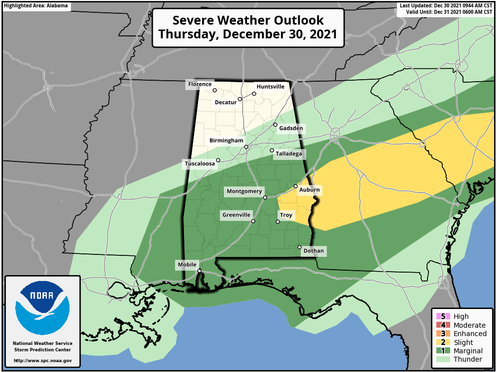
For now, a Slight Risk for severe storms remain in effect for locations along and east of a line from Opelika to Shorter to Linwood to just north of Texasville. A marginal Risk is up for much of the rest of the southern half of Central Alabama along and south of a line from Boligee to Columbiana to just south of Ranburne; however, if you are north of the line of storms at this point, the severe weather threat is over for today.
For those remaining along and ahead of the line of storms, there is a threat of damaging winds up to 60 mph, quarter-size hail, and a much smaller threat of a tornado or two. The timing will have the severe weather threat ending for the locations along and north of the I-85 and US-80 corridors by 3 pm, and south of that to the Georgia state line and the southern borders of Pike and Barbour counties by 6 pm tonight.
For the evening and overnight hours, there will only be a very slight chance of a few showers across much of Central Alabama, except for slightly better rain chances with a rumble of thunder or two along and south of the I-85 corridor. Patchy fog will develop across portions of the area after midnight. Lows will remain rather mild, only dropping into the mid 50s to the mid-60s across the area.
Category: Alabama's Weather, ALL POSTS, Severe Weather
About the Author (Author Profile)
Scott Martin is an operational meteorologist, professional graphic artist, musician, husband, and father. Not only is Scott a member of the National Weather Association, but he is also the Central Alabama Chapter of the NWA president. Scott is also the co-founder of Racecast Weather, which provides forecasts for many racing series across the USA. He also supplies forecasts for the BassMaster Elite Series events including the BassMaster Classic.Subscribe
If you enjoyed this article, subscribe to receive more just like it.


