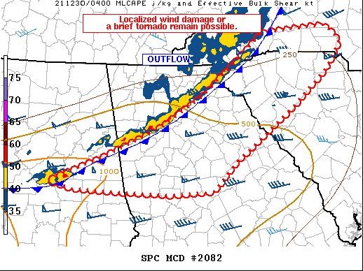
Latest Mesoscale Discussion from the SPC
The severe weather threat for Tornado Watch 571 continues.
SUMMARY… Isolated reports of damaging gusts or a brief tornado remain possible across the watch area as a line of storms pushes east tonight.
DISCUSSION… A line of storms currently stretches from northwestern SC across northern GA and into central AL, where a lone supercell produced a tornado earlier. Northern portions of the outflow are mainly producing rain showers into western NC, but an uptick in intensity with this portion of the line cannot be ruled out as it intercepts lower 60s F dewpoints.
To the southwest, the strongest portion of the line continues to move across northern GA with relatively laminar outflow currently. The orientation of this line is becoming more parallel with the deep-layer shear, which is not particularly favorable for forward acceleration. However, shear remains favorable for supercells, and a brief QLCS tornado remains possible along the line. The greatest instability will remain farther west into AL, with MLCAPE over 1000 J/kg, with around 250 m2/s2 effective SRH still favoring supercells.
Category: Alabama's Weather, ALL POSTS, Severe Weather


