More Counties Likely to Be Added to the Tornado Watch This Evening
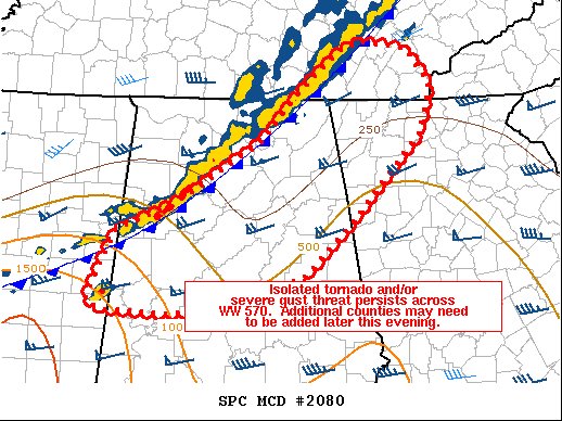
A cold front is now working across the north and northwestern parts of North/Central Alabama, with conditions remaining primed for the potential of severe storms. The latest Mesoscale Discussion from the SPC shows that the tornado watch currently in effect may be expanded further to the east and south later this evening. Here is the latest from the SPC:
SUMMARY… Isolated tornado or damaging wind threat remains across
the region. Convective trends are being closely monitored across
central Alabama.
DISCUSSION… A line of storms continues to push east across TN into northern AL and east-central MS, primarily displaying a solid gust front but with periodic surges of wind and rotation in QLCS fashion. A lone supercell was noted near the MS/AL border southwest of TCL, and this storm will cross into AL shortly.
The environment ahead of the squall line continues to favor a rapid eastward motion, given strong west/southwest flow aloft. Instability becomes quite marginal to support severe toward the TN area, but a bit of warm advection may yet support isolated reports into northern GA and southeast TN.
Some moistening may aid minor destabilization across central AL this evening given the veered nature of the 850 mb winds, and modest effective SRH conditionally favors a supercell threat. As such, the area from central AL into western GA will need to be monitored for potential watch extension or new issuance.
Category: Alabama's Weather, ALL POSTS, Severe Weather
About the Author (Author Profile)
Scott Martin is an operational meteorologist, professional graphic artist, musician, husband, and father. Not only is Scott a member of the National Weather Association, but he is also the Central Alabama Chapter of the NWA president. Scott is also the co-founder of Racecast Weather, which provides forecasts for many racing series across the USA. He also supplies forecasts for the BassMaster Elite Series events including the BassMaster Classic.Subscribe
If you enjoyed this article, subscribe to receive more just like it.


