SPC Expands Enhanced Risk Again, While Reducing the Slight Risk Slightly
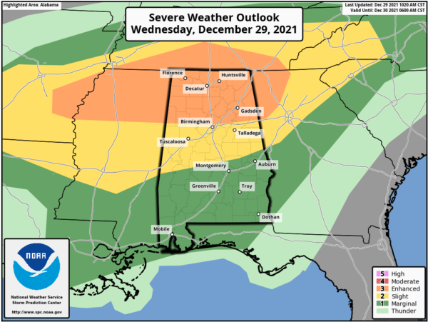
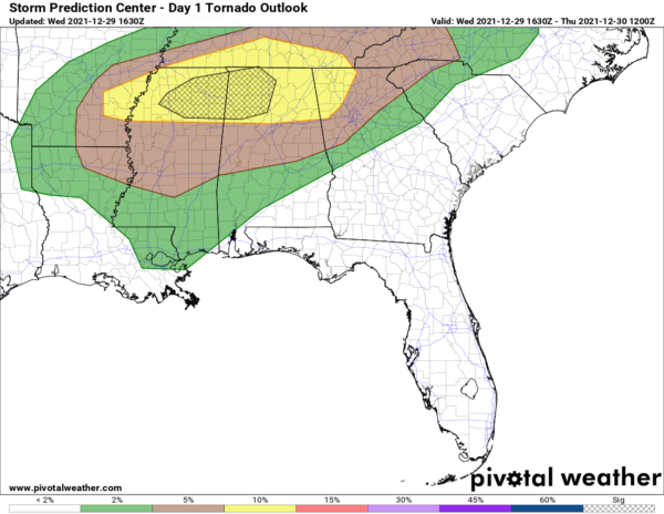
I know it has literally been just a few minutes since I posted about the expansion of risk levels across North/Central Alabama, but I’m back again as the Storm Prediction Center has just updated the risk levels once again for the area, and has introduced an increased risk for tornadoes for locations west of I-65.
ENHANCED RISK: Includes all counties in North Alabama and stretches into Central Alabama as far south as a line stretching from Millport to just north of Birmingham to Heflin.
SLIGHT RISK: Has been reduced slightly in the southern parts of the area and now stretches to the south to a line from Uniontown to Deatsville to just south of Lafayette.
MARGINAL RISK: Now includes the rest of the southern parts of Central Alabama south of a line from Uniontown to Deatsville to just south of Lafayette.
The hatched area for the higher tornado risk include much of the northwestern parts of North/Central Alabama, including the cities of Athens, Decatur, Hartselle, Cullman, Florence, Russellville, Double Springs, Hamilton, Haleyville, Jasper, Fayette, and Vernon. Here is the text from the latest update…
SUMMARY: Tornadoes, damaging thunderstorm gusts and isolated large hail are possible from parts of the lower Mississippi Valley into the Tennessee Valley and southern Appalachians vicinity through tonight.
AR/LA into TN Valley: Ongoing forecast remains on track with only minor changes. Intense thunderstorms are expected to develop by early afternoon over southern AR as a combination of daytime heating, approaching large scale ascent, and strengthening wind fields overspread the region. This cluster of storms will organize and track across the ENH risk corridor through the afternoon and evening hours. A few supercells are possible, as well as an increasing risk of a larger-scale bowing structures as storms move into middle TN, northeast MS, northern AL, and eventually into northwest GA. Tornadoes, damaging winds, and hail will all be possible with these storms. Have also added a small corridor of 10% significant tornado probabilities over parts of MS/AL where CAM guidance and forecast shear profiles appear most favorable. Please refer to MCD #2070 for further short-term details.
Farther south, more isolated thunderstorm development is expected later this afternoon and evening across central MS/AL. This area will have favorable vertical shear profiles and CAPE for discrete supercells and some risk of tornadoes. However, large-scale forcing is weaker, so uncertainty is lower regarding coverage and intensity of storms.
Category: Alabama's Weather, ALL POSTS, Severe Weather


