SPC Expands Enhanced & Slight Risks for Severe Storms
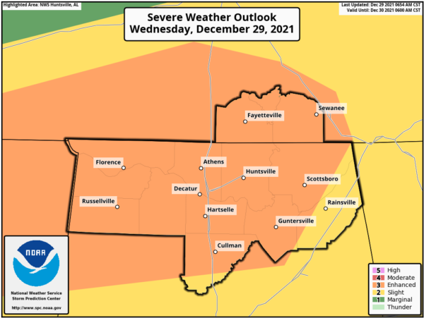
NWS Birmingham has stated that models are trending toward higher instability and shear rates across the northwestern parts of the area later this afternoon and into the early evening hours, which may lead to the enhancement of any storms that begin to rotate. Therefore, the need for the expansion of the Enhanced Risk farther into the north and northwestern parts of Central Alabama. Also, forcing is expected to be a little better in much of North Alabama, and that has also called for the expansion of the Enhanced Risk further into the eastern parts of the area. Here are the latest updates from the Storm Prediction Center:
The Storm Prediction Center has expanded the Enhanced Risk for severe storms to now include nearly all of North Alabama, except for the far eastern portions of the area. The Enhanced Risk includes the cities of Florence, Russellville, Decatur, Athens, Hartselle, Cullman, Huntsville, Guntersville, and Scottsboro. A Slight Risk remains in effect for the eastern portions of North Alabama, which includes the city of Rainsville.
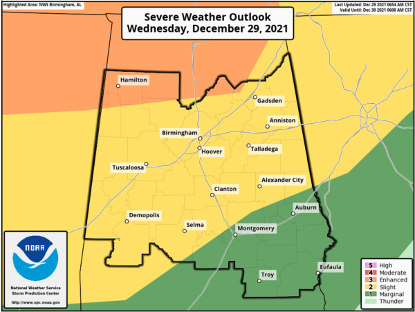
The expansion of the risk areas has now put the far north-central and northwestern parts of Central Alabama in an Enhanced Risk, including Marion and Winston counties, along with the northern parts of Lamar County, the extreme northern parts of Walker County, the northern parts of Blount County, and the extreme northwestern parts of Etowah County.
The Slight Risk expansion southward across the area now includes much of the rest of Central Alabama, including the cities of Gadsden, Anniston, Birmingham, Talladega, Hoover, Tuscaloosa, Alexander City, Clanton, Demopolis, and Selma. A Marginal Risk is up for the southeastern parts of the area, including the cities of Auburn, Montgomery, Eufaula, and Troy.
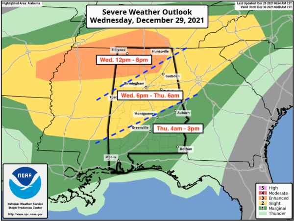
Timing for the threat of severe storms today will start around 12 pm for the north and northwestern parts of the area and will go until 8 pm for those locations. For the southwest, central, and northeast locations, the timing will be from roughly 6 pm tonight through 6 am Thursday morning. For the southeastern parts of the area, the timing will be on Thursday from roughly 4 am through 3 pm.
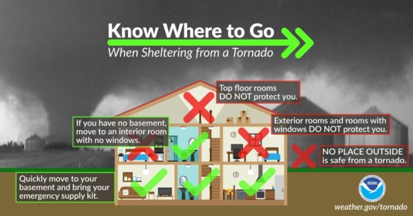
Be sure that you have multiple reliable ways to receive warnings this today and especially during the nighttime and overnight hours… and know where to go if your location goes under a warning.
Category: Alabama's Weather, ALL POSTS, Severe Weather


