Midday Nowcast: Warm Front Lifting North
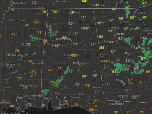
A warm front is lifting north across the state today bringing us the clouds and scattered showers, along with much warmer temperatures. At the midday hour, it is still a bit cool ahead of the front with widespread 50s and 60s, but once the front passes your location, temperatures will climb into the mid 70s with a nice southerly breeze.
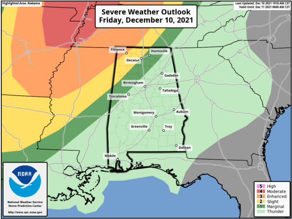
TO OUR WEST: We are watching storm development to the northwest this afternoon and tonight, where the SPC has defined a “moderate risk” (level 4/5) of severe thunderstorms from the Mississippi Delta region northward into parts of Illinois and Indiana. Storms that form in that region will become severe, some strong tornadoes are possible as a widespread severe weather event is anticipated.
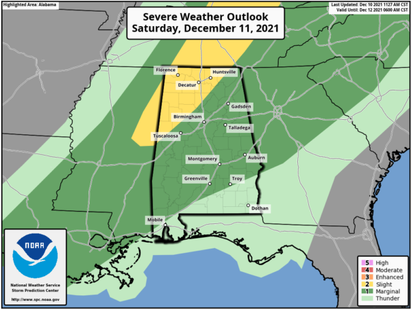
The activity northwest of Alabama is expected to evolve into a long squall line after midnight tonight, and will move into the state early tomorrow morning. SPC has defined a “slight risk” (level 2/5) as far east as Athens, Haleyville, and Millport through 6AM tomorrow morning, with a “marginal risk” (level 1/5) to Lake Guntersville and Tuscaloosa. Then, after 6AM ,the SPC has most of Alabama is in a “marginal risk” (level 1/5) for storms tomorrow, while maintaining the “slight risk” for areas north and west of Birmingham.
STORMY SATURDAY: The line will continue to drop south and east through Alabama during the morning hours, likely reaching the Birmingham/Anniston/Gadsden/Tuscaloosa areas just before noon, then continuing into the southern counties of the state by mid to late afternoon. The severe weather threat will is not as great for South Alabama as dynamic support will be weakening by then and pulling away from the state.
THREATS: For Alabama, the main threat will come from strong, potentially damaging straight line winds. A few isolated tornadoes can’t be ruled out, however. Rain will be briefly heavy, but flooding is not expected as rainfall totals should be in the ½ – 1 inch range.
CALL TO ACTION: Be sure you have a way of hearing severe weather warnings. Your primary source should NEVER be an outdoor siren. Have a NOAA Weather Radio in your home properly programmed with a fresh battery in case of power failure. Be sure emergency alerts are enabled on your phone. And, review your severe weather plan; identify the safe place and be sure everyone knows where it is. And, if you live in a mobile home, know where you will go in case you fall in a tornado warning polygon.
BEHIND THE FRONT: Temperatures will fall from the 70s early in the day into the 50s late in the day behind the front. The rain and clouds will be gone by Saturday night. Sunday will feature ample sunshine, with highs in the 50s.
BEACH FORECAST CENTER: Get the latest weather and rip current forecasts for the beaches from Fort Morgan to Panama City on our Beach Forecast Center page. There, you can select the forecast of the region that you are interested in visiting.
WORLD TEMPERATURE EXTREMES: Over the last 24 hours, the highest observation outside the U.S. was 109.4F at Telfer, Australia. The lowest observation was -70.2F at Delyankir, Russia.
CONTIGUOUS TEMPERATURE EXTREMES: Over the last 24 hours, the highest observation was 93F at Rio Grande Village, TX. The lowest observation was -16F at Estcourt Station, ME.
Category: Alabama's Weather, ALL POSTS


