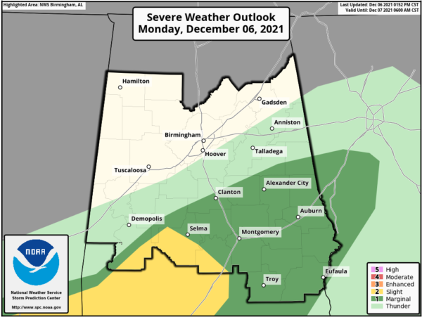
Only a Very Small Portion of Central Alabama Remains in a Slight Risk
As of the 1:52 pm update from the Storm Prediction Center, the Slight Risk for severe storms has been greatly reduced to now only include the southeastern half of Marengo County, the southern tip of Perry County, the southwestern 2/3rds of Dallas County, and the southwestern half of Lowndes County. The Marginal Risk has been slightly reduced to only include the cities of Selma, Clanton, Alexander City, Montgomery, Auburn, Troy, and Eufaula. And to tell you the truth, I believe the severe threat is over for Clanton, Alexander City, and Auburn. The rest of Central Alabama is free and clear of severe thunderstorm threats.
Just an FYI… It now looks like we’ll have another threat of severe storms back in the area on Saturday as a strong cold front will move through the area. We’ll have better details over the next few days.
Here’s the text from the latest SPC update:
SUMMARY… A few strong to severe storms are expected today over parts of Louisiana, Mississippi, and Alabama. Damaging wind gusts will be the primary hazard.
FAR SOUTHEAST TX INTO WEST-CENTRAL GA… The cold front continues to push southeastward, with recent surface analysis placing it from HOU northeastward to near BTR before becoming more wavy due to augmentation by convective outflow across MS and AL. As discussed in MCD #1969, some intensification of thunderstorm development is still possible late this afternoon, particularly across parts of south central through southeastern Alabama. This intensification may be accompanied by the risk of a few damaging wind gusts and/or a brief tornado, particularly as the storms along the front interact with any pre-frontal development. A similar situation is possible farther west across southern LA and far southern MS.
Category: Alabama's Weather, ALL POSTS, Severe Weather


