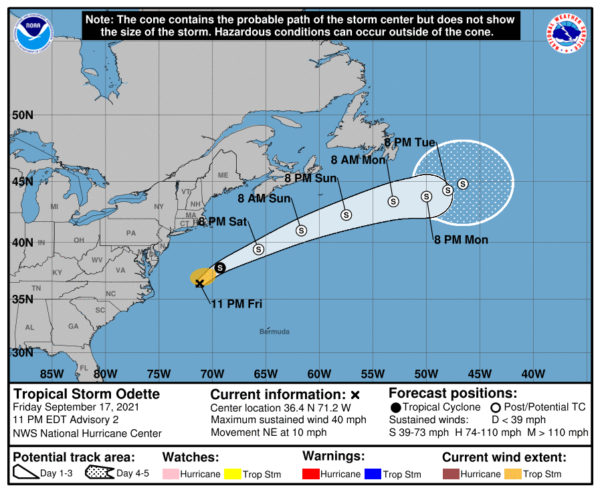
Tropical Storm Odette is Poorly Organized Off the US Mid-Atlantic Coast at 10pm
ODETTE POORLY ORGANIZED OFF THE U.S. MID-ATLANTIC COAST.
FORECAST TO BECOME POST-TROPICAL BY SATURDAY NIGHT SOUTH OF ATLANTIC CANADA.
SUMMARY OF 1100 PM EDT…0300 UTC…INFORMATION
———————————————–
LOCATION…36.4N 71.2W
ABOUT 265 MI…430 KM SE OF CAPE MAY NEW JERSEY
ABOUT 340 MI…545 KM S OF NANTUCKET MASSACHUSETTS
MAXIMUM SUSTAINED WINDS…40 MPH…65 KM/H
PRESENT MOVEMENT…NE OR 50 DEGREES AT 10 MPH…17 KM/H
MINIMUM CENTRAL PRESSURE…1010 MB…29.83 INCHES
WATCHES AND WARNINGS
——————–
There are no coastal watches or warnings in effect.
DISCUSSION AND OUTLOOK
———————-
At 1100 PM EDT (0300 UTC), the center of Tropical Storm Odette was
located near latitude 36.4 North, longitude 71.2 West. Odette is
moving toward the northeast near 10 mph (17 km/h). A faster
east-northeast to northeast motion is expected this weekend. On the
forecast track, the center of Odette will move away from the U.S.
Mid-Atlantic coast and pass south of Atlantic Canada over the
weekend.
Maximum sustained winds are near 40 mph (65 km/h) with higher gusts.
Strengthening is forecast during the next couple of days, and
Odette is expected to become a strong post-tropical low by Saturday
night.
Tropical-storm-force winds extend outward up to 115 miles (185 km)
from the center.
The estimated minimum central pressure is 1010 mb (29.83 inches).
HAZARDS AFFECTING LAND
———————-
SURF: Swells generated by Odette are affecting portions of
the United States Mid-Atlantic coast and are expected to spread
northward to portions of the U.S. Northeast and Atlantic Canada
coasts during the weekend. These swells are likely to cause
life-threatening surf and rip current conditions.


