Breezy And Wet/Isolated Tornadoes Possible
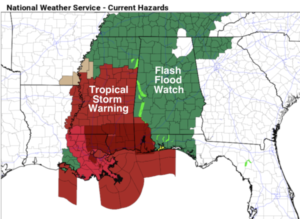
EYES STILL ON IDA: Ida is now a tropical storm this morning over South Mississippi; it will move to a point near Muscle Shoals early tomorrow, keeping Alabama on the wet, unsettled side of the system. Rain is widespread early this morning over West and Southwest Alabama, and that rain will slowly spread over the rest of the state later today and tonight, continuing at times tomorrow.
WIND: Winds could gust to 30/40 mph later today and tonight over West Alabama. This could bring down a few trees, but at this point we don’t expect widespread power outages or tree damage. Winds over East Alabama will gust to 20/30 mph at times.
FLOODING: A flash flood watch is in effect for most of Alabama through tomorrow, the exception of the northeast and southeast corner of the state. Rain amounts of 2-4 inches are likely over the western half of the state, with 1-3 inches for East Alabama through tomorrow night. If you live in a flood prone area pay close attention to flash flood warnings if they are issued.
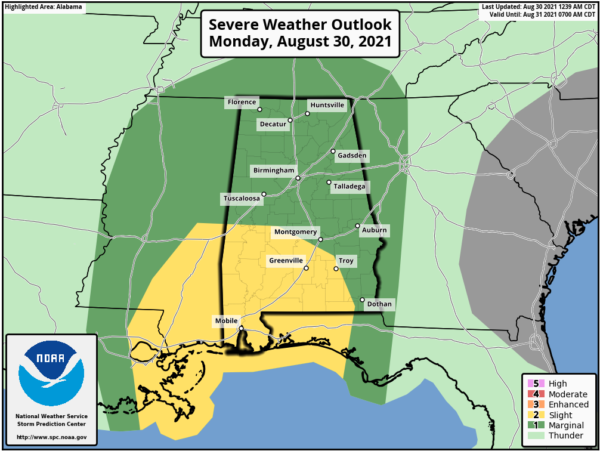
TORNADOES: A few isolated, brief tornadoes are possible over most of Alabama later today and tonight. Keep in mind the tornadoes associated with tropical systems are usually short lived, and low topped (literally under the radar). This means they can get down with little or no warning, so be very weather aware. Highest probability of a tornado or two today and tonight is over the southwest part of the state, where SPC has a “slight risk” (level 2/5) defined… there is a “marginal risk” (level 1/5) up for the rest of the state.
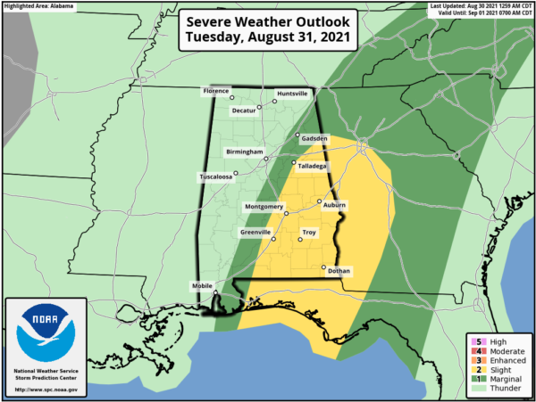
The tornado threat tomorrow will be mainly confined to East and South Alabama.
Rain will end from west to east tomorrow night and Wednesday morning as Ida moves away from the state; the sky becomes partly sunny Wednesday afternoon.
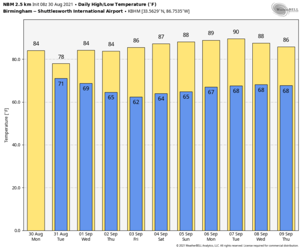
THURSDAY THROUGH THE WEEKEND: A very dry airmass will drop into Alabama Wednesday night, setting the stage for a nice stretch of rain-free weather. We expect sunny days, lower humidity, and cooler nights Thursday through Sunday. Highs will be mostly in the 80s, and lows in the 60s, but many communities across North/Central Alabama will drop into the mid to upper 50s early Thursday and Friday morning for a nice “fall feel”.
NEXT WEEK: The weather stays dry Monday and Tuesday, then moisture begins to return, and we will have some risk of scattered showers and thunderstorms over the latter half of the week. Highs will be mostly in the upper 80s… right at seasonal averages for early September. See the Weather Xtreme video for maps, graphics, and more details.
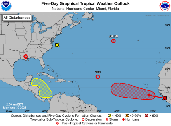
TROPICS: Tropical Depression 10 is in the middle of the Atlantic; it has a chance of becoming Tropical Storm Kate over the next day or two. It will move slowly northward and will stay far from land. A well organized tropical wave will move off the African continent today, and has a high chance of becoming a tropical storm within the next 48 hours. There are no systems threatening the Gulf Coast for the next week.
ON THIS DATE IN 1838: A major tornado, possibly the worst in Rhode Island history, passed south of Providence. It uprooted and stripped trees of their branches, unroofed or destroyed many houses, and sucked water out of ponds. The tornado barely missed a local railroad depot, where many people were waiting for a train.
BEACH FORECAST: Click here to see the AlabamaWx Beach Forecast Center page.
WEATHER BRAINS: Don’t forget you can listen to our weekly 90 minute show anytime on your favorite podcast app. This is the show all about weather featuring many familiar voices, including our meteorologists here at ABC 33/40.
CONNECT: You can find me on all of the major social networks…
Look for the next Weather Xtreme video here by 3:00 this afternoon… enjoy the day!
Category: Alabama's Weather, ALL POSTS, Weather Xtreme Videos


