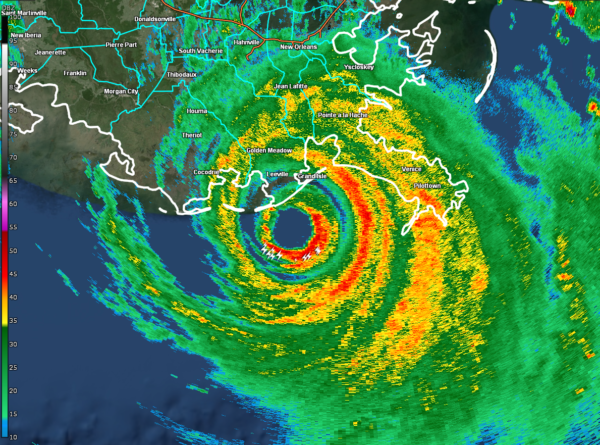
11 am Advisory — Northern Eyewall of Ida Now Moving Onshore Along Coast of Southeast Louisiana
The eyewall of Ida is now starting to move onshore just to the south-southwest of Grand Isle and just south of Leeville, very close to Port Fourchon. Here is the latest data from the NHC:
An elevated NOAA C-MAN station at Southwest Pass, Louisiana, recently reported a sustained wind of 89 mph (143 km/h) and a wind gust of 104 mph (167 km/h).
Within the past hour, sustained winds of 44 mph (70 km/h) and a gust to 60 mph (96 km/h) was reported at Lakefront Airport in New Orleans.
A NOAA National Ocean Service tide gauge in Shell Beach, Louisiana, recently reported a water level of 6.0 feet above mean higher high water, which is an approximation of inundation in that area.
A NOAA National Ocean Service tide gauge at Bay Waveland Yacht Club, Mississippi, recently reported a water level of 5.4 feet above mean higher high water, which is an approximation of inundation in that area.
SUMMARY OF 1100 AM CDT…1600 UTC…INFORMATION
———————————————–
LOCATION…28.9N 90.1W
ABOUT 25 MI…40 KM SSW OF GRAND ISLE, LOUISIANA
ABOUT 60 MI…95 KM SE OF HOUMA, LOUISIANA
MAXIMUM SUSTAINED WINDS…150 MPH…240 KM/H
PRESENT MOVEMENT…NW OR 320 DEGREES AT 13 MPH…20 KM/H
MINIMUM CENTRAL PRESSURE…933 MB…27.55 INCHES
Category: ALL POSTS, Severe Weather, Tropical


