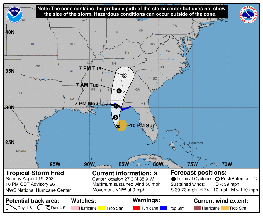
10 PM Advisory — Fred is a Little Stronger & is Less Than 24-Hours Away from Landfall
SUMMARY OF 10 PM CDT INFORMATION
LOCATION…27.3N 85.9W
ABOUT 200 MI…325 KM S OF PANAMA CITY FLORIDA
ABOUT 175 MI…280 KM SSW OF APALACHICOLA FLORIDA
MAXIMUM SUSTAINED WINDS…50 MPH…85 KM/H
PRESENT MOVEMENT…NNW OR 330 DEGREES AT 9 MPH…15 KM/H
MINIMUM CENTRAL PRESSURE…999 MB…29.50 INCHES
WATCHES AND WARNINGS
A Storm Surge Warning is in effect for…
* Coast of Florida from Indian Pass to Yankeetown
A Tropical Storm Warning is in effect for…
* Coast of the Florida Panhandle from Navarre to the Wakulla/Jefferson County line
The Tropical Storm Watch from the Alabama/Florida border to Navarre has been discontinued.
FORECAST DISCUSSION
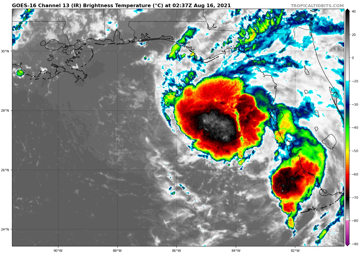
Fred remains a sheared tropical cyclone, however the overall organization of the system has improved somewhat since this afternoon. The low-level center is embedded near the western edge of the primary convective mass, and there has been an overall increase in deep convection near and to the east of the center. An Air Force Reserve reconnaissance aircraft that has been investigating Fred this evening has reported that the pressure has fallen to 999 mb, and it has found winds to support an initial intensity of 45 kt. The plane found a very small area of slightly stronger flight-level and SFMR winds well east of the center, but those winds appear to have been associated with a strong convective cell and are likely not representative of the system’s overall intensity.
Fred is moving north-northwestward or 330/08 kt, and this motion should continue overnight. The dynamical model guidance indicates that the tropical cyclone will turn northward on Monday as it approaches the coast of the Florida panhandle. A north-northeastward motion around the western periphery of a subtropical ridge over the western Atlantic should commence by the time the system makes landfall, and this general heading should continue until the system dissipates in a couple of days. The dynamical models’ envelope did not change much, and the latest consensus aids were essentially along the previous NHC track. As a result, little alteration was made to the previous official track forecast.
The cyclone is located within an area of moderate southwesterly vertical wind shear. However, most of the intensity guidance continues to suggest that Fred will strengthen a little over the next 12-18 hours. As the system nears the northern Gulf coast, the SHIPS guidance forecasts some increase in shear, and the intensity models reflect this by showing a leveling off of Fred’s intensity at that time. After landfall, Fred should weaken quickly and dissipate over the Tennessee Valley in a little more than 48 hours. The updated NHC intensity forecast is in good agreement within the HCCA and IVCN consensus aids.
Users are reminded not to focus on the exact forecast track of Fred, since rainfall, storm surge, and wind hazards will extend over an area well east of the center.
KEY MESSAGES
1. Through Tuesday, heavy rainfall may lead to flash, urban, small stream, and isolated river flooding impacts across the Southeast, including portions of southern Florida, the Big Bend and Panhandle of Florida, southeast Alabama, portions of Georgia, and the western Carolinas. By the middle of the week as Fred lifts north and inland toward the Tennessee Valley, heavy rainfall and flooding may impact the southern and central Appalachians, and the Piedmont of the Southeast and Mid-Atlantic.
2. Dangerous storm surge inundation is possible along portions of the coast of the Florida Panhandle and the Florida Big Bend region, and a Storm Surge Warning is in effect for this area. Interests in these areas should follow any advice given by local officials.
3. Tropical storm conditions are expected in the Tropical Storm Warning area in the Florida Panhandle beginning on Monday.
Category: Alabama's Weather, ALL POSTS, Severe Weather, Tropical
About the Author (Author Profile)
Scott Martin is an operational meteorologist, professional graphic artist, musician, husband, and father. Not only is Scott a member of the National Weather Association, but he is also the Central Alabama Chapter of the NWA president. Scott is also the co-founder of Racecast Weather, which provides forecasts for many racing series across the USA. He also supplies forecasts for the BassMaster Elite Series events including the BassMaster Classic.Subscribe
If you enjoyed this article, subscribe to receive more just like it.


