A Late Night Look at the Remnants of Fred and Coastal Impacts
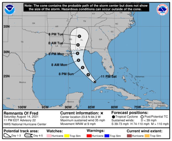
Convection is increasing with the remnants of Fred over the southeastern Gulf of Mexico. Banding is becoming evident, but the system does not have a definitive circulation yet. That is still expected to happen gradually later tonight and Sunday.
The system is expected to start moving northwestward soon. It is forecast to become a tropical cyclone again and reach tropical storm strength before reaching the coastline of the North Central Gulf on Monday night. That landfall should come Monday night, most likely on the Alabama coast, but for sure somewhere between New Orleans and Fort Walton.
Alabama’s weather, and the weather of the coast to our south, is highly dependent on the fate and track of what used to be Tropical Storm Fred.
Showers and storms will be likely along the beautiful beaches of Alabama and Northwest Florida starting Sunday. By afternoon, they will actually be associated with the first of the outer bands of what should be Tropical Storm Fred. Expect a couple of feeder bands tonight and early Monday before the main activity arrives around noon Monday. A breezy easterly wind will kick in Sunday night, averaging 15 mph.
By Monday, that wind will be picking out, averaging 20 mph and beginning to gust to 35 mph at times. Those winds will continue picking up through the afternoon, averaging 35 mph with gusts to 50 mph. Surf will increase to 4 feet Sunday night, 6 feet Monday, and 7 feet before the storm’s center arrives Monday night. The rip current risk will become high starting Sunday night and continuing through Tuesday night. There will be a threat of waterspouts and tornadoes starting late Sunday night and continuing into Monday.
OF COURSE: All of this is based on the forecast that brings Fred back to tropical storm strength. If that doesn’t happen, the forecast will be different. The eventual track will determine where the worst impacts will be, but they will be felt across a wide area of the Gulf Coast.
Category: Alabama's Weather, ALL POSTS, Tropical


