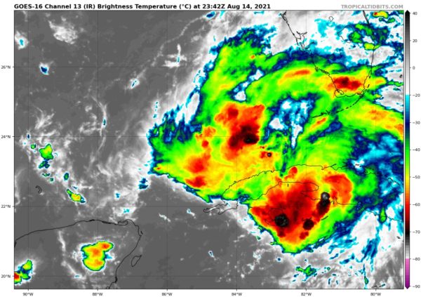
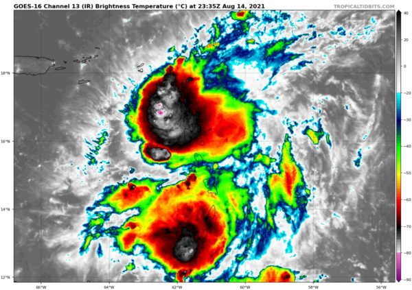
The Latest of Fred and Grace at 7 p.m.
It sounds like a 90s sitcom, but it is the latest situation report on our two current tropical entities.
Fred is of more interest to us here in Alabama now. The system is now in the southeastern Gulf of Mexico. It supposedly has developed a center again, but is not organized enough to be called a tropical depression again yet. That is expected to happen overnight and conditions favor it strengthening into a tropical storm again as it moves northwest then north toward the northern Gulf Coast. It is expected to move ashore on Monday night near Mobile, or somewhere between New Orleans and Fort Walton. The forecast intensity at landfall is 50 mph. It would bring wind, rain, riptides, and tornadoes to coastal sections, and to South and Central Alabama, a lesser version of the wind, rain, and tornadoes.
Grace is moving into the eastern Caribbean tonight. The center passed near the island of Montserrat a short time ago. Top winds are 40 mph. It could strengthen come before it crosses the Domnican Republic and Haiti on Monday. Its eventual course brings it into the Central Gulf as well. How strong ti will be by then remains to be seen.
Here is the latest advisory on Grace. The next advisor on Fred will be at 10 p.m. CDT.
BULLETIN
Tropical Storm Grace Intermediate Advisory Number 6A
NWS National Hurricane Center Miami FL AL072021
800 PM AST Sat Aug 14 2021
…POORLY ORGANIZED GRACE NOW NEAR GUADELOUPE…
…SQUALLY WEATHER MOVING ACROSS THE LESSER ANTILLES…
SUMMARY OF 800 PM AST…0000 UTC…INFORMATION
———————————————-
LOCATION…16.6N 61.5W
ABOUT 15 MI…25 KM N OF GUADELOUPE
MAXIMUM SUSTAINED WINDS…40 MPH…65 KM/H
PRESENT MOVEMENT…W OR 275 DEGREES AT 23 MPH…37 KM/H
MINIMUM CENTRAL PRESSURE…1010 MB…29.83 INCHES
WATCHES AND WARNINGS
——————–
CHANGES WITH THIS ADVISORY:
The government of the Dominican Republic has issued a Tropical Storm
Warning from Cabo Caucedo northward to Samana.
The government of the Dominican Republic has issued a Tropical Storm
Watch from the south coast of the Dominican Republic from Haiti
border eastward to Cabo Caucedo and for the north coast of the
Dominican Republic from Samana westward to the Haiti border.
SUMMARY OF WATCHES AND WARNINGS IN EFFECT:
A Tropical Storm Warning is in effect for…
* Antigua and Barbuda, Anguilla, St. Kitts and Nevis, and Montserrat
* Saba and Sint Eustatius
* Sint Maarten
* St. Martin and St. Barthelemy
* British Virgin Islands
* U.S. Virgin Islands
* Puerto Rico, including Vieques and Culebra
* Dominican Republic from Cabo Caucedo to Samana
A Tropical Storm Watch is in effect for…
* South coast of the Dominican Republic from the Haitian border to
Cabo Caucedo
* North coast of the Dominican Republic from the Haitian border to
Samana
A Tropical Storm Warning means that tropical storm conditions are
expected somewhere within the warning area.
A Tropical Storm Watch means that tropical storm conditions are
possible within the watch area, generally within 48 hours.
Interests elsewhere in the Dominican Republic, Haiti, the Turks and
Caicos Islands, the southeastern Bahamas, and Cuba should monitor
the progress of Grace. Additional watches and warnings could be
required for this area tonight or on Sunday.
For storm information specific to your area in the United
States, including possible inland watches and warnings, please
monitor products issued by your local National Weather Service
forecast office. For storm information specific to your area
outside of the United States, please monitor products issued by
your national meteorological service.
DISCUSSION AND OUTLOOK
———————-
At 800 PM AST (0000 UTC), the poorly-defined center of Tropical
Storm Grace was relocated to near latitude 16.6 North, longitude
61.5 West. Grace is moving quickly toward the west near 23 mph (37
km/h). A motion toward the west-northwest with a gradual decrease
in forward speed is expected during the next several days. On the
forecast track, the center of Grace is expected to pass through
the Leeward Islands tonight, near the Virgin Islands and Puerto Rico
on Sunday, near or over the Dominican Republic Sunday night and
Monday, and then near or over Haiti Monday night.
Maximum sustained winds are near 40 mph (65 km/h) with higher
gusts. Some strengthening is forecast during the next day or two.
Grace is likely to weaken while it moves near and across the Greater
Antilles Monday and Tuesday.
Tropical-storm-force winds extend outward up to 35 miles (55 km) to
the north of the center.
The estimated minimum central pressure is 1010 mb (29.83 inches).
HAZARDS AFFECTING LAND
———————-
Key messages for Grace can be found in the Tropical Cyclone
Discussion under AWIPS header MIATCDAT2 and WMO header WTNT42 KNHC
and on the web at
www.hurricanes.gov/graphics_at2.shtml?key_messages.
WIND: Tropical storm conditions are expected within the warning
area in the Leeward Islands tonight, and in the Virgin Islands and
Puerto Rico on Sunday, and in the Dominican Republic Sunday night.
Tropical storm conditions are possible within the watch area in the
Dominican Republic Sunday night and Monday.
RAINFALL: Grace is expected to produce the following rainfall
amounts Saturday into Tuesday:
Over the northern Leeward Islands and Virgin Islands…3 to 6
inches. This rainfall may produce scattered areas of flash and urban
flooding.
Over Puerto Rico…3 to 6 inches with isolated maximum totals of 8
inches. Heavy rainfall could lead to flash, urban and small stream
flooding and possible mudslides.
Over Haiti and the Dominican Republic…4 to 7 inches with
isolated maximum totals of 10 inches. Heavy rainfall could lead to
flash and urban flooding and possible mudslides from Monday into
Tuesday.
By mid to late next week heavy rainfall from this system could
impact portions of Cuba, the Bahamas and Florida.
NEXT ADVISORY
————-
Next complete advisory at 1100 PM AST.
$$
Forecaster Papin/Brown
Category: Alabama's Weather, ALL POSTS, Tropical


