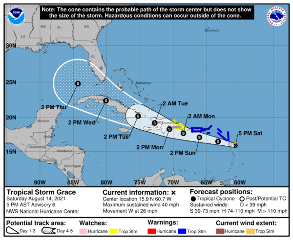
4 pm Advisory – Grace Causing Squally Weather Across the Lesser Antilles
SUMMARY OF 4 PM CDT INFORMATION
LOCATION…15.9N 60.7W
ABOUT 55 MI…85 KM ESE OF GUADELOUPE
MAXIMUM SUSTAINED WINDS…40 MPH…65 KM/H
PRESENT MOVEMENT…W OR 275 DEGREES AT 26 MPH…43 KM/H
MINIMUM CENTRAL PRESSURE…1010 MB…29.83 INCHES
WATCHES AND WARNINGS
A Tropical Storm Warning is in effect for…
* Antigua and Barbuda, Anguilla, St. Kitts and Nevis, and Montserrat
* Saba and Sint Eustatius
* Sint Maarten
* St. Martin and St. Barthelemy
* British Virgin Islands
* U.S. Virgin Islands
* Puerto Rico, including Vieques and Culebra
A Tropical Storm Watch is in effect for…
* South coast of the Dominican Republic from Punta Caucedo to Cabo Engano
* North coast of the Dominican Republic from Cabo Frances Viejo to Cabo Engano
FORECAST DISCUSSION
Grace is a poorly organized tropical storm this afternoon. The NOAA Hurricane Hunters were unable to close off a circulation, at least at their flight level of 5000 feet, but dropsonde observations and reports from some of the islands in the Lesser Antilles suggest that there’s at least a broad cyclonic circulation at the surface. The various data also indicate that the center has sped up, or re-formed, and is located farther southwest than previously estimated. Based on the aircraft data and earlier ASCAT data, the initial intensity is set at 35 kt.
Both the future track and intensity of Grace have a high level of uncertainty. For the track, the forecast is likely to be complicated by the fact that the system doesn’t currently have a tight low-level circulation, and the center could always re-form at any time, especially with convection ongoing farther to the north. In addition, the storm has not yet slowed down, and in fact, the initial motion is estimated to be toward the west (275 degrees) at 23 kt. The guidance envelope has made a notable southward shift due to the adjustment of the initial position, and the models insist that Grace will primarily have a west-northwestward heading for much of the forecast period with the speed gradually decreasing during the next 48 hours or so. The NHC track forecast has been shifted southward accordingly, although any re-formations of the center could cause this track to shift again in future advisory cycles.
If Grace slows down as forecast–which is obviously not a sure thing–environmental conditions should be conducive to allow for some strengthening before the system reaches the Greater Antilles. The southward adjustment in the official forecast now takes Grace over the Greater Antilles for a longer period of time, and the official intensity forecast is therefore lowered beyond 48 hours. This is a middle-of-the-road solution, and actually lower than most of the intensity guidance. If the forecast track shifts north or south, the system could strengthen further over water. Alternatively, Grace could go the way of Fred and dissipate before the end of the 5-day period.
In the end, the exact track of the center and the intensity of the system will likely not be as important as the heavy rainfall that is forecast to fall across the Leeward Islands and the Greater Antilles during the next few days.
KEY MESSAGES
1. Tropical storm conditions are expected in portions of the Leeward Islands tonight, and the Virgin Islands and Puerto Rico on Sunday. Tropical storm conditions are possible over eastern parts of the Dominican Republic Sunday night and Monday.
2. Heavy rainfall could lead to flash and urban flooding over the Leeward and Virgin Islands. Across Puerto Rico, the Dominican Republic, and Haiti, heavy rainfall may lead to flash, urban and small stream flooding, along with the potential for mudslides.
3. There is a risk of wind and rainfall impacts across the rest of the Dominican Republic, Haiti, the Turks and Caicos Islands, the Bahamas, Cuba, and Florida next week, but forecast uncertainty remains higher than usual. Interests in those areas should monitor the progress of Grace and updates to the forecast.


