Already Getting Hot Out There at Midday; Fred & Grace Keeps The Tropics Busy
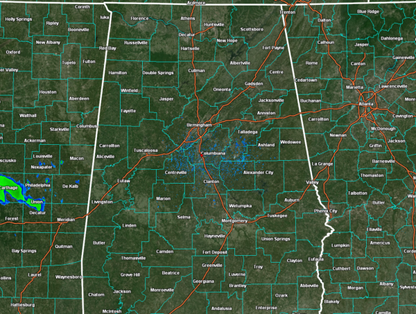
THIS WEEKEND: Today looks to be your typical late summer day in Central Alabama as we’ll have partly sunny skies with scattered showers and storms possible during the afternoon and evening hours. As of 10:50 am, there is a clean sweep on radar and temperatures were already well up in the 80s. All of the area will have a decent chance for scattered showers and storms, but the highest coverage will take place over the northern half of the area. Afternoon highs will be in the upper 80s to the mid 90s. A few lingering showers can be expected as we move into the late night hours, but all of the activity should dissipate well before midnight. We’ll be left with partly to mostly clear skies, except for some patchy dense fog in some locations. Lows will be in the lower to mid 70s.
Sunday looks to be much of the same, but rain chances look to be a little higher. Scattered to numerous showers and storms for the area, with the higher coverage of storms over the northern half. Highs in the upper 80s to the lower 90s.
NEXT WEEK: On Monday, we’ll have a cold front moving into the northern half of the area and Fred will begin to move onshore with tropical moisture moving up into the southern parts of the area. For much of Central Alabama, we’ll have the potential for scattered to numerous showers and storms with slightly cooler temperatures. Highs in the lower to mid 80s for most.
Tuesday shows the front moves back to the north out of the area as a warm front and the center of Fred moves into Central Alabama. While the GFS is not giving Fred much to look at, the European shows a much better organized Fred bringing gusty winds, heavy rain, and the potential for a brief spin-up tornado or two. For now, wind gusts only look to reach 35-40 mph, mainly for locations close to and just east of the center of Fred. Locations southwest of the center may see rain end quickly for the most part. Highs will be in the mid to upper 80s.
While Fred will be out of the area on Wednesday, he will leave very moist air in his wake. We’ll return to scattered to numerous showers and storms becoming likely by the afternoon hours, with highs in the mid 80s to the lower 90s. Not much change for Thursday and Friday… scattered to numerous showers and storms become likely by the afternoon. Highs in the mid 80s to the lower 90s.
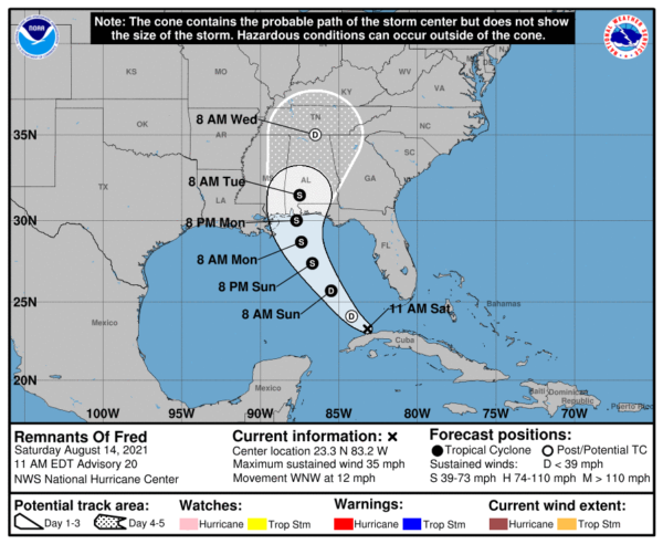
FRED DEGENERATES INTO AN OPEN WAVE: At 10:00 AM CDT, Fred had degenerated into an open wave and was located around 50 miles west of Havana, Cuba. The remnants are moving toward the west-northwest near 12 mph, and this motion is expected to continue today. A turn toward the northwest is expected by tonight, followed by a northward motion by Sunday night.
On the forecast track, Fred or its remnants are expected to pass west of the lower Florida Keys this afternoon, move across the eastern Gulf of Mexico tonight through Monday, and move inland over the northern Gulf coast Monday night.
Maximum sustained winds are near 35 mph (55 km/h) with higher gusts. Fred is expected to re-develop into a tropical depression on Sunday, with gradual strengthening to a tropical storm expected after the system re-develops. The estimated minimum central pressure is 1013 mb (29.92 inches).
Interests in the northern coast of the Gulf of Mexico from Mississippi to the central Florida Panhandle should monitor the progress of the remnants of Fred. Watches could be required for portions of this area later in the weekend.
Today through Monday, heavy rainfall could lead to areal, urban, and small stream flooding impacts, and cause new and renewed river flooding, across southern Florida, the Big Bend, and Panhandle. From Monday onward, heavy rain and flood impacts could extend into other portions of the Southeast and into the southern and central Appalachians and Piedmont as Fred interacts with a front in the area.
Fred is forecast to regenerate as a tropical cyclone over the Gulf of Mexico on Sunday, and bring a risk of tropical storm conditions to portions of the northern Gulf coast, especially from coastal Mississippi to the Florida Panhandle beginning on Monday. Watches may be required for a portion of this area later in the weekend.
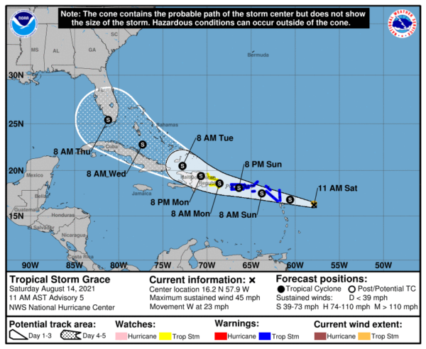
TROPICAL STORM GRACE STRENGTHENS: At 10:00 AM CDT, the center of Tropical Storm Grace was located around 265 miles to the east-southeast of the Leeward Island, and was moving toward the west near 23 mph. A motion toward the west-northwest with a gradual decrease in forward speed is expected during the next several days.
On the forecast track, the center of Grace is expected to move over the Leeward Islands tonight, over the Virgin Islands and Puerto Rico on Sunday, over the Dominican Republic on Monday, and then between the southeastern Bahamas and Cuba on Tuesday.
Maximum sustained winds are near 45 mph, with higher gusts. Some strengthening is forecast during the next day or so. Grace is likely to weaken while it moves near and across the Greater Antilles Sunday night through Monday night. The estimated minimum central pressure is 1005 mb (29.68 inches).
Tropical storm conditions are expected in portions of the Leeward Islands tonight and early Sunday, and the Virgin Islands and Puerto Rico on Sunday. Tropical storm conditions are possible over eastern parts of the Dominican Republic by early Monday.
Heavy rainfall could lead to flash and urban flooding over the Leeward and Virgin Islands. Across Puerto Rico and the Dominican Republic, heavy rainfall may lead to flash, urban and small stream flooding, along with the potential for mudslides.
There is a risk of wind and rainfall impacts across the rest of the Dominican Republic, Haiti, the Turks and Caicos Islands, the Bahamas, and Florida next week, and interests in those areas should monitor the progress of Grace and updates to the forecast.
Category: Alabama's Weather, ALL POSTS, Tropical


