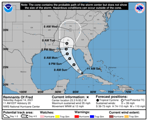
10 am Advisory — Fred Temporarily Degenerates Into an Open Wave; Expected to Reorganize
SUMMARY OF 1000 AM CDT INFORMATION
LOCATION…23.3N 83.2W
ABOUT 50 MI…80 KM W OF HAVANA, CUBA
ABOUT 125 MI…205 KM SW OF KEY WEST, FLORIDA
MAXIMUM SUSTAINED WINDS…35 MPH…55 KM/H
PRESENT MOVEMENT…WNW OR 300 DEGREES AT 12 MPH…19 KM/H
MINIMUM CENTRAL PRESSURE…1013 MB…29.92 INCHES
WATCHES AND WARNINGS
There are no coastal watches or warnings in effect. Interests in the northern coast of the Gulf of Mexico from Mississippi to the central Florida Panhandle should monitor the progress of the remnants of Fred. Watches could be required for portions of this area later in the weekend.
FORECAST DISCUSSION
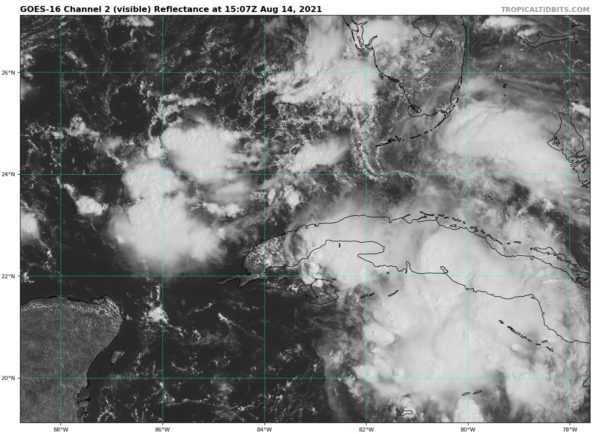
A combination of shear caused by an upper-level trough over the Gulf of Mexico and land interaction has caused Fred to degenerate into an open wave. Surface observations from Cuba do not show a closed circulation, and satellite imagery shows at least two vorticity centers embedded in a large trough. The strongest convection is currently near and southeast of a vorticity center near the Isle of Youth. The initial position is a mean position between the vorticity center, and the initial intensity of 30 kt is based on Air Force Reserve Hurricane Hunter aircraft data to the northeast of the estimated center position.
The global models forecast the upper-level trough to move northward and weaken during the next 24 h and indicate that Fred will re-form a closed circulation over the eastern Gulf of Mexico Sunday morning. Given the strength of the upper-level trough, that forecast may well be too bullish. However, given the agreement in the guidance, the revised intensity forecast will call for Fred to regain tropical cyclone status at about the 24 h point, followed by gradual strengthening in a less than ideal upper-level wind environment until landfall along the northern Gulf coast. After landfall, the system should weaken and dissipate between 96-120 h.
The initial motion is a very uncertain 300/10. The system is expected to move west-northwestward to northwestward around the western periphery of the subtropical ridge, with a turn toward the north as the system nears the northern Gulf coast in 60-72 h. While the forecast guidance is in good agreement on this general scenario, there is uncertainty as to where the center of Fred will be when it re-forms. Therefore, users should not concentrate on the details of the forecast track, which could change quite a bit during the next 24-36 h.
Although all coastal watches and warnings are discontinued at this time, the National Hurricane Center will continue 6-hourly advisories on the remnants of Fred in anticipation of re-development and the potential need for watches and warnings on the northern Gulf coast later in the weekend.
KEY MESSAGES
1. Today through Monday, heavy rainfall could lead to areal, urban, and small stream flooding impacts, and cause new and renewed river flooding, across southern Florida, the Big Bend, and Panhandle. From Monday onward, heavy rain and flood impacts could extend into other portions of the Southeast and into the southern and central Appalachians and Piedmont as Fred interacts with a front in the area.
2. Fred is forecast to regenerate as a tropical cyclone over the Gulf of Mexico on Sunday, and bring a risk of tropical storm conditions to portions of the northern Gulf coast, especially from coastal Mississippi to the Florida Panhandle beginning on Monday. Watches may be required for a portion of this area later in the weekend.
Category: Alabama's Weather, ALL POSTS, Tropical


