Sun, Heat, Storms, And A Tropical Storm
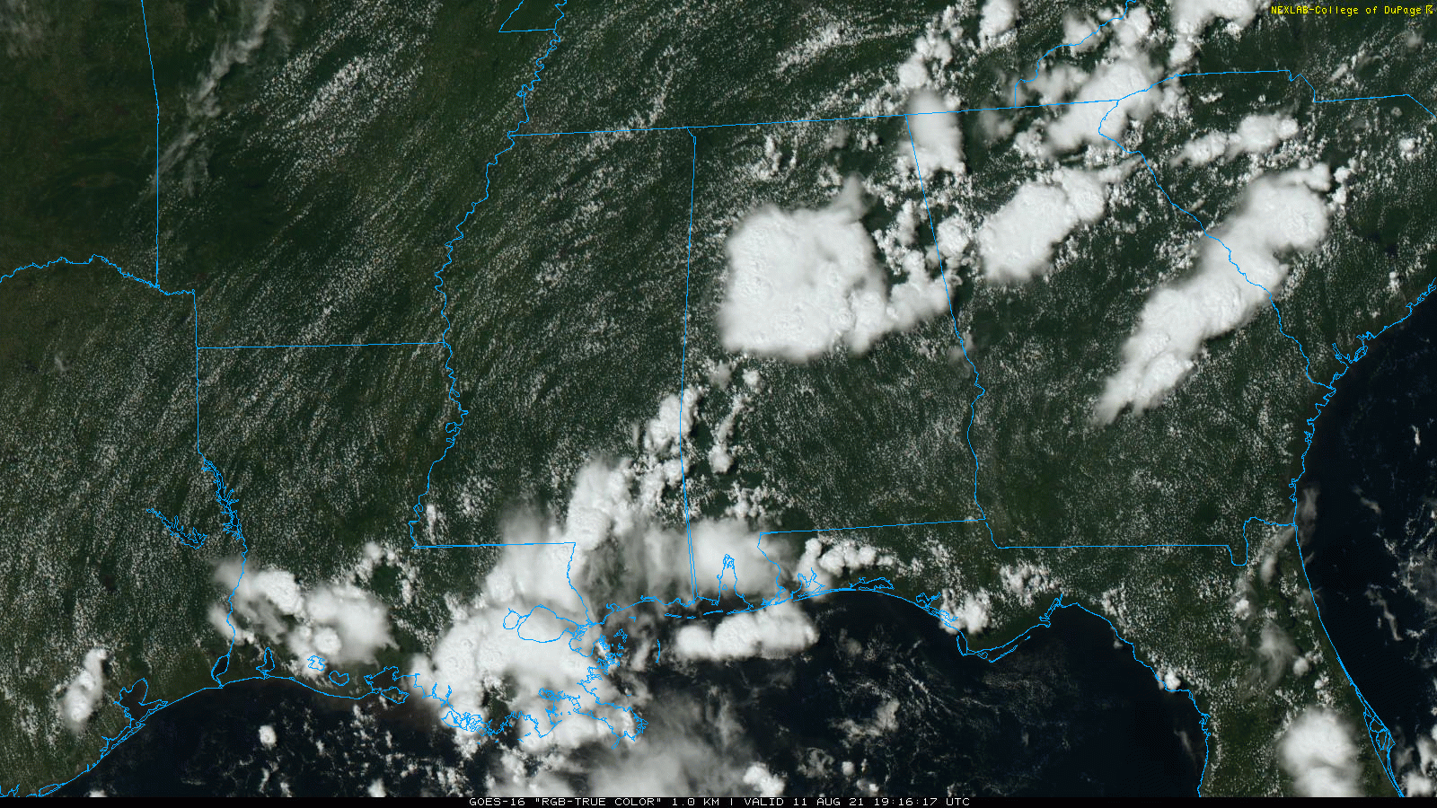
RADAR CHECK: A number of showers and thunderstorms, some with very heavy rain and lots of lightning, are in progress across Alabama this afternoon. But, like most summer days, the sun is out in many areas with temperatures in the low 90s away from the storms. Storms will end after sunset tonight.
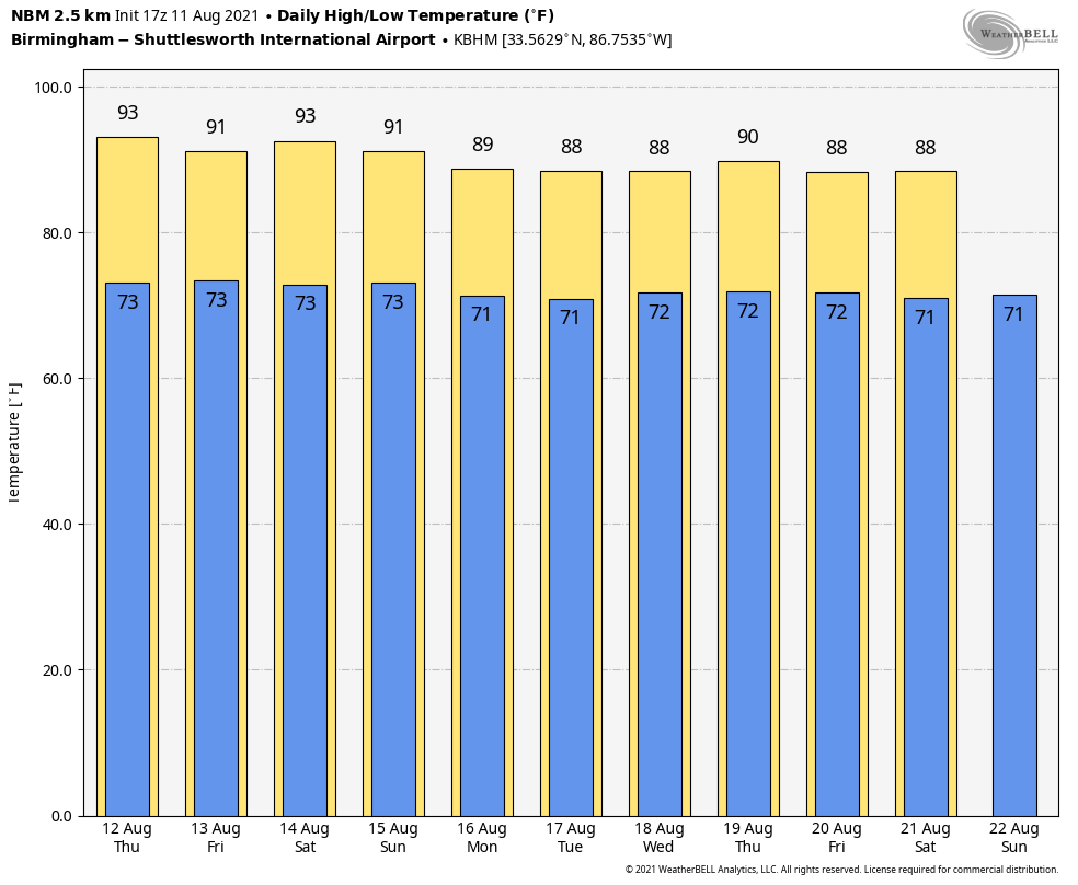
TOMORROW THROUGH THE WEEKEND: We don’t expect much change tomorrow, Friday and Saturday. A mix of sun and clouds daily with scattered showers and thunderstorms, most active between 12:00 noon and 10:00 p.m. Highs will be in the low 90s tomorrow, and close to 90 Friday and Saturday. There could be an increase in the number of showers and storms Sunday across the southeast part of the state, elsewhere showers and storms will remain scattered with some sun at times. The high Sunday will be in the upper 80s.
NEXT WEEK: A broad tropical low will move into East Alabama or Georgia early in the week, and has potential to bring deeper moisture and higher rain coverage Monday and Tuesday. Then, Wednesday through Friday should feature partly sunny days with the usual round of “scattered, mostly afternoon and evening showers and storms” each day. Highs during the week will be mostly in the mid to upper 80s, which is below average for mid-August in Alabama. See the Weather Xtreme video for maps, graphics, and more details.
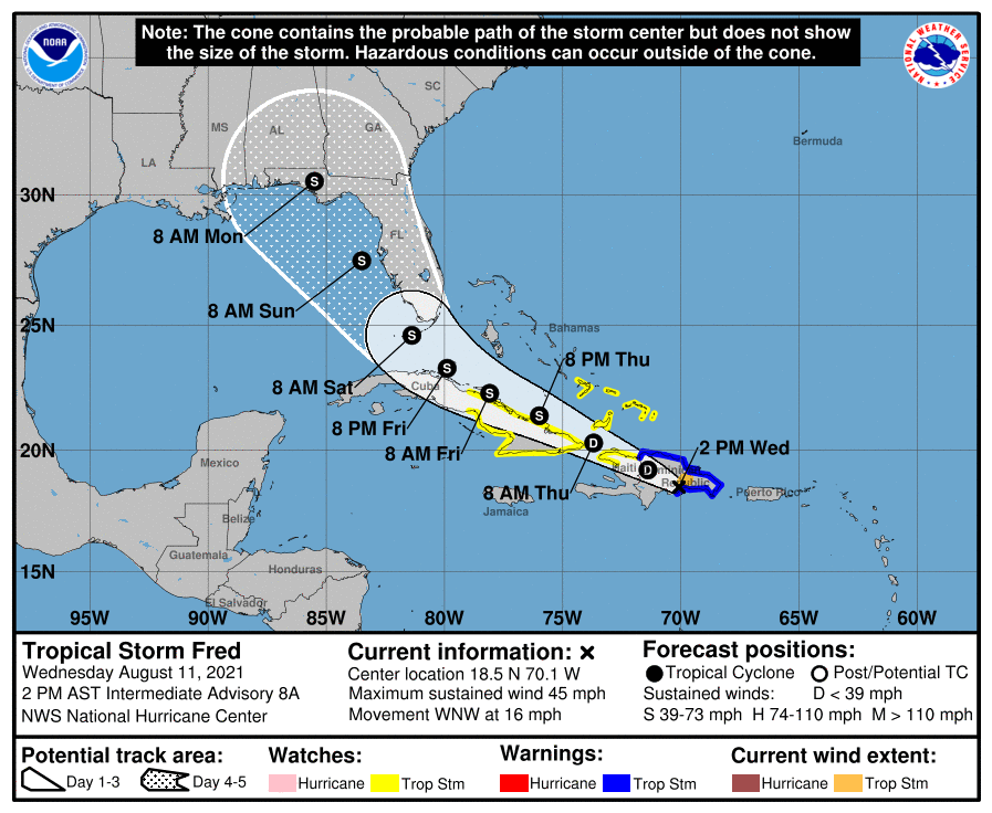
FOLLOWING FRED: Fred is over the mountainous island of Hispaniola this afternoon, and looks disorganized on satellite images. It will likely be downgraded to a tropical depression soon by NHC. If the system survives, the NHC track has it near Key West Saturday morning, and on the Florida coast near Mexico Beach early Monday morning.
Important notes…
*NHC keeps the system under hurricane strength in their forecast, and there is no model that shows a hurricane at the time of landfall in Florida. Despite warm sea surface temperatures, dry air and shear is expected to limit any intensification in the Gulf of Mexico. This could easily be a weak tropical storm, or even an open wave when it moves inland.
*The main impact (wind, rain, storm surge, isolated tornadoes) will be along and east of the circulation center. For the moment it looks like the Alabama Gulf Coast and the western Florida Panhandle (places like Gulf Shores, Pensacola, and Navarre Beach) will be on the good, west side of the system.
*Remember, the average NHC track error in a 5 day forecast is 200 miles, so please know the forecast (both track and intensity) can, and probably will change over the next few days.
*If you have a trip planned to the Gulf Coast Sunday or early next week, I would still wait to make any change in plans. Wait until Friday if possible, then is when clarity in the impact will be much better. Even then I won’t be able to make specific recommendations since different people go to the beach for different reasons.
*Even if Fred is a weak tropical storm, it will bring higher rain chances and the threat of dangerous rip currents to the coast of the Florida Panhandle Sunday and Monday.
GRACE? A well organized tropical wave located over the eastern tropical Atlantic several hundred miles west-southwest of the Cabo Verde Islands continues to produce disorganized showers and thunderstorms. Environmental conditions are expected to become gradually more conducive for development of this system, and a tropical depression could form by early next week while moving generally westward across the tropical Atlantic near 20 mph. This system could reach portions of the Leeward Islands by late Saturday. If it becomes a tropical storm, the name will be Grace.
ON THIS DATE IN 1999: An F2 tornado touched down in the metropolitan area of Salt Lake City. The tornado lasted ten minutes and killed one person, injured more than 80 people, and caused more than $170 million in damages. It was the most destructive tornado in Utah’s history and awakened the entire state’s population to the fact that the Beehive State does experience tornadoes.
BEACH FORECAST: Click here to see the AlabamaWx Beach Forecast Center page.
WEATHER BRAINS: Don’t forget you can listen to our weekly 90 minute show anytime on your favorite podcast app. This is the show all about weather featuring many familiar voices, including our meteorologists here at ABC 33/40.
CONNECT: You can find me on all of the major social networks…
Look for the next Weather Xtreme video here by 6:00 a.m. tomorrow…
Category: Alabama's Weather, ALL POSTS, Weather Xtreme Videos
About the Author (Author Profile)
James Spann is one of the most recognized and trusted television meteorologists in the industry. He holds the AMS CCM designation and television seals from the AMS and NWA. He is a past winner of the Broadcast Meteorologist of the Year from both professional organizations.Subscribe
If you enjoyed this article, subscribe to receive more just like it.


