Warm with a Few Showers Out There So Far This Afternoon
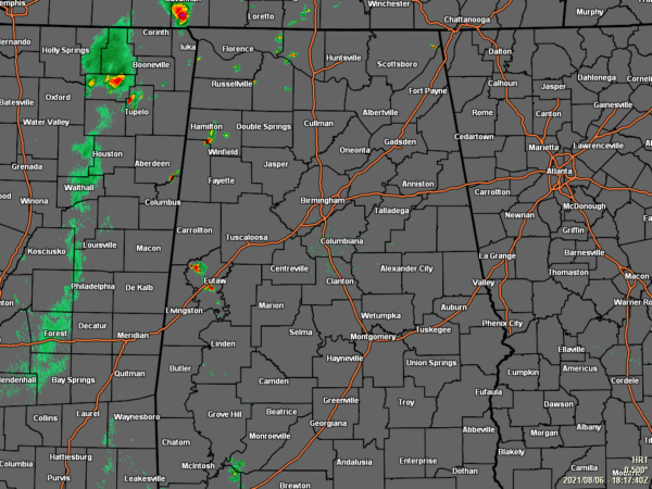
As of 1:17 pm, a few showers and storms have formed over the western portions of Central Alabama, especially over portions of Greene County and Marion County. At this point, nearly all of the rest of Central Alabama is dry. Temperatures as of the 1 pm roundup were in the 80s across the area. Birmingham was at 84 degrees. The warm spot was Troy at 88 degrees. The cool spots was Haleyville at 81 degrees.
For the rest of today, skies will be partly to mostly cloudy, with a chance of isolated to scattered afternoon showers and thunderstorms across Central Alabama. Overall rain chances are around 20-30% from east to west. Afternoon highs will be in the mid-80s to the lower 90s across the area from northwest to southeast. Same story for tonight and through the overnight hours, as a few isolated to scattered showers will be possible through the evening, with nearly all of the activity dissipating by the late-night hours. Lows will be in the mid-60s to the lower 70s.
Saturday will be a mixed bag of weather across Central Alabama as it will be dry in the western parts of the area with rain chances increasing as you move eastward. The higher rain chances will be east of the I-65 corridor, with the most activity along the AL/GA state line. Highs will be in the upper 80s to the lower 90s.
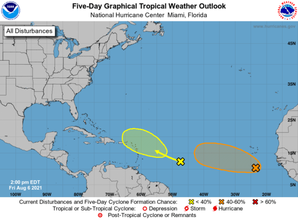
THE TROPICS: A large area of disorganized cloudiness and showers located a few hundred miles south of the Cabo Verde Islands (orange X) is associated with a tropical wave and an associated broad area of low pressure. Environmental conditions appear somewhat conducive for gradual development over the next several days, and a tropical depression could form late this weekend or early next week while the system moves generally west-northwestward across the tropical Atlantic.
* Formation chance through 48 hours…low…30 percent.
* Formation chance through 5 days…medium…60 percent.
A tropical wave located over the west-central tropical Atlantic (yellow X) is producing limited shower activity. Development, if any, of this system is expected to be slow to occur as it moves west-northwestward and approaches the Lesser Antilles early next week.
* Formation chance through 48 hours…low…near 0 percent.
* Formation chance through 5 days…low…20 percent.
Category: Alabama's Weather, ALL POSTS, Tropical


