A Few Isolated Showers Later Today; Temps Stay Below Average
ANOTHER PLEASANT MORNING: A relatively dry airmass covers North Alabama this morning, and once again some of the cooler places have dipped into the 60-65 degree range around daybreak for a little taste of fall. Look for a partly sunny sky today across the state today with a few isolated showers or storms this afternoon and this evening. The chance of any one spot getting wet is in the 10-20 percent range, and the high will be in the upper 80s.
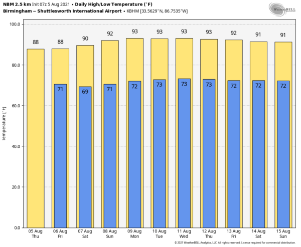
TOMORROW THROUGH THE WEEKEND: An upper trough will bring an increase in the number of showers and storms tomorrow and Saturday, but they will still be scattered in nature, and it won’t rain everywhere. Showers become fewer in number Sunday as an upper ridge begins to rebuild over the region. The high tomorrow and Saturday will be in the 86-90 degree range, followed by low 90s Sunday. The chance of rain for any given location tomorrow and Saturday is 35-45 percent, then dropping to 20 percent Sunday.
NEXT WEEK: An upper ridge will be parked over the Deep South, setting the stage for some typical August weather. Partly sunny days with just a few widely scattered showers and storms around each afternoon and evening. Highs will be mostly in the low 90s… right at seasonal averages. See the Weather Xtreme video for maps, graphics, and more details.
TROPICS: NHC is monitoring two tropical waves across the Atlantic basin. The lead wave is over the central tropical Atlantic, and is producing a broad area of disorganized showers and thunderstorms. Environmental conditions are expected to be marginally conducive for some slow development east of the Lesser Antilles by early next week while the disturbance moves west-northwestward at 10 to 15 mph. For now the chance of development with this feature is only 20 percent over the next five days.
To the east, a tropical wave just inland over Africa is producing a large area of showers and thunderstorms over the Guinea Highlands. This wave is expected to move off the west African coast later today. Environmental conditions appear somewhat conducive for gradual development, and a tropical depression could form over the eastern tropical Atlantic by early next week while the system moves westward to west-northwestward at about 15 mph. Chance of development here is up to 50 percent over the next five days.
There are no systems close to the Gulf of Mexico or the U.S. for now.
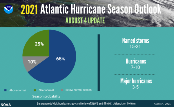
UPDATED HURRICANE SEASON OUTLOOK: The updated outlook released yesterday from NOAA reflects that the number of expected named storms (winds of 39 mph or greater) is 15-21, including 7-10 hurricanes (winds of 74 mph or greater), of which 3-5 could become major hurricanes (Category 3, 4, or 5 with winds 111 mph or greater). This updated outlook includes the 5 named storms that have formed so far.
ON THIS DATE IN 1875: Several tornadoes moved across northern and central Illinois. One of the stronger tornadoes touched down in Warren and Knox County where it destroyed 25 homes and killed two people. Another in a series of tornadoes touched down near Knoxville and moved east into northern Peoria County. This estimated F4 tornado injured 40 people and was described by eyewitnesses as looking like a “monstrous haystack.”
BEACH FORECAST: Click here to see the AlabamaWx Beach Forecast Center page.
WEATHER BRAINS: Don’t forget you can listen to our weekly 90 minute show anytime on your favorite podcast app. This is the show all about weather featuring many familiar voices, including our meteorologists here at ABC 33/40.
CONNECT: You can find me on all of the major social networks…
Look for the next Weather Xtreme video here by 3:00 this afternoon… enjoy the day!
Category: Alabama's Weather, ALL POSTS, Weather Xtreme Videos


