Elsa Now a Hurricane
Elsa is now a hurricane.
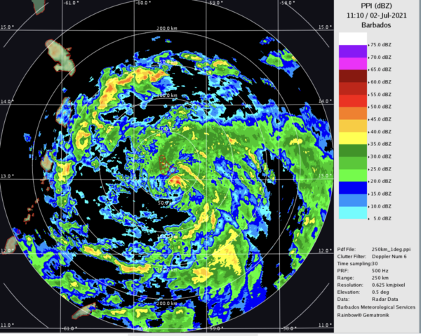
Radar imagery from Barbados indicates that an eye seems to be forming with a partially closed eyewall observed.
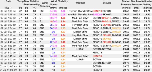
And winds have gusted to 86 mph at Barbados as the center passes just to the south. Check out these observations since 11 p.m. local last night:
In addition, the airport in Barbados has recorded wind gusts of hurricane force (86 mph wind gust). Based on all of this, I think that Elsa is likely a low end hurricane with 75 to 80 mph winds or so. This means that all interests in the Windward Islands, and in particular the island of St. Lucia and St. Vincent, should be getting ready for hurricane conditions.
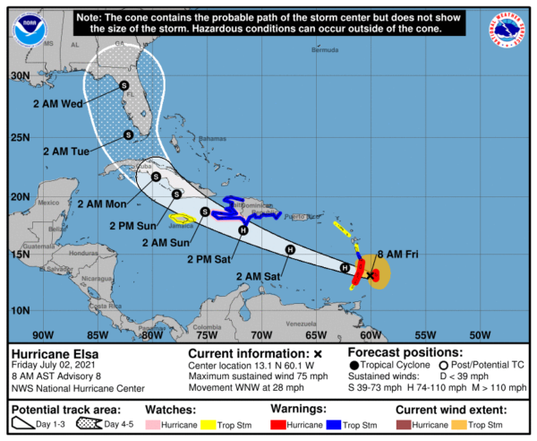
It is impossible to say exactly where Elsa will end up in relation to the Gulf Coast. Or how strong it will be. Here is the official forecast but it will change over time. Here is the official forecast:
Key Messages:
1. Hurricane conditions are occurring on Barbados and are expected
elsewhere in the Hurricane Warning area in the next few hours.
Tropical storm conditions are expected to begin later this morning
in other portions of the Windward and Leeward Islands. Tropical
storm conditions are expected and hurricane conditions are possible
over southern portions of Hispaniola on Saturday. Tropical storm
conditions are possible over Jamaica beginning Saturday night.
2. Heavy rainfall from Elsa will move quickly across the Windward
and southern Leeward Islands today, including Barbados. Outer rain
bands will impact Puerto Rico late today into Saturday, and southern
Hispaniola and Jamaica Saturday into Sunday. Flooding and mudslides
are possible.
3. There is a risk of wind and rainfall impacts in portions of
Cuba, the Turks and Caicos, and the Bahamas through early next
week. Interests in these areas should monitor Elsa’s progress and
updates to the forecast.
4. There is a risk of storm surge, wind, and rainfall impacts in the
Florida Keys and portions of the Florida Peninsula early next week.
However, the forecast uncertainty remains larger than usual due to
Elsa’s potential interaction with the Greater Antilles this weekend.
Interests in Florida should monitor Elsa’s progress and updates to
the forecast.
BULLETIN
Hurricane Elsa Special Advisory Number 8
NWS National Hurricane Center Miami FL AL052021
830 AM AST Fri Jul 02 2021
…ELSA STRENGTHENS INTO A HURRICANE…
…HURRICANE CONDITIONS SPREADING THROUGH THE WINDWARD ISLANDS..
SUMMARY OF 830 AM AST…1230 UTC…INFORMATION
———————————————-
LOCATION…13.1N 60.1W
ABOUT 40 MI…65 KM W OF BARBADOS
ABOUT 75 MI…120 KM E OF ST. VINCENT
MAXIMUM SUSTAINED WINDS…75 MPH…120 KM/H
PRESENT MOVEMENT…WNW OR 285 DEGREES AT 28 MPH…44 KM/H
MINIMUM CENTRAL PRESSURE…995 MB…29.39 INCHES
WATCHES AND WARNINGS
——————–
CHANGES WITH THIS ADVISORY:
The Meteorological Service of Barbados has issued a Hurricane
Warning for Barbados, St. Vincent, and the Grenadines.
The Meteorological Service of St. Lucia has issued a Hurricane
Warning for St. Lucia.
SUMMARY OF WATCHES AND WARNINGS IN EFFECT:
A Hurricane Warning is in effect for…
* Barbados
* St. Lucia
* St. Vincent and the Grenadines
A Tropical Storm Warning is in effect for…
* Martinique
* The southern coast of Dominican Republic from Cabo Engano to the
border with Haiti
* Entire coast of Haiti
A Hurricane Watch is in effect for…
* Southern portion of Haiti from Port Au Prince to the southern
border with the Dominican Republic
A Tropical Storm Watch is in effect for…
* Grenada and its dependencies
* Saba and Sint Eustatius
* Jamaica
* Dominica
A Hurricane Warning means that hurricane conditions are expected
somewhere within the warning area, in this case in the next few
hours. Preparations to protect life and property should be rushed
to completion.
A Tropical Storm Warning means that tropical storm conditions are
expected somewhere within the warning area.
A Hurricane Watch means that hurricane conditions are possible
within the watch area. A watch is typically issued 48 hours
before the anticipated first occurrence of tropical-storm-force
winds, conditions that make outside preparations difficult or
dangerous.
A Tropical Storm Watch means that tropical storm conditions are
possible within the watch area.
Interests elsewhere in the Windward Islands, Leeward Islands, the
Virgin Islands, Puerto Rico, the Dominican Republic, and Cuba
should monitor the progress of Elsa. Additional watches and
warnings will likely be required later today, including Hurricane
Warnings for portions of Haiti and the Dominican Republic.
For storm information specific to your area, please monitor
products issued by your national meteorological service.
DISCUSSION AND OUTLOOK
———————-
At 830 AM AST (1230 UTC), the center of Hurricane Elsa was located
near latitude 13.1 North, longitude 60.1 West. Elsa is moving toward
the west-northwest near 28 mph (44 km/h), and this motion is
expected to continue during the next couple of days. On the
forecast track, Elsa will pass near or over portions of the
Windward Islands or the southern Leeward Islands this morning, move
across the eastern Caribbean Sea late today and tonight, and move
near the southern coast of Hispaniola on Saturday. By Sunday, Elsa
is forecast to move near Jamaica and portions of eastern Cuba.
Reports from Barbados indicate that maximum sustained winds have
increased to near 75 mph (120 km/h) with higher gusts. Little
change in strength is forecast during the next 48 hours.
Hurricane-force winds extend outward up to 25 miles (35 km) from the
center and tropical-storm-force winds extend outward up to 140 miles
(220 km). Barbados recently reported sustained winds of 74 mph
(119 km/h) and a wind gust of 86 mph (138 km/h).
The estimated minimum central pressure is 995 mb (29.39 inches).
Barbados recently reported a pressure of 998 mb (29.47 inches).
HAZARDS AFFECTING LAND
———————-
Key messages for Elsa can be found in the Tropical Cyclone
Discussion under AWIPS header MIATCDAT5, WMO header WTNT45 KNHC and
on the web at
www.hurricanes.gov/graphics_at5.shtml?key_messages.
WIND: Hurricane conditions are occurring on Barbados, and are
expected in the hurricane warning area in the Windward Islands in
the next few hours. Tropical storm conditions are expected in
portions of the Windward and southern Leeward Islands within the
tropical storm warning areas and are possible in the tropical storm
watch areas later today. Tropical storm conditions are expected in
the warning areas in the Dominican Republic and Haiti on Saturday,
with hurricane conditions possible in southern Haiti. Tropical
storm conditions are possible in Jamaica Saturday night or early
Sunday.
STORM SURGE: A storm surge will raise water levels by as much as 1
to 3 feet above normal tide levels in areas of onshore winds in
the hurricane warning area in the Windward Islands and along the
southern coast of Hispaniola.
RAINFALL: Elsa is expected to produce rainfall totals of 3 to 6
inches with maximum amounts of 10 inches today across the Windward
and southern Leeward Islands, including Barbados. This rain may
lead to isolated flash flooding and mudslides.
Over Puerto Rico, rainfall of 1 to 3 inches with localized amounts
of 5 inches is expected late today into Saturday. This rain may lead
to isolated flash flooding and minor river flooding, along with the
potential for mudslides.
Across portions of southern Hispaniola and Jamaica, rainfall of 4 to
8 inches with isolated maximum amounts of 12 inches is possible
Saturday into Sunday. This rain may lead to scattered flash
flooding and mudslides.
NEXT ADVISORY
————-
Next complete advisory at 1100 AM AST.
$$
Forecaster Beven
Category: Alabama's Weather, ALL POSTS, Tropical


