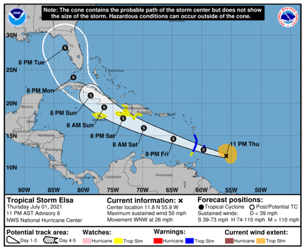
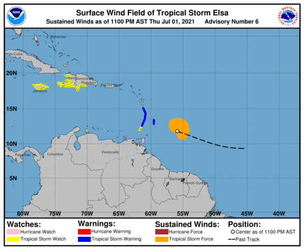
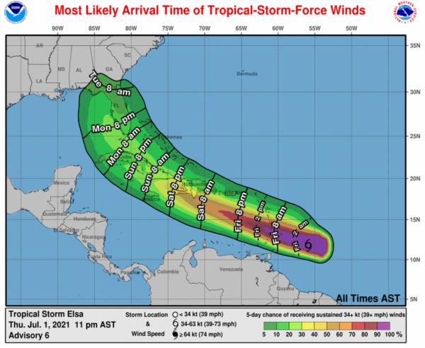
At 10 pm, Elsa Strengthening; Approaching the Lesser Antilles
SUMMARY OF 1100 PM AST…0300 UTC…INFORMATION
LOCATION…11.8N 55.9W
ABOUT 260 MI…420 KM ESE OF BARBADOS
ABOUT 370 MI…600 KM ESE OF ST. VINCENT
MAXIMUM SUSTAINED WINDS…50 MPH…85 KM/H
PRESENT MOVEMENT…WNW OR 290 DEGREES AT 26 MPH…43 KM/H
MINIMUM CENTRAL PRESSURE…1003 MB…29.62 INCHES
SUMMARY OF WATCHES AND WARNINGS IN EFFECT
A Tropical Storm Warning is in effect for…
* Barbados
* Martinique
* St. Lucia
* St. Vincent and the Grenadines
A Tropical Storm Watch is in effect for…
* Grenada and its dependencies
* The southern and western coasts of Haiti from the southern border of the Dominican Republic to Le Mole St. Nicholas
* The southern coast of the Dominican Republic from the southern border of Haiti eastward to Punta Palenque
* Jamaica
Interests elsewhere in the Windward Islands, Leeward Islands, the Virgin Islands, Puerto Rico, the Dominican Republic, Haiti, and eastern Cuba should monitor the progress of Elsa. Additional watches and warnings will likely be required on Friday.
FORECAST DISCUSSION
The convective structure with Elsa tonight appears to be somewhat better organized than earlier, with a bursting type pattern of cold -75 to -80 C cloud top temperatures just to the northeast of the estimated center. However, a SSMIS microwave pass at 2130 UTC revealed that, underneath the cirrus, the deeper convection is still struggling to rotate up-shear as the system moves quickly to the west-northwest. Despite that fact, an ASCAT-A pass clipped the northeastern edge of Elsa and showed several wind retrievals of 44-46 kt. In addition, the most recent subjective Dvorak satellite classification from TAFB was T3.0/45 kt. In support of these data, the current estimated intensity was raised to 45 kt for this advisory.
Elsa continues to move quickly to the west-northwest at 290/23 kt. A continued rapid motion to the west-northwest is expected for the next 36 hours as the storm remains steered by a strong subtropical ridge to its north, and the guidance has trended a bit faster once again tonight. Thereafter, Elsa will reach the western extent of this ridge, which will be eroded by a strong mid-latitude trough centered off the eastern US. Once again, the guidance spread increases greatly by this time, with the GFS/UKMET on the slow and left side of the guidance envelope, the ECMWF and its ensembles on the fast and right side, and the Canadian roughly in the middle. Interestingly, the latest GFS ensembles show some bifurcation within the larger guidance envelope, with the strongest members further south and west. The latest NHC track forecast is close to the previous track early on but somewhat faster, and in the latter period was nudged just slightly eastward towards the TVCN consensus. However, the track forecast in the latter time period remains low confidence.
The intensity forecast with Elsa also continues to be challenging this evening. While the GFS-based SHIPS guidance indicates that the current 200-850-hPa vertical wind shear is only 5-10 kt, the strong east-southeasterly low-level flow Elsa is embedded in is resulting in stronger 15-20 kt of west-northwesterly mid-level shear. This mid-level shear has thus far prevented deep convection from wrapping around the circulation and helping to align the low- and mid-level vortex, like the GFS/HWRF models have been forecasting over the past day. Despite this convective structure, the fast east-southeasterly low-level flow will likely continue to enhance the winds on the north side of the circulation. For this reason, the intensity forecast still shows intensification in the short term to 55 kt. However, additional intensification beyond that will likely require a better vertically aligned vortex. This structure may be difficult to achieve as moderate mid-level shear continues, counter to the motion vector of the storm. After 48 hours, the intensity forecast shows slight weakening given the possibility of land interaction over the Greater Antilles. The latest intensity forecast remains on the conservative side relative to the guidance, especially the HWRF/HMON regional hurricane models, and is also low confidence.
KEY MESSAGES
1. Tropical storm conditions are expected to begin early Friday in portions of the Windward and southern Leeward Islands, and are possible over portions of southern Hispaniola on Saturday, and are also possible over Jamaica beginning Saturday night.
2. Heavy rainfall from Elsa will move quickly across the Windward and southern Leeward Islands, including Barbados, on Friday. Outer rain bands will impact Puerto Rico on Friday and southern Hispaniola by early Saturday. Flooding and mudslides are possible.
3. There is a risk of wind and rainfall impacts in portions of Cuba, the Turks and Caicos, and the Bahamas through early next week. Interests in these areas should monitor Elsa’s progress and updates to the forecast.
4. There is a risk of storm surge, wind, and rainfall impacts in the Florida Keys and portions of the Florida Peninsula early next week. However, the forecast uncertainty remains larger than usual due to Elsa’s potential interaction with the Greater Antilles this weekend. Interests in Florida should monitor Elsa’s progress and updates to the forecast.


