What Impacts Can You Expect From PTC-3… Potentially Named Claudette by Midday Tomorrow
Collaborative post by Bill Murray and Scott Martin.
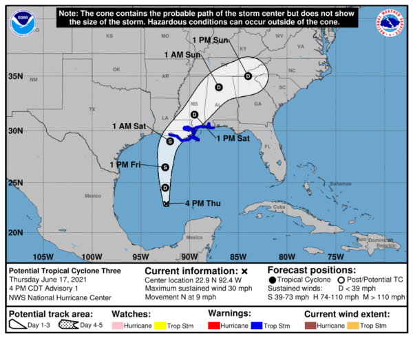
Potential Tropical Cyclone Number 3 is expected to become a tropical depression later tonight and a tropical storm by noon tomorrow, when it will most likely be named Claudette since there isn’t anything else threatening in the tropical Atlantic for now.
By 6 p.m. tomorrow evening, the center will be a little less than 200 miles southwest of New Orleans. It should make landfall on the Central Louisiana coast between Intracoastal City and New Morgan City before sunrise Saturday with top winds between 40-50 mph. By then, it will be turning to the northeast. It will quickly weaken to a depression as it crosses Southeast Louisiana and moves into southern Mississippi during the day Sunday.
It will pass across Central and North Alabama Saturday night in the general vicinity of I-59 and be over the mountains of North Carolina and Georgia by Sunday afternoon.
CENTRAL ALABAMA
A few showers on the extreme outer parts of the system will move into the area around the start of the afternoon hours on Friday while being widely spaced at that time. The better chances for the heavier tropical showers will move in on Saturday morning after daybreak over the southern portions of Central Alabama and eventually spreading northward throughout the day. Sunday will start off wet at times, but those tropical showers will begin to dissipate in coverage as the center of the system moves out of the state and further away. We may possibly see some dry weather during the late afternoon into the early evening hours.
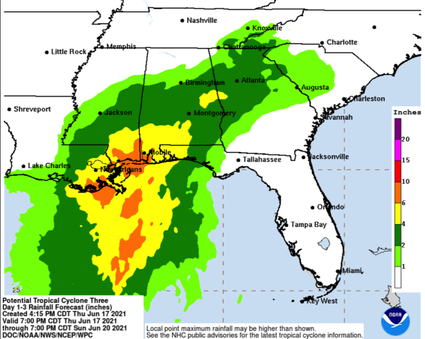
Winds will be breezy at times as the center makes its way through the area, with gusts up to 20-40 mph (possible). The higher wind gusts will likely take place closest to the center and just off to the east. Rainfall amounts across the area on Saturday through Sunday will range from as low as 1/2-inch in the northern and northwestern parts of the area to as high as 3-4 inches in the southern half of the area. Some localized amounts could reach 4-6 inches where those heavier and more intense bands move across. Some flash flooding issues may occur and Flash Flood Watches may be issued as early as tomorrow afternoon.
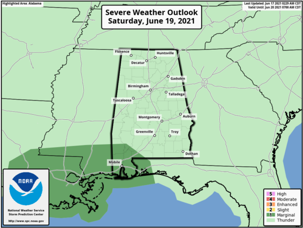
We’ll also have to watch for the potential of a few brief spin-up tornadoes mainly across the southern and eastern portions of the area as those locations will be on the east side (the more active side) of the center. For now, the SPC has only the extreme southwestern portions of the state in a Level 1/5 Marginal Risk for severe storms on Saturday, but that may be expanded northward and eastward sometime before landfall.
SHOULD I CANCEL MY BEACH TRIP: In a word, no. But it depends on your tolerance for hanging out in the hotel, condo, or beach house while it rains for a while. The weather will improve on Sunday.
BUT STAY OUT OF THE WATER! Double red flags will be flying along much of the beaches by tomorrow and we have already suffered too many fatalities along our beaches this year thanks to rip currents. The dangerous conditions will last through at least Sunday night.
ALABAMA GULF COAST
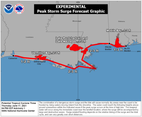
Showers will start along the beaches of Baldwin and Mobile Counties Friday morning, with increasing rain Friday night. Rain will begin to diminish on Sunday. Rainfall amounts could reach 6-8 inches with isolated higher amounts across Coastal Alabama, with flooding a significant threat. Winds will be gusty tomorrow, and will increase to around 15-25 mph by late tomorrow, continuing Friday night into Saturday morning. Winds could gust to tropical storm force (40-45 mph), especially if the track is a little more easterly. Storm surge could reach 1-3 feet along the Mississippi Coast. The rip current risk will become HIGH on Friday lasting through Sunday night. There will be a risk of tornadoes and waterspouts late Friday into Saturday.
PENSACOLA-FORT WALTON
You will see a few showers tomorrow with heavier rain beginning Friday night lasting into Sunday before diminishing. Rainfall amounts will be 4-8 inches. Winds will start gusting to 15-20 mph tomorrow with 15-25 mph winds with occasional gusts to 35 mph on Saturday. The rip current risk will be high starting Friday through Sunday night. Watch for waterspouts. Storm surge should not be a problem.
DESTIN-30A
The Emerald Coast will see a few showers tomorrow with heavier rain beginning Friday night lasting into Sunday before diminishing. Rainfall amounts will be 4-6 inches. Winds will start gusting to 15-20 mph tomorrow with 15-25 mph winds with occasional gusts to 30 mph on Saturday. The rip current risk will be high starting Friday through Sunday night. Watch for waterspouts. Storm surge should not be a problem.
PANAMA CITY
A few showers may move across the area during the late morning to the early afternoon hours on Friday, but the main bulk of the tropical showers and storms will start to move in by the late-night hours on Friday night and will persist at times through late Sunday morning. The surf will become rough on Friday with waves reaching heights of 3-6 feet at times with the very high potential of life-threatening rip currents. Wind gusts may reach as high as 30-35 mph at times from Saturday morning through the afternoon and early evening hours. Storm surge should not be an issue at this time, but a few waterspouts may be possible during the day on Saturday. Rainfall amounts look to be around 2-4 inches.
MISSISSIPPI GULF COAST
Showers will begin Friday morning with occasional gusty winds. Heavier rain will arrive after dark Friday evening. Winds will approach tropical storm force in gusts Friday night before midnight, with winds increasing to around 25-35 mph at times during the overnight hours. Tropical Storm Warnings are in effect in case the storm moves a little further east than the official track, in which case winds of 35-45 mph are possible. Storm surge could reach 2-3 feet along the Mississippi Coast. There could be a few tornadoes or waterspouts Friday afternoon through the overnight hours and into early Saturday. Rainfall will be very heavy with up to 8 inches forecast and isolated 12 inch amounts possible. Flooding will be likely. Conditions will slowly improve after midnight Saturday night.
NEW ORLEANS
Showers will begin tomorrow with heavy rain moving in tomorrow night. Winds will approach tropical storm force in gusts Friday night before midnight, with winds increasing to around 30-40 mph. There could be a few tornadoes or waterspouts Friday afternoon through the overnight hours over Southeast Louisiana. Rainfall will be very heavy with up to 8 inches forecast and isolated 12 inch amounts possible. Flooding will be likely. Conditions should improve after noon on Saturday.
Category: Alabama's Weather, ALL POSTS, Severe Weather, Tropical


