Severe Threat Continues Across the Mid-South and South, Including Alabama
We continue to watch strong to severe thunderstorms across a large area of the Mid-South and Southeast ahead of an approaching cold front.
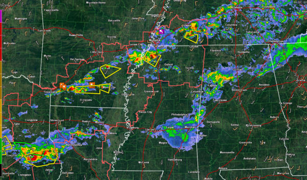
Storms continue from Middle Tennessee back into northwestern Mississippi, and southeastern Arkansas early this evening. A tornado was reported in Tipton County, TN northeast of Millington around 5:28 p.m. These storms are now in the Mercer area south of Jackson. Power issues have been reported in Jackson, TN.
No tornado warnings at this hour, but several severe thunderstorm warnings. A severe thunderstorm watch continues from southeastern Arkansas across northern Mississippi and southwestern Tennessee. Storms in the watch area continue to increase and are capable of producing severe weather including damaging winds, large, and a couple of tornadoes are possible. This activity will move into Northwest Alabama within the next two hours. It should become more linear in nature with time, as the low-level flow begins to increase. It is unclear whether the watch will be extended eastward later.
The severe threat continues over northeast Texas, northern and Central Louisiana, and southern Arkansas. Large hail and damaging winds will be the main threat, but there is also an isolated tornado threat with stronger storms. Some very large hail (greater than 2 inches in diameter is possible across this area as well.
Closer to home at 6 p.m.: showers and storms continue across Northwest and West Central Alabama back into eastern Mississippi. The storms are not severe at this time but do have lots of lightning, heavy rain, and some small hail. In Alabama, the main activity is over Walker County.
We will be tracking the line of storms as it comes together and pushes into Northwest Alabama over the next few hours, along with any storms that form ahead of it.
Stay tuned for later updates and warnings as we go through the evening. The severe threat should end for Alabama by midnight.
Category: Alabama's Weather, ALL POSTS


