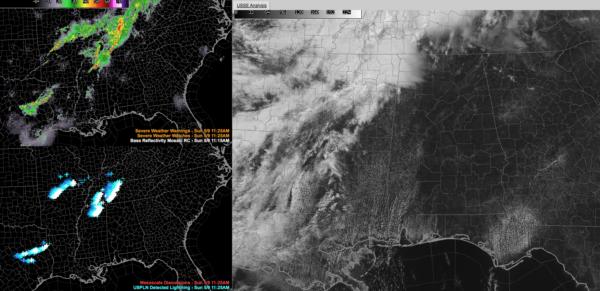
Late Morning Alabama Update: Storms Over Northern Mississippi, Mostly Suuny for Now Across Alabama
It’s a beautiful day across Alabama. The only clouds are some fields of cumulus over the western counties, a sign of increasing moisture, and some high cirrus blowing off from thunderstorms over northern Mississippi between Oxford, Corinth, and Tupelo. Those storms aren’t severe, but they are producing lots of lightning. These storms extend up through Middle Tennessee to near Nashville.
You can see the moisture gradient across the state clearly now with Anniston reporting a dewpoint of 53F, Birmingham 54F, and Tuscaloosa 64F.
It’s warm, with temperatures in the mid and upper 70s across the state. At 11 a.m. it was 79F at Birmingham and Tuscaloosa, and 78F at Anniston. Highs will top out in the middle 80s today.
It is quite breezy, with southwest winds averaging 9-24 mph and gusting to 32 mph in spots. The strongest gusts are over the Tennessee Valley, where Muscle Shoals reported that 32 mph gust last hour. Winds were gusting to 28 mph at Birmingham.
If the humidity were higher already, it would feel like a severe weather day. And as those moisture levels rise this afternoon, it will feel that way across the area.
Clouds will increase rapidly from the west over the next few hours, so enjoy the sun while you have it.
The latest severe weather outlook from the STorm Prediction Center is basically unchanged. It has a slight risk for Northwest Alabama with a marginal risk for to past I-59.
The severe weather threat will come between 4 and 11 p.m. this afternoon and evening as a cold front pushes towards Alabama, firing strong storms out of the high instability to our west. While there is no CAPE worth mentioning across Alabama right now, that will be changing. But instability values will be meager compared to the 3,500 joules/kg expected across Northeast Texas, southern Arkansas, northern Louisiana into western Mississippi. Hail will grow to large and very large sizes in the area from Longview to Texarkana, Shreveport, Monroe, Pine Bluff and Greenville, Mississippi later today and this evening.
These storms could produce a few tornadoes as well in this same area, as well as an elevated chance of damaging winds.
The storms will start working their way into Alabama after 3 p.m. They will carry the threat of damaging winds, hail, and a smaller chance of a couple of tornadoes as they work their way southeast during the late afternoon and evening.
Please pay attention to the latest updates through the afternoon and overnight here on the AlabamaWX Blog and make sure you have redundant ways of receiving warnings in case any are issued for your location.
Category: Alabama's Weather, ALL POSTS, Severe Weather


