The April 27th, 2011 Super Outbreak in My Own Words by Chris Darden
Before the storm…
The days leading up to April 27th were extremely busy and also a time filled with an unusual energy that accompanies potential high end severe weather days. I recall that we were at an Easter Egg Hunt the prior Saturday, April 23rd (our daughter was 9 then) when several parents came up to ask me about the weather for the following week. So word was already getting out. In fact, looking back at the forecast discussion and outlooks we were already highlighting significant impact weather for the coming Wednesday.
By Monday, briefings were in full swing and the media was requesting interviews at a rather rapid pace. One interview in particular struck me, especially in hindsight. A reporter asked the Warning Coordination Meteorologist David Nadler on April 26th – the day before – “is this going to be as bad as the April 3rd, 1974 tornado outbreak?” At first, I thought this was a crazy question but the more I thought about it and the more I looked at the data I too began to wonder. But little did we know what the next day would bring.
Based on the model guidance and trends we were expecting two waves of severe weather across north Alabama, with the afternoon wave expected to be the worst by far. We scheduled staffing accordingly, but with a relatively small staff it was certainly a challenge. I recall going to bed that Tuesday evening wondering exactly what the next day would bring. Truthfully it was an odd mix of dread, apprehension, and even some excitement, which I’m somewhat ashamed to admit in hindsight.
April 27th, 2011…
The initial wave (wave #1) of storms began to impact western Alabama shortly after 3 AM with areas of very intense/ damaging winds and embedded tornadoes. I awoke around 4:30 AM, looked at the radar on my phone and saw very quickly that the morning “event” was shaping up to be worse and more widespread than anticipated. Quickly, I got ready and headed into the office. The next few hours were a bit of a blur of constant activity with damage reports coming in from many counties. Parts of northeast Alabama and southern Tennessee were badly hit by the morning storms, with winds likely exceeding 100 mph in places by what could best be described as a small inland hurricane. Many areas would lose power for the remainder of the day which would be an issue in terms of alerting and awareness for the afternoon storms. Even at the time that was a huge concern for us, and some counties were already swamped and requesting mutual aid assistance.
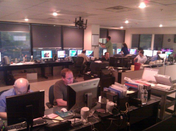
As soon as these morning storms moved off into Georgia and east Tennessee, another small but fast moving line began approaching northwest Alabama. These storms were, for lack of a better word, completely unexpected and threw a wrench into morning recovery efforts. This line produced periodic tornadoes and extensive damage particularly in parts of Limestone and Madison counties. In fact, many areas north of Highway 72 from Athens to Huntsville that were mostly spared by round #1 would lose power with these storms and never regain it again for days. Here’s a snapshot of what the NWS Huntsville operations area looked like around Noon on April 27th.
I recall at one point in the very early afternoon thinking (perhaps hoping) that this unexpected midday line of storms might put a damper on the potential for afternoon and evening supercells. A quick conference call with the Storm Prediction Center (SPC) put those hopes to rest. I probably can’t say the exact words here, but let’s just say the SPC forecaster was very descriptive in his terms for how the afternoon was going to go. Although after 10 years my memory is a bit hazy, I recall us having a very brief/impromptu internal meeting in the Huntsville operations area and deciding that we would only issue Tornado (TOR) Warnings through the remainder of the event. Any storm that didn’t warrant a TOR would not get any alert given the limited available infrastructure and trying to streamline communications going to the public.
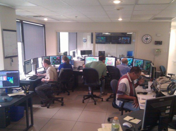
The first of the afternoon supercells ramped up very quickly near the Winston and Cullman county line shortly after 2 PM. This would become the first of many long track tornadoes of the afternoon and evening, and the first tornado emergency was issued around 3 PM. An interesting aspect to the afternoon storms, as we would certainly realize later, was how visible and well documented they would be. The Cullman tornado was caught live on the ABC 33/40 Cullman Skycam and we were able to track it’s progress for quite a while. In fact, we saw exactly when the Alabama Public Television (APT) tower and our Cullman NOAA Weather Radio Site was destroyed. A snapshot of the operations area during the afternoon is shown below.
It wasn’t very long before damage reports started rolling in fast and furious into the office. At this point, all you can do is try to get the warning information out and communicate with our partners and public and hope that (a) they can hear us and (b) they are taking necessary steps to save their lives. In the ensuing minutes and hours, more long track tornadoes would race across central and northern Alabama.
The next big storm to impact north Alabama was what would later be called the “Hackleburg tornado”. On radar, this storm looked extremely ominous with a notable debris ball (indicative of tornadic debris) as it moved through the town of Phil Campbell. Keep in mind, this event occurred just before the NEXRADR Dual Pol era, but we did have access to Dual Pol data from the local ARMOR radar which proved quite beneficial to assess the depth of the debris layers with many of the storms.
Perhaps the most concerning part of that time period is we were hearing nothing out of Franklin County. A good rule of thumb is if you aren’t hearing anything out of a city or county when an expected large tornado is moving through, you know it’s really REALLY bad. Anxiety was high in the office by this point as we had high end tornadoes on both ends of our area, and the storm moving out of Franklin county was making a beeline toward Huntsville if it held together. The reality strikes you that people are dying and you feel somewhat helpless.
About this time, we got a call from a local radio station that was simulcasting the local television broadcasts. Keep in mind, as I mentioned earlier, many people lost power during the mid day storms so people were relying on battery power radio, cell phones (if they could charge them), NOAA Weather Radio, or sirens (if the battery backup was still operable) for weather and warning information. The radio station asked us if we could give periodic live weather, radar, and warning updates. So several of us alternated doing the live simulcast via phone. Honestly, I don’t even remember what I was saying on there half the time. But it was amazing in the days that followed while out surveying how many people told me they heard me or another forecaster on the radio and it really helped their family while they were sheltering.
Things got really really intense as the storm moved into Limestone county. The tornado was caught on the live ALFA camera near French’s Mill. At roughly the same time, violent tornadoes were also occurring in Jackson and DeKalb counties (the latter being the redevelopment of the Cullman tornado). Needless to say, it was very busy in the office. The local (WAFF) media radar was destroyed live on the air and by that time the tornado was approaching western Madison county where many of our staff lived. I called home and told Kay that the tornado would likely track north of our house but we were monitoring another cell to the southwest (more on that later).
Reports of damage along I-65 start to roll in, and we finally start to get delayed reports of catastrophic damage from Lawrence county – still nothing from Franklin county. Not a criticism per se, but it was interesting to see all the focus on the tornado approaching Madison county while two big violent tornadoes are impacting northeast Alabama. We discuss taking shelter in the office for this tornado but determine it’s going to track north toward Harvest and Meridianville.
On the heels of the long track tornado, two additional storms spun up quickly with one showing a likely tornado near Madison. I called Kay and told her to shelter with Chloe (our daughter). While on the phone the line went dead. I tried to call back but couldn’t get through, and texts weren’t getting through either. A few minutes later, we started getting reports of damage near Gooch and Wall Triana, very near my neighborhood. At that point, all kinds of thoughts obviously go through your mind. Meanwhile we had other staff that were dealing with similar reports near/in their neighborhoods. As it turned out, my neighborhood had mostly minor damage (EF-0 to EF-1) and our house sustained primarily roof/minor structural damage and tree damage. I was finally able to find out later that Kay and Chloe were ok. What a relief!!
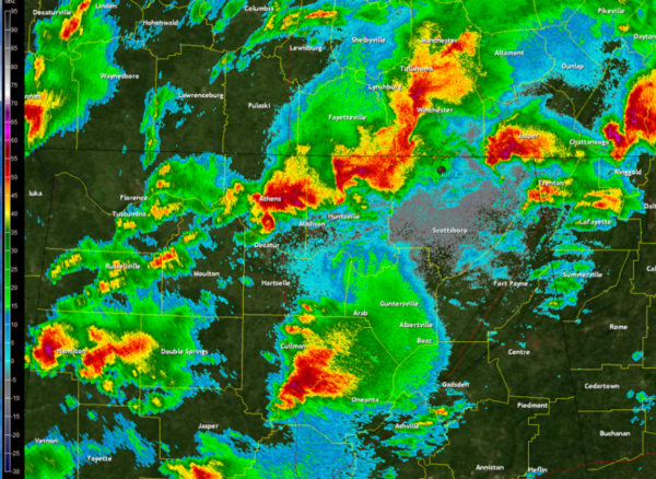
At roughly 516 PM, we notice that we’ve lost our radar feed from the Hytop (AL) NEXRAD. There were no storms that moved directly over the radar so we felt confident the radar wasn’t damaged. But it was unsure at first whether it was a comms or power issue. Not long after, we received a call from EMA that TVA had suffered a catastrophic network failure and most of north Alabama was without power and there was no restoral time. We sent out a statement to let everyone know. This is the last radar image from Hytop (HTX) Nexrad on April 27th, 2011.
Storms continued to track across the area in what seemed like an attacking swarm; I’m not sure how else to describe it. The last violent tornado to impact north Alabama was the Rainsville tornado during the late afternoon / early evening (around 6 PM). At the time we knew it was pretty bad, but we just didn’t know how bad given the closest radars available were Birmingham and Peachtree City. Little did we know at the time it would be the 4th and last EF-5 tornado of the outbreak. Damage reports kept rolling in from our ham radio operators (who were critical and outstanding keeping the flow of communications) and also via the Southern Linc 800 system which also stayed up.
As the evening wore on and storms finally exited the state, I don’t think any of us yet grasped just all that had unfolded on that long Wednesday. I also don’t think any of us realized the magnitude of the work ahead either. I remember coordinating with WCM David Nadler and late in the evening we sent an All Hands email asking for the staff to check in if they could and also letting folks know that they could show up to work the next few days and pretty much any amount of overtime was authorized. We also made an extra effort to check in with anyone who was in close proximity to the tornado paths. Fortunately, everyone was ok.
That night driving home was perhaps one of the eeriest experiences ever. There were very few lights on anywhere due to the power outage and hardly any cars out. As I got closer to Madison, activity picked up near one of the tornado tracks with police vehicles and barricades. I had to doubleback a few times to eventually make it closer to our neighborhood. Trees and power lines are down all along Gooch and Wall Triana so that’s tough navigating. I finally make it into the neighborhood and there’s people walking around in the dark with flashlights – lots of kids and some adults. Pull up into the driveway and quite a few folks come wandering over. They’re asking what all is going on as apparently the news has been slow to travel about the magnitude of the event.
Inside Kay and Chloe are visibly shaken and asking many of the same questions. They ask about the power, and I tell them what little I know that it’s a TVA issue and we hope to know more in the morning. At that point, I’m kind of wishing we had a generator. I know it’s gonna be a long few days so I try to wind down and get to bed as soon as possible. Fortunately the weather looks pretty good the rest of the week. As best I recall, that night’s sleep was pretty good and I awoke early.
Thursday, April 28th…
I called into the office to get an update on the power and any other logistics. The Senior Forecaster says what they’re hearing initially about the power grid isn’t good and it could be “some time” before the power is restored. He also said that a press conference was scheduled for later that morning. He also informed me that the fatality toll had gone way up overnight and was expected to rise as emergency crews continue to access the hardest hit areas. Some County EMs had been inquiring about surveys, but given the magnitude of the event most were still in search and rescue mode. I let him know I’ll be in ASAP. Based on that news, Kay and Chloe decide to spend a few days with family in Tennessee.
The first post-event day in the office was surreal. A dusk to dawn curfew had been implemented so that of course meant folks needed to to get out and see what was going on. The drive in was pretty hairy to be honest. More folks were out than I would have expected and again no power. Many people were treating street lights being out properly (as 4 way stops) while others were blowing right through them. It was kind of crazy. Once I got in, Dave and I talked briefly about a plan for the day and then I had a call with Headquarters about what resources we might need. At that point, I honestly didn’t even know – my head was still swimming.
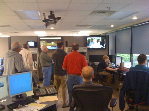
We decided to bring additional staff in to assist including the previous MIC Mike Coyne who was now at Southern Region but already on his way back to Alabama. I also had a live interview with WHNT and they were asking about total tornado tracks – “great question…next question”. We watched the morning press conference (photo below shows our ops area that morning) from downtown – Huntsville Utilities said it could be two weeks before power is restored. That took everyone aback for sure. Kudos to our electronics staff who had already arranged additional fuel delivery for our office generator. We then start to call around to our partners about getting access to fuel for our government vehicles, and we also start wargame car pooling for staff.
I don’t recall the exact timeline or details, but we sent several teams out on this day trying to hit some of the hardest hit areas. Rumors were already swirling around about the death toll and some numbers were being exaggerated on social media. What made things most challenging, and what people outside the area didn’t really understand, is that we had pretty much zero access to the outside world. In the office, we had dish connectivity, power (off generator) and ability to send/receive through our internal AWIPS system. But that was it. Literally. We had zero internet access in the office and cell coverage was all but down. You might catch a stray signal in the right spot but sending a text message could take hours. That lasted through the weekend. We did have comms through the Southern Linc 800 MHZ system which allowed us to talk with teams in the field and also reach some of our EM partners – but even that was spotty.
My initial plan for this day was to get on a Law Enforcement helicopter to do an overflight of the track in Limestone and Madison counties. I coordinated that with Limestone county. It took a LONG time to get out to East Limestone given all the traffic – my guess is some were folks unfortunately out sightseeing and others were trying to get supplies. The Incident Command Post was set up at East Limestone High and I met the chopper there. The school had been heavily damaged by the midday round of storms, and as I would soon see they were clipped by the long track tornado in the afternoon. Needless to say, the trip on the helicopter was an eye opener. In your mind, knowing how bad damage is might be one thing. Seeing how bad it is, well that’s something different altogether. We double back to the Tennessee River and fly the track from the Limestone line all the way into Madison. In hindsight, I wish we had flown further but he also had other local folks waiting to go up. As a side note, what was also interesting is that once we got up to “flying altitude” my phone basically blew up with texts and voice mails. The pilot said that it had been that way all morning, the only cell signal they could get was up in the air.
During the overflight, it became obvious very quickly that the damage just in those two counties was extreme and extensive. We flew over one area that looked particularly bad, and the pilot relayed over the headset “that’s Rosie Road, several fatalities occurred there”. We spent probably an hour up in the air and in hindsight it was unfortunate that I only had my iPhone 4 at the time to take photos. There were lots of rowing, multi-vortices, and other features you just could not pick out well with only an iPhone 4 camera. We did later acquire additional aerial imagery that was much better quality. Upon touching back down, I catch up with Lary Burgett (now retired NWS employee) and Dr. Kevin Knupp from UAH. They had arrived on scene to conduct a ground survey and were meeting up with Limestone EMA Director Rita White. Rita was handling the Incident Commander duties and had us set out on a ground survey with Jason Black, County Commissioner and son of previous EMA Director Spencer Black.
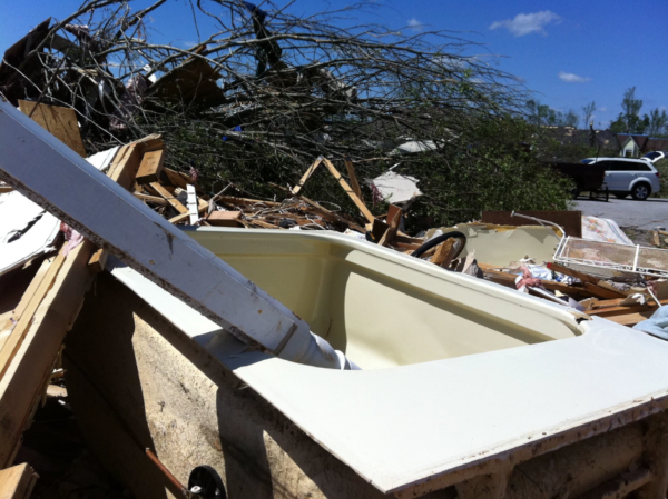
We hit several neighborhoods in the East Limestone area that were close to the school as a starting point. One gentleman tells a story of getting a call at work that his home was hit by the midday storms. When he got home, he and his wife started tarping their roof and assessing repairs when the weather radio goes off alerting them of another tornado approaching. They sheltered in their tub, and when the tornado hit it destroyed their home and they ended up landing 3 homes down unharmed (photo below). Imagine dealing with your home getting hit by one tornado at lunch time and then getting destroyed only a few hours later. Unbelievable, yet we heard many similar stories on this day.
A little further along Pepper Road we meet a family (at the Pepper Farmstead) that had significant damage to their farm. A couple of notable points here was they had just received a new combine that morning and the tornado moved the combine a significant distance. In addition, the owner showed us a tree that was downed on the property. On the tree was a carving with a date of April 3, 1974. Mr. Pepper told us their farm had also been hit and destroyed during the 1974 outbreak. We also ran into an elderly couple that lost everything. They sheltered in their basement and were ok. I recall the husband carved/made whirlybirds and there were pieces of his creations laying all over the place. While we were talking with him I guess the reality of it all sunk in and he just broke down. Then his wife broke down. We stayed with them for a while, and were able to get their insurance adjuster to come out who they had been waiting on.
Along McCulley Mill Road we ran into a lady sifting through the remains of her destroyed home. Truthfully that was probably the theme of Day One, talking to folks and hearing their stories of loss but also of survival. In this case, I recall her using a metal detector and searching. Lary and I asked her what she was looking for and it was her wedding bands. Somewhere about this time we see a lot of commotion and an ambulance rolling down the street. We get word that they’ve rescued someone out of the rubble. Praise God some good news!!
We proceed southwest to Highway 72. We stopped along the north side of the road where the WAFF radar was destroyed. Earlier during the overflight I saw part of the dish and antennae strown well away from the tower. There’s a church property here, and the pastor’s wife tells us that several families sheltered in the basement. Most of the church is destroyed but the basement is intact . A home across the street is destroyed and we learn later the occupant was thrown from the home but survived (photo below).
Jason then drives us over to Rosie Road. Turning off Highway 31 onto Rosie Road the damage on the ground looked even worse than it did from the air. Jason points to what was left of a house on the north side of the road (the Riddle family) and says two people lost their lives here. He mentioned that the son was there now, and we can talk with him if you want. It’s always hard when you talk to a surviving family member. You never know how they’re going to react, and I always try to be respectful and if they don’t want us there we move on. If they want to tell their story we take as much time as it takes and we listen while also documenting the damage. In this case, the son was not overly talkative and obviously deeply grieving but also respectful of the job we needed to get done. He showed us where his parents were found – about 100 yards away from the house – and his dad was clutching the grandchild (his child) when first responders found them. Amazingly the child was fine. He was also searching for his parents lock box that had their important documents in it. We stop and help him search to no avail.
We also talked to several other homeowners along this road, and heard many stories of survival amongst complete destruction. With Dr. Knupp’s assistance we deemed the damage initially EF-4 although we realized further analysis was needed. The day is getting short now, and it’s been a long day for everyone. We see several relief/disaster teams coming around offering meals and drinks. One church crew hands us a meal and I suddenly realize I haven’t eaten all day. About this time, we see a young boy sitting alone on the rubble of a destroyed home. We walk over to him and start talking. He tells us his family lives there and the rest of the family has gone out looking for supplies. Lary asks him if he’s had anything to eat and he says no. So Lary and I look at each other and we both hand him our bag of food. One of the police officers tells us that there’s a horse coming down the road that’s been injured by the storms. We see him in the distance with a large piece of wood sticking out his side. We find out later that they humanely put him down that evening. At that point, we called it a day and returned to the office.
One thing that became very clear very quickly was just how long these days were going to be. After returning to the office you still had to coordinate with the other survey teams and write up your part of the damage assessment. Depending on the track, that could take additional hours of work. Another added stress was the previously mentioned dusk to dawn curfew. So for staff there were additional concerns about getting pulled over and having to show ID. Something I also realized pretty quickly…I should have used sunscreen today. Hello sunburn.
Friday, April 29th…
Today started with a bit of good news. Mike Coyne from Southern Region Headquarters joined us to assist. We had another morning all hands meeting in the office and then came up with daily assignments. Mike and I headed up to Tennessee to try and knock out the various tornado tracks there with other teams heading out across north Alabama. We started in Lincoln County. As soon as we crossed the state line, the traffic on Highway 231 came to a crawl. Folks were lined up to get gas and other supplies as Lincoln County mostly had power. We also noticed restaurants were open, something I hadn’t seen anywhere the day before.
We went out with Lincoln EMA and TEMA this morning to assess damage and grabbed a quick lunch before heading out to Moore county. We met up with Jason Deal, Moore EMA Director, and then surveyed damage in that area. Some of the areas we surveyed in Moore county were quite wooded and rural, and we all ended up with a serious case of chiggers and ticks which resulted in some emergency triage on the side of the road. The long day ended near Huntland in Lincoln county where we found the end of the long track – Hackleburg tornado. Here we could tell the tornado briefly strengthened back to EF-3 and did significant damage to several farms. Of particular note was an area where very large hay bales were thrown hundreds of yards.
In the midst of the busyness on this day, I received a text message (actually had cell coverage) that folks were having issues with our storm surveys. Long story short, but I guess the social media experts were questioning the specific ratings for the surveys – even though at this point they were still very preliminary. The old adage “no good deed goes unpunished” comes to mind. Anyway, the person asked me what I wanted to do about it and I simply responded “nothing, we do nothing different – a coach doesn’t read a message board and change his gameplan”. Mike and I were fortunate enough to grab a nice meal on the way back at a church that was set up as a disaster assistance shelter. A home cooked meal sure came in handy this evening. Back at the office, the staff was notably tired and I could tell folks were feeling the stress and strain. We decided to rotate some folks out, and if staff wanted to skip surveys on Saturday they could. One huge positive, I believe it was on this day that former Huntsville Science Operations Officer Tom Bradshaw made the long trek from Fort Worth and dropped off a large load of supplies for the staff. With most businesses closed this was a huge help and morale booster. The day ended with a little more excitement as I got pulled over on the way home. Huntsville PD officer informed me that I was breaking curfew. After I showed him my work badge and explained what I was doing out so late he finally let me go after what seemed like a really long delay.
Saturday, April 30th…
Still no power and it’s an early dark rise again this day. We meet in operations and discuss assignments for the day. Rumors are swirling around that the Governor is coming to north Alabama for a press conference, and we get a call requesting we participate. But then plans change about 5 times in 30 minutes and we decide to scrap it. Emotions are running high this morning as we are all dealing with no power, little sleep, and being in a disaster zone for days now. We take some extra time to regroup internally, and I offer my house to a few folks to get a shower since I’m one of the few with hot water.
We also had one of our government vehicles break down the previous day, so I’m using my own car today. I head out with one of the forecasters to Jackson County which we know was hard hit. We had already surveyed Rainsville (DeKalb County) but two separate large tornadoes had also moved through Jackson county. We start out at the EMA office in Scottsboro, and the EMA director shows us a map with damage points on them – it’s pretty well covered and we realize quickly we weren’t finishing this up today.
The first stop was getting fuel, as gas was scarce and finding an open gas station was like a treasure hunt. EMA pointed us in the right direction and we got fueled up. We then headed out to the Flat Rock and Higdon areas near Highway 71. The damage in this part of the county was bad…real bad. We talked to a family in Flat Rock whose home was destroyed. They were basically asking us how bad it was elsewhere because they had very little contact with the outside world at this point. The lady mentioned that they did get our warnings and took shelter before the tornado hit. Thankfully the whole family was ok with minor injuries. She also told me that their oldest son survived a direct hit from the Tuscaloosa tornado but his roommate died. We all just stood there quietly for a while.
Further along the road, we run into a National Guard unit that was deployed and had some of the hardest hit areas blocked off. The officer tells us that several people perished up the street and we ask if he can escort us to the properties. He takes us to the remains of a rather large home (it seems) and there’s a makeshift tent with a young lady sitting under it. The officer tells us that she’s the only surviving family member and she found the bodies after returning home that evening. He also said she refused to leave and wasn’t talking. We quietly walk up to her, introduce ourselves and offer our condolences. She acknowledges us, but it’s obvious her mind is a million miles away. I ask her if she minds us taking a few photos for documentation and she says no. We quickly take care of our business here, and move on. Definitely a sobering moment.
A little while later, we wave goodbye to the National Guard team and go about our way further northeast toward the Georgia line. We come upon a large farmstead that has sustained significant damage. From the road, we notice a lady and two young girls picking through the rubble. We decide to stop and talk with them for a bit. As we walk up to the home we realize quickly that this area saw complete destruction. We introduced ourselves to the mother and my first comment was “thank God y’all weren’t home when the tornado hit”. She chuckled a bit and said “we were home”, and at that we both turned and looked for a storm shelter but didn’t see one.
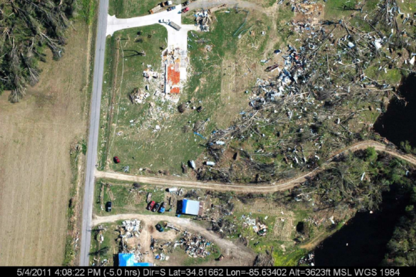
We asked her “where did y’all shelter?” and she pointed to the middle of what was left of the home. The forecaster and I looked at each other in amazement, and she then went on to explain how they lost everything and most of their belongings were found hundreds of yards away. She even showed us where the large appliances were found across the road. Most amazing was the large propane tank that was ripped out of the ground on the west side of the house and landed on the east (front) side of the house. The owner also told us that had many cattle that were tossed and thrown by the tornado, and she also showed us where they had carpet and plumbing pulled out of the house. The aerial photo of this home (below) shows the shear magnitude of destruction.
Through all of that, she, her husband, and two girls sheltered in the hallway and were uninjured from the tornado. She said her husband was injured trying to maneuver through the debris after the storm and was currently at the hospital. The forecaster and I just stood there in amazement realizing that 4 people were left untouched while everything else was lofted and thrown long distances including the carpeting, cemented fencing, and plumbing. All I could say to the family was “that’s a God thing” and we shared an emotional moment together as the day was drawing to a close.
We had a long drive back to this office this evening, and we documented a few additional damage points from Jackson back to Madison county. We also heard of significant damage up near Bridgeport (which we later surveyed as a separate EF-4) but daylight was waning. We arrived back late to the office this evening, and I recall correctly, we ran into some new forecasters from other offices including Nashville that had arrived to help support operations. Once again, I was pulled over on the way home this night.
Sunday, May 1st…
On Day Four, Sunday, Mike Coyne and I decided to head back to Lawrence and Franklin counties to try and wrap up that part of the “Hackleburg” track and connect the dots back to Madison county. We stopped briefly near Mt. Hope and saw extensive damage, on the order of EF-4. I found out later that an elderly couple survived in a drainage ditch in Mt. Hope in the middle of that carnage. So yes, you can survive a tornado in a ditch. When then proceeded to the Oak Grove community in Franklin county. We stop at a house along Highway 38 that is completely destroyed. We talk to the homeowner there that tells us how he had the home custom built including hurricane clips and extra fortifications. He was also a car collector and there are vehicles, or mostly parts of vehicles, strewn all along the landscape here. The owner said he was still missing one of his vehicles and asked if we could be on the lookout for it. He also tells us the story of a young couple that died in their vehicle not far from here trying to get to safety.
Further along Highway 38 and up to Smith Lane we see more devastation including debris littering the landscape. A pond near Smith Lane is filled with large debris. We find out much later that the missing vehicle is at the bottom of this lake. There’s a couple near here that tells their survival story. They sheltered in a safe room in their basement and barely made it out unscathed. The husband has his eyes all bandaged up and I assume he got hit by debris, but he tells me the pressure/force was so strong that he tore open his tear ducts. Their large RV/camper sits mangled down in a ravine a few hundred yards behind the house. Mike and I spot some other large items here too, like a mangled car in a tree, freezer, etc. A few days ago, this would have been an incredible site. By today, it was unfortunately normal viewing.
We realize at this point our digital camera is full and we need a new SD card, so we take a short side trip up to Russellville. They have power here which is one of the few spots around. We hit the store real quick, and decided to grab some lunch before heading to Phil Campbell. While in line we see the entire restaurant stand up in unison, face the west facing windows, and some patrons take their hats off. We look and we see a line of hearses driving south down the road. The funerals from April 27th have started. Suddenly neither of us are hungry anymore.
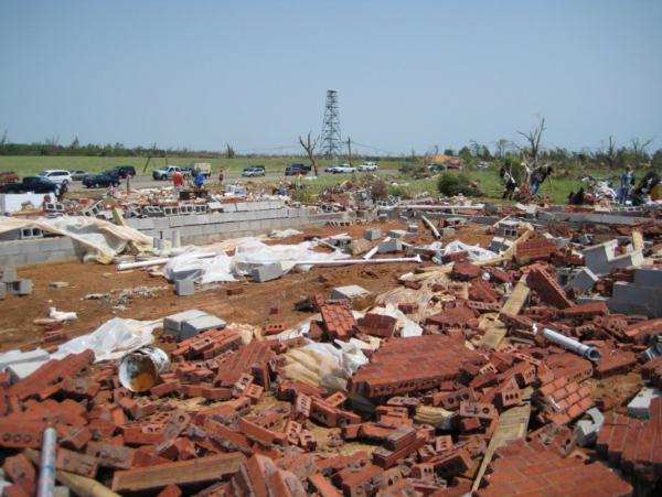
After a quick drive south toward Phil Campbell, we get into the damage zone. The tornado went right through the main residential area south of downtown here. And after four straight days of surveying, I can safely say this is the worst damage we’ve seen yet. Along Bonner and Brown Streets it is complete devastation. You look around, and you honestly are hard pressed to make out what used to be there. The landscape here looks almost unwordly.
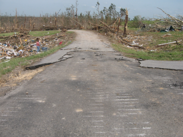
We walk up to the remnants of one home and there’s a lady and her son sifting through debris. She tells us she’s from Arkansas and her dad died here. We ask her if there’s anything we can help with, and she thanks us but responds not really she’s just looking for anything of value. We notice that she has collected some family photos. She then asks us if we noticed the street driving in. Mike and I look puzzled so she points toward the road. We notice that it looks in ill repair with parts of the road missing. She said it was just resurfaced not long ago and that was the first thing she noticed when driving in that the tornado had ripped up the roadway. Later on, we find huge chunks of the road inside a neighboring home. The shear force required to suck up the road is something hard for either of us to fathom. Mike and I collect a small piece to take back.
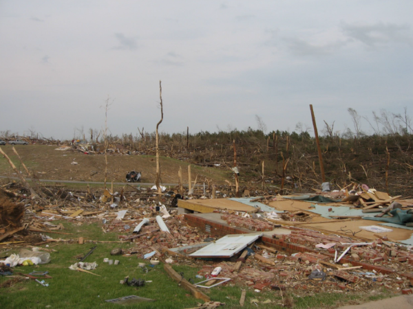
A lady across the street is also cleaning out, or searching through, the remnants of a home. She tells us her friend died there. The rest of the day is filled with very similar stories. We see multiple cars that are accordioned around trees like paper and homes turned to rubble. One constant we noticed in all the days of surveying was what I call missile fields. You would see these rows and rows of large pieces of debris impaled into the ground like missiles. You would also see the large divot and crater marks where things were bounced or dragged across the ground. The sheer enormity of which was incredible.
The drive back to the office this evening was more somber than normal. Having seen the funeral processions and experienced four straight days of devastation was really getting to me. We made a call to get a counselor to come into the office to meet with the staff, and they were scheduled for early in the upcoming week. I also decided not to go out the next day. I just couldn’t do it again. We also had decided on upgrading the Phil Campbell portion of the track to EF-5 based on today’s survey so we knew the media attention would be pretty high, the first EF-5 in north Alabama since 1974.
The Ensuing Days and Months…
The following week consisted of continual surveys and trying to get out to some of the other hard hit areas. We continued to get assistance from a variety of places including staff relief from Texas offices. With power still out and resources scarce, we received additional food/supply deliveries included from then MIC (Slidell) Ken Graham – now Director NHC. Ken drove up a large trailer of supplies that were badly needed by staff and family. Ken also stayed a few days to help with the post-event operations.
Power began to slowly come back on within 5 to 7 days. One of our staff members delivered her second child at Huntsville Hospital over the first post-storm weekend after coming back from maternity leave to assist the office on the 27th. Now that’s true dedication! All in all, during that period the Huntsville staff worked over 400 hours of overtime, and they would have gladly worked more to serve the community. We all took the losses personally, and each person was dealing with it in their own way. Having a professional counselor come in to assist really helped.
The workload remained high for many days and weeks, and we completed our last official storm survey on June 28th. In fact, the Rainsville tornado was upgraded from EF-4 to EF-5 in early June based on additional forensic evidence. After it was all said and done, 39 tornadoes and 109 fatalities were recorded in the Huntsville County Warning Area for the outbreak. The Alabama state totals for April 27th, 2011 would wind up at 62 tornadoes and 240 (direct) fatalities.
As we traveled the area for those many days and weeks, we saw neighbors helping neighbors and people pitching in to do what needed to be done. Even in my own neighborhood, I came home one evening to find my neighbors cleaning up my yard and removing downed trees and debris. One neighbor left a note saying “Thank you for everything you do to keep us safe.”. That is, in one example, what our state and our communities are all about. We also had the tremendous support of our emergency management, amateur radio, law enforcement, media, and academic partners who were vital in providing real-time support during the outbreak and assisted mightily with post-event and storm surveys.
I was frustrated at times that the publicity and resources were often directed at the larger cities and it seemed some of the smaller towns were being left behind in the recovery. Maybe that was more perception than reality as it has been encouraging to see the recovery and redevelopment across even the hardest hit areas in the decade since. But April 27th, 2011 will certainly be a day that none of us will ever forget, and we hope/pray that we never see a similar outbreak in our lifetimes.
For the 10 year anniversary, the Birmingham and Huntsville offices have done an incredible job putting this page together: https://04272011-noaa.hub.arcgis.com/
Category: Alabama's Weather, ALL POSTS, Met 101/Weather History, Severe Weather


