Convective Line with Strong Winds Approaching; New Watch May Be Coming for North Alabama
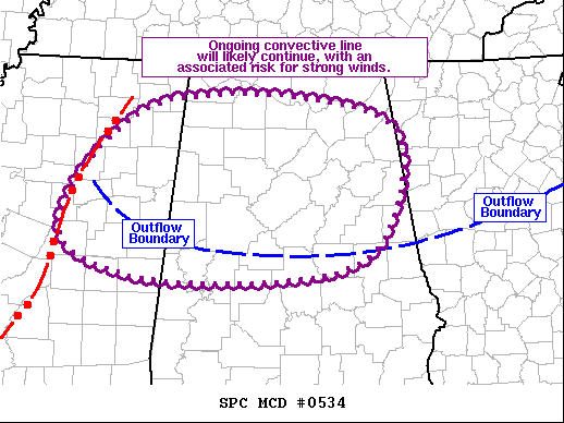
SUMMARY… Complex convective evolution is anticipated from west-central MS through northern/central AL over the next few hours. Strong winds appear most likely from east-central MS into west-central AL.
DISCUSSION… The strongest part of the ongoing convective line appears to be progressing through central MS currently. However, radar and surface observations reveal a remnant outflow boundary draped from northeast MS across central AL and through west-central GA. Western and central portions of this outflow boundary have stalled, with the western portion appearing to now move back northward as an effective warm front. Thunderstorms are ongoing north of the boundary across much of AL, which could impede any northward motion.
Given these mesoscale complexities, the overall convective evolution as the line begins to interact with this boundary is uncertain. Dewpoints are in the mid 60s across east-central MS and west-central AL, decreasing to closer to 60 over east-central AL and west-central GA. This is resulting is decreasing buoyancy from west to east, introducing additional uncertainty with how far north and east severe will occur with this convective line. Most probable area for strong wind gusts is from east-central MS into west-central AL where buoyancy remains strong. Elsewhere, convective trends will be monitored closely, with at least some potential for a watch over northern AL.
Category: Alabama's Weather, ALL POSTS, Severe Weather


