The Threat for Tornadoes, Large Hail, & Damaging Winds Continue Across Central Alabama
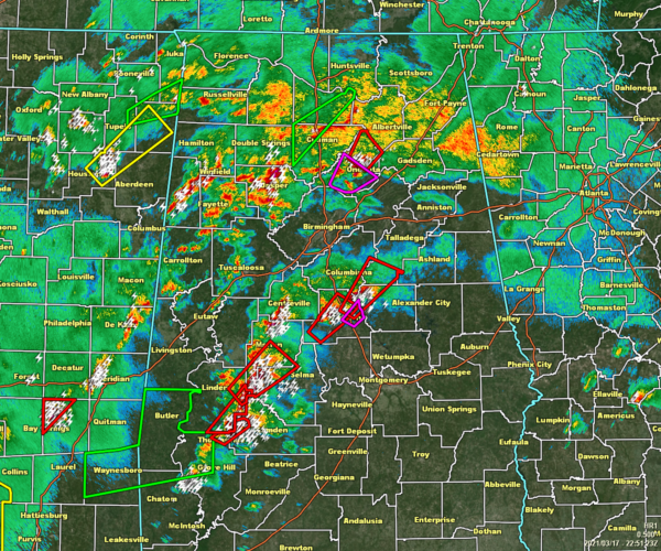
As of 5:55 pm, we continue to have multiple warnings in effect across Central Alabama as conditions continue to be favorable for the potential of all modes of severe weather, especially for tornadoes. We have heard of a few injuries and damage down in Chilton County, along with damage already shown on ABC 33/40 in the Gardendale area of North Jefferson County. The risk for more tornadic development and severe thunderstorms will continue for several more hours.
Some damage has just been reported in Oneonta as tress have been downed onto portions of US-231.
A small landslide occurred on HWY-227 in Guntersville, but should be cleared shortly.
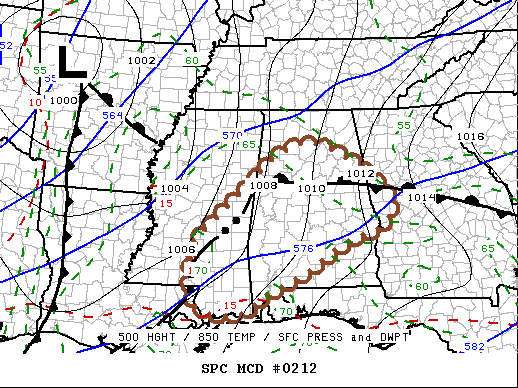
Here is the latest from the SPC’s Mesoscale Discussion #212
SUMMARY…
The risk for tornadoes, a couple of which could become strong and particularly damaging, is expected to continue to increase through mid to late evening as an organizing squall line overspreads the region. This may also be accompanied by more general strong to severe surface gusts. A new tornado watch will be needed by 7 PM CDT.
DISCUSSION…
Large-scale ascent, aided by lower/mid tropospheric warm advection beneath difluent high-level flow, continues to support discrete thunderstorm development within a relatively broad warm sector. Areas of the warm sector not substantially impacted by prior convection remain characterized by CAPE of 1000-2000 J/kg, and wind profiles across the region exhibit strong deep-layer shear and sizable, clockwise-curved low-level hodographs. This environment remains potentially conducive to long-lived supercells with strong low-level mesocyclones posing a risk for tornadoes.
While the onset of diurnal cooling could result in at least some decrease in instability by 00-01Z, favorable large-scale forcing for ascent seems likely to maintain discrete storm development across central Alabama, as a linear convective system continues to evolve upstream, across southeastern Louisiana through southern and eastern Mississippi. This is occurring ahead of a vigorous short wave trough turning east-northeast of the southern Great Plains. As this feature progresses into the lower/middle Mississippi Valley through mid/late evening, south-southwesterly 850 mb flow is forecast to strengthen in excess of 50 kt in a corridor along/ahead of the evolving squall line.
Further enlargement of low-level hodographs will maintain the risk for tornadoes with both the discrete supercells preceding the squall line and those forming within the squall line. This will include the potential for strong tornadoes. Otherwise, corridors of potentially damaging wind gusts will probably begin to increase as the evolving squall line continues to organize and accelerate northeastward.
Category: Alabama's Weather, ALL POSTS, Severe Weather


